Tocht Stappen Saint-Christophe-Vallon - Le Puech du Cayla  - Photo
 ZITO12
ZITO12

Gebruiker

© OpenStreetMap contributors
Lengte
Lengte
11,5 km
Max. hoogte
Max. hoogte
540 m
Positief hoogteverschil
313 m
Km-Effort
Km-Effort  
15,7 km
Min. hoogte
Min. hoogte
312 m
Negatief hoogteverschil
314 m
Boucle
Boucle
Ja
Datum van aanmaak :
2021-03-24 08:24:53.158
Laatste wijziging :
2021-03-24 13:25:32.504

(0 Bericht)

Stappen
Stappen
4h59
Moeilijkheid : Heel gemakkelijk

Scan deze QR-code om de tocht te openen in de SityTrail-applicatie

Gratisgps-wandelapplicatie

Logo SityTrail SityTrail

IGN / Geografische instituten

SityTrail uit de App Store downloaden SityTrail uit Google Play downloaden

Logo SityTrail SityTrail World

De wereld gaat voor u open

SityTrail uit de App Store downloaden SityTrail uit Google Play downloaden SityTrail op Huawei AppGallery downloaden

Over ons

Tocht Stappen van 11,5 km beschikbaar op Occitanië, Aveyron, Saint-Christophe-Vallon. Deze tocht wordt voorgesteld door ZITO12.

Beschrijving

Rando très facile avec de belles vues panoramiques. Beaucoup de passages en situation dominante. Petit bémol : un peu trop de goudron au départ mais sans circulation. Beaucoup de chants d'oiseaux au printemps.

Hoogteprofiel

Foto's

Plaatsbepaling

Land:
France
Regio :
Occitanië
Departement/Provincie :
Aveyron
Gemeente :
Saint-Christophe-Vallon
Locatie:
Unknown
Vertrek:(UTM)
453036 ; 4924196 (31T) N.

Wandeltochten in de omgeving

Tocht Stappen Clairvaux-d'Aveyron - Clairvaux les vignes  - Photo
Stappen
ZITO12

Stappen

Medium
Clairvaux-d'Aveyron, Occitanië, Aveyron, France
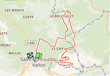
11,7 km | 17,7 km-effort
3h 34min
Ja
Tocht Te voet Marcillac-Vallon - De la Vigne à la Forêt - Photo
Te voet
PRO

Te voet

Gemakkelijk
Marcillac-Vallon, Occitanië, Aveyron, France
10,1 km | 14,1 km-effort
3h 11min
Ja
Tocht Te voet Clairvaux-d'Aveyron - Le Puech du Puot - Photo
Te voet
PRO

Te voet

Gemakkelijk
Clairvaux-d'Aveyron, Occitanië, Aveyron, France
11,3 km | 16 km-effort
3h 38min
Neen
Tocht Te voet Marcillac-Vallon - Le Puech du Cayla - Photo
Te voet
PRO

Te voet

Gemakkelijk
Marcillac-Vallon, Occitanië, Aveyron, France
5,5 km | 7,9 km-effort
1h 47min
Neen
Tocht Te voet Nauviale - chemin Gare de Saint-Christophe - Conques - Photo
Te voet
PRO

Te voet

Gemakkelijk
Nauviale, Occitanië, Aveyron, France
6,9 km | 8 km-effort
1h 48min
Neen
Tocht Te voet Valady - Des Vignes aux Moulins - Photo
Te voet
PRO

Te voet

Gemakkelijk
Valady, Occitanië, Aveyron, France
11,3 km | 15,2 km-effort
3h 26min
Ja
Tocht Stappen Valady - Valady nuces serres  - Photo
Stappen
ZITO12

Stappen

Gemakkelijk
Valady, Occitanië, Aveyron, France
12,6 km | 16,9 km-effort
4h 7min
Neen
Tocht Stappen Goutrens - Autour de Goutrens - Photo
Stappen
tracegps

Stappen

Medium
Goutrens, Occitanië, Aveyron, France
11,7 km | 15,2 km-effort
3h 15min
Ja
Tocht Stappen Clairvaux-d'Aveyron - Autour de Panat - Photo
Stappen
tracegps

Stappen

Medium
Clairvaux-d'Aveyron, Occitanië, Aveyron, France
10,9 km | 15,4 km-effort
3h 15min
Ja


Sluiten
Mijn abonnementen