Tocht Paardrijden Le Malzieu-Forain - Etoile Première boucle  Pré hiver 25 km - Photo

Etoile Première boucle Pré hiver 25 km

 Lozère Cheval
Lozère Cheval

Gebruiker

© OpenStreetMap contributors
Lengte
Lengte
25 km
Max. hoogte
Max. hoogte
1398 m
Positief hoogteverschil
826 m
Km-Effort
Km-Effort  
36 km
Min. hoogte
Min. hoogte
963 m
Negatief hoogteverschil
709 m
Boucle
Boucle
Neen
Datum van aanmaak :
2020-06-29 10:52:31.722
Laatste wijziging :
2020-06-30 07:50:12.834

(0 Bericht)

Paardrijden
Paardrijden
1h04
Moeilijkheid : Gemakkelijk

Scan deze QR-code om de tocht te openen in de SityTrail-applicatie

Gratisgps-wandelapplicatie

Logo SityTrail SityTrail

IGN / Geografische instituten

SityTrail uit de App Store downloaden SityTrail uit Google Play downloaden

Logo SityTrail SityTrail World

De wereld gaat voor u open

SityTrail uit de App Store downloaden SityTrail uit Google Play downloaden SityTrail op Huawei AppGallery downloaden

Over ons

Tocht Paardrijden van 25 km beschikbaar op Occitanië, Lozère, Le Malzieu-Forain. Deze tocht wordt voorgesteld door Lozère Cheval.

Beschrijving

tracés valerie verrier

Hoogteprofiel

Plaatsbepaling

Land:
France
Regio :
Occitanië
Departement/Provincie :
Lozère
Gemeente :
Le Malzieu-Forain
Locatie:
Unknown
Vertrek:(UTM)
527589 ; 4969916 (31T) N.

Wandeltochten in de omgeving

Tocht Stappen Le Malzieu-Ville - Malzieu/Apcher - Photo
Stappen
tyntyn

Stappen

Gemakkelijk
Le Malzieu-Ville, Occitanië, Lozère, France
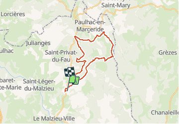
13,6 km | 17,7 km-effort
4h 4min
Ja
Tocht Stappen Le Malzieu-Ville - LE MALZIEU - APCHER  - Photo
Stappen
walrou63

Stappen

Medium
(1)
Le Malzieu-Ville, Occitanië, Lozère, France
17 km | 23 km-effort
4h 21min
Ja
Tocht Paard Le Malzieu-Forain - MAJ 21 DRAILLE EN MARGERIDE 2eme partie vers Saugues - Photo
Paard
Lozère Cheval

Paard

Heel gemakkelijk
Le Malzieu-Forain, Occitanië, Lozère, France
50 km | 64 km-effort
Onbekend
Ja
Tocht Stappen Le Malzieu-Ville - tour du lac de la graviére de la Chazette - Photo
Stappen
Denicheur

Stappen

Gemakkelijk
Le Malzieu-Ville, Occitanië, Lozère, France
4,9 km | 5,2 km-effort
1h 9min
Ja
Tocht Stappen Le Malzieu-Forain - Lozere - Le Villard-Le-Malzieu-Ville Les trucs de Malzieu-Forain 24km 633m - Photo
Stappen
RandoVal

Stappen

Moeilijk
Le Malzieu-Forain, Occitanië, Lozère, France
24 km | 34 km-effort
7h 2min
Ja
Tocht Stappen Le Malzieu-Forain - Lozere - Le Villard-Le-Malzieu-Ville Les trucs de Malzieu-Forain 18km 477m - Photo
Stappen
RandoVal

Stappen

Medium
Le Malzieu-Forain, Occitanië, Lozère, France
18,2 km | 26 km-effort
5h 22min
Ja
Tocht Stappen Le Malzieu-Forain - Lozere - Le Villard-Le-Malzieu-Ville Les trucs de Malzieu-Forain 14km 410m - Photo
Stappen
RandoVal

Stappen

Gemakkelijk
Le Malzieu-Forain, Occitanië, Lozère, France
13,6 km | 19,9 km-effort
4h 8min
Ja
Tocht Stappen Le Malzieu-Forain - Saint Pierre le Vieux - Photo
Stappen
tracegps

Stappen

Gemakkelijk
Le Malzieu-Forain, Occitanië, Lozère, France
6,3 km | 8,4 km-effort
1h 40min
Ja
Tocht Stappen Le Malzieu-Ville - Molières - Photo
Stappen
tracegps

Stappen

Gemakkelijk
Le Malzieu-Ville, Occitanië, Lozère, France
4,3 km | 6 km-effort
1h 0min
Ja


Sluiten
Mijn abonnementen