Tocht Andere activiteiten Evolène - Dent Blanche  Salay -refuge - Photo

Dent Blanche Salay -refuge

 tello
tello

Gebruiker

© OpenStreetMap contributors
Lengte
Lengte
5,9 km
Max. hoogte
Max. hoogte
3530 m
Positief hoogteverschil
1644 m
Km-Effort
Km-Effort  
22 km
Min. hoogte
Min. hoogte
1876 m
Negatief hoogteverschil
1 m
Boucle
Boucle
Neen
Datum van aanmaak :
2014-12-11 00:00:00.0
Laatste wijziging :
2014-12-11 00:00:00.0

(0 Bericht)

Andere activiteiten
Andere activiteiten
--
Moeilijkheid : Onbekend

Scan deze QR-code om de tocht te openen in de SityTrail-applicatie

Gratisgps-wandelapplicatie

Logo SityTrail SityTrail

IGN / Geografische instituten

SityTrail uit de App Store downloaden SityTrail uit Google Play downloaden

Logo SityTrail SityTrail World

De wereld gaat voor u open

SityTrail uit de App Store downloaden SityTrail uit Google Play downloaden SityTrail op Huawei AppGallery downloaden

Over ons

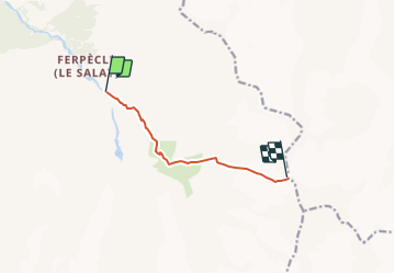
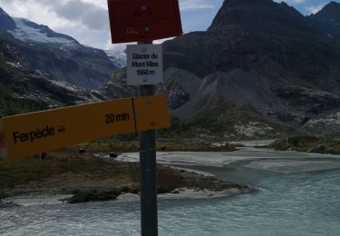
Tocht Andere activiteiten van 5,9 km beschikbaar op Valais/Wallis, Hérens, Evolène. Deze tocht wordt voorgesteld door tello.
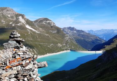
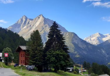
Beschrijving

1er jour

Montée au refuge depuis Salay

Hoogteprofiel

Plaatsbepaling

Land:
Switzerland
Regio :
Valais/Wallis
Departement/Provincie :
Hérens
Gemeente :
Evolène
Locatie:
Unknown
Vertrek:(Dec)
Vertrek:(UTM)
387869 ; 5101778 (32T) N.

Wandeltochten in de omgeving

Tocht Stappen Anniviers - Cabane de Moiry - Zinal / Jour 7 - Photo
Stappen
Greg813

Stappen

Moeilijk
Anniviers, Valais/Wallis, Sierre, Switzerland
17,5 km | 30 km-effort
4h 59min
Neen
Tocht Stappen Evolène - CHX ZRMT Étape 7 de La Sage à Zinal  - Photo
Stappen
jeff2

Stappen

Medium
Evolène, Valais/Wallis, Hérens, Switzerland
25 km | 50 km-effort
7h 57min
Neen
Tocht Stappen Evolène - glacier mont miné  - Photo
Stappen
vtaquin

Stappen

Medium
Evolène, Valais/Wallis, Hérens, Switzerland
3,3 km | 6,5 km-effort
1h 31min
Ja
Tocht Stappen Evolène - La Sage – Cabane de Moiry / Jour 6 - Photo
Stappen
Greg813

Stappen

Moeilijk
Evolène, Valais/Wallis, Hérens, Switzerland
11,3 km | 30 km-effort
4h 26min
Neen
Tocht Noords wandelen Evolène - glacier Miné  - Photo
Noords wandelen
suzanne.bron

Noords wandelen

Heel gemakkelijk
Evolène, Valais/Wallis, Hérens, Switzerland
5,9 km | 8 km-effort
1h 56min
Ja
Tocht Stappen Evolène - vs_hike674d - Photo
Stappen
GUIDE+

Stappen

Heel gemakkelijk
Evolène, Valais/Wallis, Hérens, Switzerland
18 km | 41 km-effort
7h 2min
Neen
Tocht Stappen Evolène - bg_tsate - Photo
Stappen
GUIDE+

Stappen

Heel gemakkelijk
Evolène, Valais/Wallis, Hérens, Switzerland
3,6 km | 12,7 km-effort
2h 1min
Neen
Tocht Noords wandelen Evolène - arola  - Photo
Noords wandelen
suzanne.bron

Noords wandelen

Heel gemakkelijk
Evolène, Valais/Wallis, Hérens, Switzerland
10,2 km | 14,8 km-effort
2h 43min
Neen
Tocht Noords wandelen Evolène - descente de la cabane du tsa  - Photo
Noords wandelen
suzanne.bron

Noords wandelen

Heel gemakkelijk
Evolène, Valais/Wallis, Hérens, Switzerland
3,2 km | 5,8 km-effort
1h 14min
Neen


Sluiten
Mijn abonnementen