Tocht Stappen Curières - La croix du Pal Aveyron  - Photo

La croix du Pal Aveyron

 tercla
tercla

Gebruiker

© OpenStreetMap contributors
Lengte
Lengte
15,6 km
Max. hoogte
Max. hoogte
1322 m
Positief hoogteverschil
467 m
Km-Effort
Km-Effort  
22 km
Min. hoogte
Min. hoogte
925 m
Negatief hoogteverschil
482 m
Boucle
Boucle
Ja
Datum van aanmaak :
2020-08-07 07:29:12.225
Laatste wijziging :
2020-08-13 16:23:03.03

(0 Bericht)

Stappen
Stappen
4h17
Moeilijkheid : Gemakkelijk

Scan deze QR-code om de tocht te openen in de SityTrail-applicatie

Gratisgps-wandelapplicatie

Logo SityTrail SityTrail

IGN / Geografische instituten

SityTrail uit de App Store downloaden SityTrail uit Google Play downloaden

Logo SityTrail SityTrail World

De wereld gaat voor u open

SityTrail uit de App Store downloaden SityTrail uit Google Play downloaden SityTrail op Huawei AppGallery downloaden

Over ons

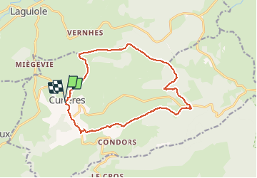
Tocht Stappen van 15,6 km beschikbaar op Occitanië, Aveyron, Curières. Deze tocht wordt voorgesteld door tercla.

Beschrijving

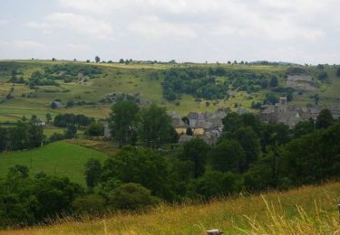
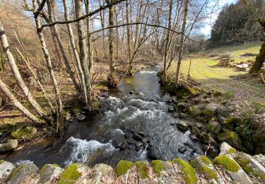
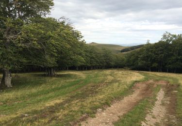
Belle randonnée dans les forêts de hêtres

Hoogteprofiel

Plaatsbepaling

Land:
France
Regio :
Occitanië
Departement/Provincie :
Aveyron
Gemeente :
Curières
Locatie:
Unknown
Vertrek:(UTM)
489273 ; 4944483 (31T) N.

Wandeltochten in de omgeving

Tocht Fiets Laguiole - Les courbes infinies de l'Aubrac - Laguiole - Photo
Fiets
tracegps

Fiets

Moeilijk
(1)
Laguiole, Occitanië, Aveyron, France
75 km | 90 km-effort
5h 0min
Ja
Tocht Stappen Laguiole - Laguiole - Station de ski - Photo
Stappen
neitag61

Stappen

Medium
(1)
Laguiole, Occitanië, Aveyron, France
7,1 km | 9,5 km-effort
1h 50min
Ja
Tocht Stappen Laguiole - Laguiole Roc Del Cabres  - Photo
Stappen
GUIDE
antignacs

Stappen

Gemakkelijk
Laguiole, Occitanië, Aveyron, France
12,3 km | 16,3 km-effort
3h 3min
Ja
Tocht Stappen Laguiole - Bouyssou sous la neige  - Photo
Stappen
GUIDE
antignacs

Stappen

Heel gemakkelijk
Laguiole, Occitanië, Aveyron, France
6,3 km | 7,5 km-effort
2h 2min
Ja
Tocht Stappen Laguiole - Laguiole Pigasse  - Photo
Stappen
Galoche

Stappen

Gemakkelijk
Laguiole, Occitanië, Aveyron, France
6,2 km | 8,4 km-effort
1h 47min
Ja
Tocht Stappen Laguiole - le roc des cabres - Photo
Stappen
bidetarou

Stappen

Gemakkelijk
Laguiole, Occitanië, Aveyron, France
13,7 km | 18,1 km-effort
4h 16min
Ja
Tocht Stappen Curières - la croix du Pal - Photo
Stappen
bidetarou

Stappen

Medium
Curières, Occitanië, Aveyron, France
15,2 km | 22 km-effort
4h 29min
Ja
Tocht Te voet Laguiole - Laguiole PR-5 - Photo
Te voet
PRO

Te voet

Gemakkelijk
Laguiole, Occitanië, Aveyron, France
6,3 km | 8,8 km-effort
1h 59min
Neen
Tocht Stappen Laguiole - Arioubadous  - Photo
Stappen
GUIDE
antignacs

Stappen

Gemakkelijk
Laguiole, Occitanië, Aveyron, France
14,1 km | 18,1 km-effort
3h 17min
Ja


Sluiten
Mijn abonnementen