Tocht Wegfiets Bethmale - seix  - Photo
 GuySimonin
GuySimonin

Gebruiker

© OpenStreetMap contributors
Lengte
Lengte
14,2 km
Max. hoogte
Max. hoogte
1393 m
Positief hoogteverschil
28 m
Km-Effort
Km-Effort  
17,6 km
Min. hoogte
Min. hoogte
502 m
Negatief hoogteverschil
915 m
Boucle
Boucle
Neen
Datum van aanmaak :
2020-08-31 15:27:03.844
Laatste wijziging :
2020-08-31 15:59:47.699

(0 Bericht)

Wegfiets
Wegfiets
28m
Moeilijkheid : Heel gemakkelijk

Scan deze QR-code om de tocht te openen in de SityTrail-applicatie

Gratisgps-wandelapplicatie

Logo SityTrail SityTrail

IGN / Geografische instituten

SityTrail uit de App Store downloaden SityTrail uit Google Play downloaden

Logo SityTrail SityTrail World

De wereld gaat voor u open

SityTrail uit de App Store downloaden SityTrail uit Google Play downloaden SityTrail op Huawei AppGallery downloaden

Over ons

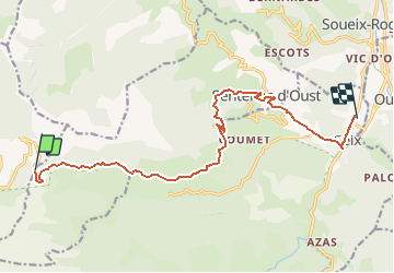
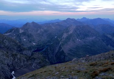
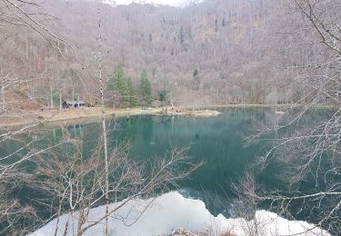
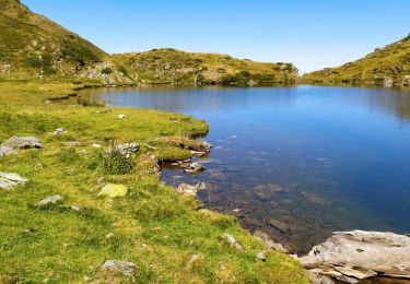
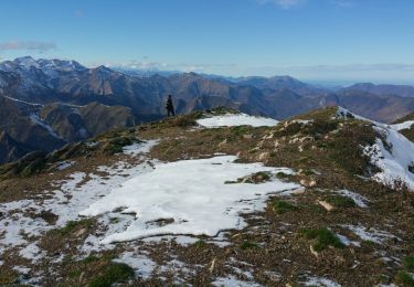
Tocht Wegfiets van 14,2 km beschikbaar op Occitanië, Ariège, Bethmale. Deze tocht wordt voorgesteld door GuySimonin.

Hoogteprofiel

Foto's

Plaatsbepaling

Land:
France
Regio :
Occitanië
Departement/Provincie :
Ariège
Gemeente :
Bethmale
Locatie:
Unknown
Vertrek:(UTM)
345184 ; 4746880 (31T) N.

Wandeltochten in de omgeving

Tocht Stappen Bethmale - Bethmale - Photo
Stappen
Gepeto_22

Stappen

Medium
(2)
Bethmale, Occitanië, Ariège, France
5,4 km | 8,8 km-effort
2h 20min
Ja
Tocht Stappen Bethmale -  Circuit des cinq étangs (2237m) - Photo
Stappen
tigrou31

Stappen

Moeilijk
(3)
Bethmale, Occitanië, Ariège, France
18,1 km | 33 km-effort
Onbekend
Ja
Tocht Stappen Bethmale - Cap de Bouirex - Photo
Stappen
counoise

Stappen

Moeilijk
Bethmale, Occitanië, Ariège, France
8,8 km | 16,1 km-effort
3h 18min
Ja
Tocht Stappen Seix - 2022 TRANSPYRÉNÉENNE : 6ème etape : Refuge d’Esbints - cabane Aula - Photo
Stappen
LEGUE

Stappen

Zeer moeilijk
Seix, Occitanië, Ariège, France
23 km | 38 km-effort
6h 18min
Neen
Tocht Te voet Bethmale - Grand circuit dans la Réserve Naturelle du Mont Valier - Photo
Te voet
PRO

Te voet

Gemakkelijk
Bethmale, Occitanië, Ariège, France
9,5 km | 19,6 km-effort
4h 26min
Neen
Tocht Stappen Bethmale - refuge Salvador - Photo
Stappen
chrisgps

Stappen

Zeer moeilijk
Bethmale, Occitanië, Ariège, France
16 km | 25 km-effort
5h 46min
Ja
Tocht Stappen Sentenac-d'Oust - 2020-08-25 col de la cor - col d'Auédole - étang d'Ayes - col d'Auédole - étang d'Eychelle - col de la core. - Photo
Stappen
jacq58

Stappen

Moeilijk
(1)
Sentenac-d'Oust, Occitanië, Ariège, France
11,4 km | 21 km-effort
4h 16min
Ja
Tocht Stappen Bethmale - cap de l'auternac  en boucle - Photo
Stappen
chrisgps

Stappen

Moeilijk
Bethmale, Occitanië, Ariège, France
15 km | 30 km-effort
7h 51min
Ja
Tocht Stappen Seix - Cabane d'Aula - Photo
Stappen
chrisgps

Stappen

Zeer moeilijk
Seix, Occitanië, Ariège, France
18,1 km | 31 km-effort
7h 2min
Ja


Sluiten
Mijn abonnementen