Tocht Stappen Viroinval - Quinwa 20200907 - Photo

Quinwa 20200907

 hannodi
hannodi

Gebruiker

© OpenStreetMap contributors
Lengte
Lengte
8,5 km
Max. hoogte
Max. hoogte
229 m
Positief hoogteverschil
156 m
Km-Effort
Km-Effort  
10,6 km
Min. hoogte
Min. hoogte
145 m
Negatief hoogteverschil
157 m
Boucle
Boucle
Ja
Datum van aanmaak :
07/09/2020 13:03
Laatste wijziging :
07/09/2020 15:04

(0 Bericht)

Stappen
Stappen
2h01
Moeilijkheid : Gemakkelijk

Scan deze QR-code om de tocht te openen in de SityTrail-applicatie

Gratisgps-wandelapplicatie

Logo SityTrail SityTrail

IGN / Geografische instituten

SityTrail uit de App Store downloaden SityTrail uit Google Play downloaden

Logo SityTrail SityTrail Plus

De wereld gaat voor u open

SityTrail uit de App Store downloaden SityTrail uit Google Play downloaden SityTrail op Huawei AppGallery downloaden

Over ons

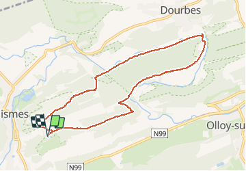
Tocht Stappen van 8,5 km beschikbaar op Wallonië, Namen, Viroinval. Deze tocht wordt voorgesteld door hannodi.

Hoogteprofiel

Foto's

Plaatsbepaling

Land:
Belgium
Regio :
Wallonië
Departement/Provincie :
Namen
Gemeente :
Viroinval
Locatie:
Nismes
Vertrek:(Dec)
Vertrek:(UTM)
611492 ; 5547672 (31U) N.


Sluiten
Mijn abonnementen