Tocht Stappen Nancy - Nancy Étang de Brin par Custines et Faulx et retour Nancy - Photo

Nancy Étang de Brin par Custines et Faulx et retour Nancy

 Toyot 8
Toyot 8

Gebruiker

© OpenStreetMap contributors
Lengte
Lengte
50 km
Max. hoogte
Max. hoogte
413 m
Positief hoogteverschil
638 m
Km-Effort
Km-Effort  
59 km
Min. hoogte
Min. hoogte
177 m
Negatief hoogteverschil
638 m
Boucle
Boucle
Ja
Datum van aanmaak :
2020-12-16 05:43:55.344
Laatste wijziging :
2020-12-16 15:38:25.78

(0 Bericht)

Stappen
Stappen
8h16
Moeilijkheid : Heel gemakkelijk

Scan deze QR-code om de tocht te openen in de SityTrail-applicatie

Gratisgps-wandelapplicatie

Logo SityTrail SityTrail

IGN / Geografische instituten

SityTrail uit de App Store downloaden SityTrail uit Google Play downloaden

Logo SityTrail SityTrail World

De wereld gaat voor u open

SityTrail uit de App Store downloaden SityTrail uit Google Play downloaden SityTrail op Huawei AppGallery downloaden

Over ons

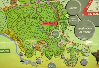
Tocht Stappen van 50 km beschikbaar op Grand Est, Meurthe-et-Moselle, Nancy. Deze tocht wordt voorgesteld door Toyot 8.

Beschrijving

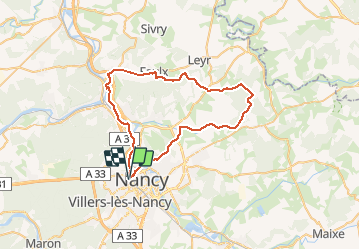
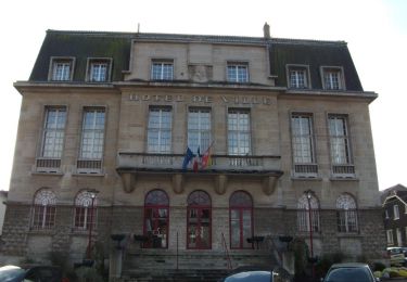
Nancy Custines Faulx Écuelle Étang de Brin Agincourt Dommartemont Malzéville Nancy

Hoogteprofiel

Foto's

Plaatsbepaling

Land:
France
Regio :
Grand Est
Departement/Provincie :
Meurthe-et-Moselle
Gemeente :
Nancy
Locatie:
Unknown
Vertrek:(UTM)
291629 ; 5397239 (32U) N.

Wandeltochten in de omgeving

Tocht Te voet Champigneulles - Circuit du Val Saint-Barthélémy - Photo
Te voet
PRO

Te voet

Gemakkelijk
Champigneulles, Grand Est, Meurthe-et-Moselle, France
7 km | 8,6 km-effort
1h 57min
Ja
Tocht Te voet Champigneulles - Circuit du Noirval - Photo
Te voet
PRO

Te voet

Gemakkelijk
Champigneulles, Grand Est, Meurthe-et-Moselle, France
11,1 km | 13,5 km-effort
3h 4min
Ja
Tocht Stappen Vandœuvre-lès-Nancy - Randonnée USEP 2023 - Photo
Stappen
nicolas54230

Stappen

Moeilijk
(1)
Vandœuvre-lès-Nancy, Grand Est, Meurthe-et-Moselle, France
11,7 km | 15,2 km-effort
3h 27min
Neen
Tocht Stappen Nancy - Ma rando du jour - Photo
Stappen
Toyot 8

Stappen

Moeilijk
Nancy, Grand Est, Meurthe-et-Moselle, France
35 km | 41 km-effort
5h 55min
Ja
Tocht Stappen Nancy - Nancy Gondreville Nancy - Photo
Stappen
Toyot 8

Stappen

Moeilijk
Nancy, Grand Est, Meurthe-et-Moselle, France
64 km | 74 km-effort
10h 57min
Ja
Tocht Stappen Nancy - Nancy Saizeray Jaillon Pierre la Treiche Marion Nancy  - Photo
Stappen
Toyot 8

Stappen

Moeilijk
Nancy, Grand Est, Meurthe-et-Moselle, France
73 km | 85 km-effort
12h 13min
Ja
Tocht Stappen Villers-lès-Nancy - RANDO DUO AVEC ALEXIS - Photo
Stappen
Toyot 8

Stappen

Moeilijk
(1)
Villers-lès-Nancy, Grand Est, Meurthe-et-Moselle, France
38 km | 45 km-effort
10h 19min
Neen
Tocht Te voet Champigneulles - Circuit G : Circuit principal - Photo
Te voet
PRO

Te voet

Gemakkelijk
Champigneulles, Grand Est, Meurthe-et-Moselle, France
8,4 km | 11,1 km-effort
2h 31min
Neen
Tocht Te voet Villers-lès-Nancy - Promenade d'Hardeval - Photo
Te voet
PRO

Te voet

Gemakkelijk
Villers-lès-Nancy, Grand Est, Meurthe-et-Moselle, France
3,2 km | 4,3 km-effort
58min
Ja


Sluiten
Mijn abonnementen