Tocht Fiets Vauvert - DE_TOUR_EN_TOUR_en_CAMARGUE_GARDOISE - Photo

DE_TOUR_EN_TOUR_en_CAMARGUE_GARDOISE

 gmerminod
gmerminod

Gebruiker

© OpenStreetMap contributors
Lengte
Lengte
44 km
Max. hoogte
Max. hoogte
39 m
Positief hoogteverschil
204 m
Km-Effort
Km-Effort  
47 km
Min. hoogte
Min. hoogte
-5 m
Negatief hoogteverschil
205 m
Boucle
Boucle
Ja
Datum van aanmaak :
2014-12-10 00:00:00.0
Laatste wijziging :
2014-12-10 00:00:00.0

(1 Bericht)

Fiets
Fiets
2h46
Moeilijkheid : Medium

Scan deze QR-code om de tocht te openen in de SityTrail-applicatie

Gratisgps-wandelapplicatie

Logo SityTrail SityTrail

IGN / Geografische instituten

SityTrail uit de App Store downloaden SityTrail uit Google Play downloaden

Logo SityTrail SityTrail World

De wereld gaat voor u open

SityTrail uit de App Store downloaden SityTrail uit Google Play downloaden SityTrail op Huawei AppGallery downloaden

Over ons

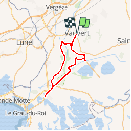
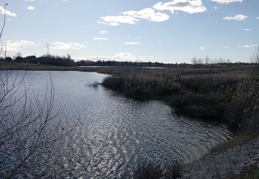
Tocht Fiets van 44 km beschikbaar op Occitanië, Gard, Vauvert. Deze tocht wordt voorgesteld door gmerminod.

Beschrijving

DE_TOUR_EN_TOUR_en_CAMARGUE_GARDOISE

Hoogteprofiel

POI's

POI Vauvert - Repère 2- Arrêt paysage. - Photo
gmerminod
POI Saint-Laurent-d'Aigouze - Repère 6 - Fin des bords du Canal du Rhône-à-Sète et itinéraire pour Aigues-Mortes. - Photo
gmerminod
SAINT-LAURENT-D'AIGOUZE 
POI Saint-Laurent-d'Aigouze - Repère 7 - Début du chemin rive nord du Vistre. - Photo
gmerminod
SAINT-LAURENT-D'AIGOUZE 
POI Saint-Laurent-d'Aigouze - Repère 8 - Entrée du chemin de Clapière. - Photo
gmerminod
SAINT-LAURENT-D'AIGOUZE 

Plaatsbepaling

Land:
France
Regio :
Occitanië
Departement/Provincie :
Gard
Gemeente :
Vauvert
Locatie:
Unknown
Vertrek:(Dec)
Vertrek:(UTM)
602874 ; 4838266 (31T) N.

Opmerkingen

Gelieve in te loggen om een commentaar of een beoordeling achter te laten


Wandeltochten in de omgeving

Tocht Stappen Vauvert - Vauvert - Villetelle - Photo
Stappen
RR31

Stappen

Medium
(1)
Vauvert, Occitanië, Gard, France
22 km | 23 km-effort
6h 51min
Neen
Tocht Stappen Vauvert - Vauvert Les escaliers  de verre - Photo
Stappen
Ptitjack30

Stappen

Gemakkelijk
(1)
Vauvert, Occitanië, Gard, France
7,1 km | 8,4 km-effort
1h 37min
Ja
Tocht Stappen Le Cailar - cailar-costieres-camargues - Photo
Stappen
v.rabot

Stappen

Medium
Le Cailar, Occitanië, Gard, France
20 km | 22 km-effort
4h 0min
Ja
Tocht Hybride fiets Vauvert - 2020-01-29_15h48m07_10922156-track-1580309276-692 - Photo
Hybride fiets
gadafo

Hybride fiets

Heel gemakkelijk
(1)
Vauvert, Occitanië, Gard, France
50 km | 52 km-effort
Onbekend
Ja
Tocht Stappen Beauvoisin - 30 BEAUVOISIN, promenade dans les Costières de Nîmes, Entre Pinèdes, vignes, mas et vergers  - Photo
Stappen
jeff66

Stappen

Medium
Beauvoisin, Occitanië, Gard, France
22 km | 25 km-effort
3h 51min
Ja
Tocht Stappen Vauvert - 30 VAUVERT - GR653 - chemin d'Arles - FRANQUEVAUX - d'un canal a l'autre - GALLICIAN  - ch. des Coquillons - Photo
Stappen
jeff66

Stappen

Moeilijk
Vauvert, Occitanië, Gard, France
28 km | 31 km-effort
5h 1min
Ja
Tocht Stappen Le Cailar - Le Cailar - Photo
Stappen
guyzinz

Stappen

Zeer moeilijk
Le Cailar, Occitanië, Gard, France
15,6 km | 16,8 km-effort
4h 3min
Ja
Tocht Stappen Vergèze - Étangs de Vergèze le 20 01 2023 - Photo
Stappen
jesusmarieclaire

Stappen

Heel gemakkelijk
Vergèze, Occitanië, Gard, France
7 km | 7,5 km-effort
1h 43min
Ja
Tocht Hybride fiets Beauvoisin - cailar canal bas rhone - Photo
Hybride fiets
GEHAN Alain

Hybride fiets

Gemakkelijk
Beauvoisin, Occitanië, Gard, France
33 km | 35 km-effort
3h 19min
Ja


Sluiten
Mijn abonnementen