Tocht Te voet Lanne - 2021-05-02 16:57:34 - Photo
 mitch1952
mitch1952

Gebruiker

© OpenStreetMap contributors
Lengte
Lengte
18,6 km
Max. hoogte
Max. hoogte
643 m
Positief hoogteverschil
492 m
Km-Effort
Km-Effort  
25 km
Min. hoogte
Min. hoogte
376 m
Negatief hoogteverschil
492 m
Boucle
Boucle
Ja
Datum van aanmaak :
2021-05-02 19:23:51.318
Laatste wijziging :
2022-06-08 13:27:10.724

(0 Bericht)

Te voet
Te voet
5h42
Moeilijkheid : Medium

Scan deze QR-code om de tocht te openen in de SityTrail-applicatie

Gratisgps-wandelapplicatie

Logo SityTrail SityTrail

IGN / Geografische instituten

SityTrail uit de App Store downloaden SityTrail uit Google Play downloaden

Logo SityTrail SityTrail World

De wereld gaat voor u open

SityTrail uit de App Store downloaden SityTrail uit Google Play downloaden SityTrail op Huawei AppGallery downloaden

Over ons

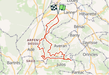
Tocht Te voet van 18,6 km beschikbaar op Occitanië, Hautes-Pyrénées, Lanne. Deze tocht wordt voorgesteld door mitch1952.

Beschrijving

IBP index 70 toujours selon IBP dénivelée trouvée 575m, prière d' en tenir compte

Hoogteprofiel

Plaatsbepaling

Land:
France
Regio :
Occitanië
Departement/Provincie :
Hautes-Pyrénées
Gemeente :
Lanne
Locatie:
Unknown
Vertrek:(Dec)
Vertrek:(UTM)
256313 ; 4783360 (31T) N.

Wandeltochten in de omgeving

Tocht Te voet Lanne - Le Chemin des Crêtes - Photo
Te voet
PRO

Te voet

Gemakkelijk
Lanne, Occitanië, Hautes-Pyrénées, France
11,4 km | 14,4 km-effort
3h 16min
Ja
Tocht Te voet Ossun - Les 3 Chapelles - Photo
Te voet
PRO

Te voet

Gemakkelijk
Ossun, Occitanië, Hautes-Pyrénées, France
10,9 km | 13,3 km-effort
3h 1min
Ja
Tocht Te voet Ossun - La Forêt d'Ossun - Photo
Te voet
PRO

Te voet

Gemakkelijk
Ossun, Occitanië, Hautes-Pyrénées, France
11,9 km | 15,3 km-effort
3h 29min
Ja
Tocht Andere activiteiten Lanne - Averan les crêtes court - Photo
Andere activiteiten
GIRAUDEL

Andere activiteiten

Gemakkelijk
(1)
Lanne, Occitanië, Hautes-Pyrénées, France
10 km | 12,6 km-effort
2h 20min
Ja
Tocht Noords wandelen Juillan - juillan hibarette louey  - Photo
Noords wandelen
Loucha

Noords wandelen

Heel gemakkelijk
Juillan, Occitanië, Hautes-Pyrénées, France
7,7 km | 9,6 km-effort
1h 38min
Ja
Tocht Stappen Orincles - Les chemins de Loucrup - Photo
Stappen
GIRAUDEL

Stappen

Gemakkelijk
Orincles, Occitanië, Hautes-Pyrénées, France
9,4 km | 12,5 km-effort
2h 49min
Ja
Tocht Te voet Barry - -Barry - Miramont - Photo
Te voet
mitch1952

Te voet

Gemakkelijk
Barry, Occitanië, Hautes-Pyrénées, France
9,9 km | 14,1 km-effort
3h 12min
Ja
Tocht Te voet Adé - G3 Ail des Ours et Miramont - Photo
Te voet
mitch1952

Te voet

Gemakkelijk
Adé, Occitanië, Hautes-Pyrénées, France
11,7 km | 16,7 km-effort
3h 48min
Ja
Tocht Te voet Lanne - 2021-04-16 16:42:06 - Photo
Te voet
mitch1952

Te voet

Medium
Lanne, Occitanië, Hautes-Pyrénées, France
21 km | 30 km-effort
6h 48min
Ja


Sluiten
Mijn abonnementen