Tocht Te voet Moncoutant-sur-Sèvre - rando du 23 mai 2021 - Photo
 dudu79
dudu79

Gebruiker

© OpenStreetMap contributors
Lengte
Lengte
21 km
Max. hoogte
Max. hoogte
241 m
Positief hoogteverschil
355 m
Km-Effort
Km-Effort  
26 km
Min. hoogte
Min. hoogte
123 m
Negatief hoogteverschil
355 m
Boucle
Boucle
Ja
Datum van aanmaak :
2021-05-24 08:35:28.183
Laatste wijziging :
2021-05-24 08:37:58.931

(0 Bericht)

Te voet
Te voet
5h54
Moeilijkheid : Medium

Scan deze QR-code om de tocht te openen in de SityTrail-applicatie

Gratisgps-wandelapplicatie

Logo SityTrail SityTrail

IGN / Geografische instituten

SityTrail uit de App Store downloaden SityTrail uit Google Play downloaden

Logo SityTrail SityTrail World

De wereld gaat voor u open

SityTrail uit de App Store downloaden SityTrail uit Google Play downloaden SityTrail op Huawei AppGallery downloaden

Over ons

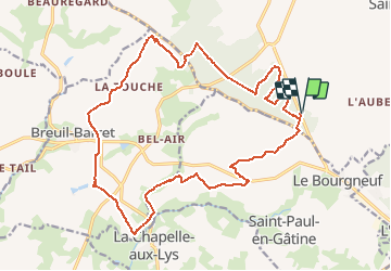
Tocht Te voet van 21 km beschikbaar op Nieuw-Aquitanië, Deux-Sèvres, Moncoutant-sur-Sèvre. Deze tocht wordt voorgesteld door dudu79.

Beschrijving

Avec Jean Marc et Catherine.

Hoogteprofiel

Plaatsbepaling

Land:
France
Regio :
Nieuw-Aquitanië
Departement/Provincie :
Deux-Sèvres
Gemeente :
Moncoutant-sur-Sèvre
Locatie:
La Chapelle-Saint-Étienne
Vertrek:(UTM)
682874 ; 5169947 (30T) N.

Wandeltochten in de omgeving

Tocht Te voet La Chapelle-aux-Lys - Chemin aux Étoiles - L'histoire de l'Univers - Photo
Te voet
PRO

Te voet

Gemakkelijk
La Chapelle-aux-Lys, Pays de la Loire, Vendée, France
4,3 km | 5,3 km-effort
1h 12min
Neen
Tocht Stappen Moncoutant-sur-Sèvre - Rando 17km A-R de la forêt de l'aventure - Photo
Stappen
dudu79

Stappen

Zeer moeilijk
(1)
Moncoutant-sur-Sèvre, Nieuw-Aquitanië, Deux-Sèvres, France
17,5 km | 21 km-effort
4h 50min
Ja
Tocht Stappen Moncoutant-sur-Sèvre - La Bonneliere - Photo
Stappen
Bushiben

Stappen

Heel gemakkelijk
Moncoutant-sur-Sèvre, Nieuw-Aquitanië, Deux-Sèvres, France
12,4 km | 14,2 km-effort
4h 59min
Ja
Tocht Stappen Moncoutant-sur-Sèvre - Chante merle - Photo
Stappen
viaul

Stappen

Gemakkelijk
Moncoutant-sur-Sèvre, Nieuw-Aquitanië, Deux-Sèvres, France
12,2 km | 14 km-effort
3h 4min
Ja
Tocht Stappen Moncoutant-sur-Sèvre - Forêt de l aventure  - Photo
Stappen
viaul

Stappen

Gemakkelijk
Moncoutant-sur-Sèvre, Nieuw-Aquitanië, Deux-Sèvres, France
19,8 km | 23 km-effort
5h 31min
Ja
Tocht Fiets Moncoutant-sur-Sèvre - Guérinière Bressuire 2 - Photo
Fiets
Ceclm

Fiets

Heel gemakkelijk
Moncoutant-sur-Sèvre, Nieuw-Aquitanië, Deux-Sèvres, France
19,3 km | 21 km-effort
1h 0min
Neen
Tocht Quad La Chapelle-aux-Lys - rando 7 oct 23 - Photo
Quad
rabal85

Quad

Heel gemakkelijk
La Chapelle-aux-Lys, Pays de la Loire, Vendée, France
85 km | 102 km-effort
3h 8min
Neen
Tocht Stappen Moncoutant-sur-Sèvre - Chante beau merle st Paul - Photo
Stappen
viaul

Stappen

Gemakkelijk
Moncoutant-sur-Sèvre, Nieuw-Aquitanië, Deux-Sèvres, France
18,3 km | 22 km-effort
4h 8min
Ja
Tocht 4x4 La Chapelle-aux-Lys - semi nocturne  - Photo
4x4
favraux

4x4

Heel gemakkelijk
La Chapelle-aux-Lys, Pays de la Loire, Vendée, France
108 km | 129 km-effort
15h 31min
Neen


Sluiten
Mijn abonnementen