Tocht Mountainbike Virton - Saint-Mard II  -  Balade_VTT_12kms  - Photo

Saint-Mard II - Balade_VTT_12kms

 Pascal L
Pascal L

Gebruiker

© OpenStreetMap contributors
Lengte
Lengte
12,2 km
Max. hoogte
Max. hoogte
274 m
Positief hoogteverschil
167 m
Km-Effort
Km-Effort  
14,4 km
Min. hoogte
Min. hoogte
199 m
Negatief hoogteverschil
169 m
Boucle
Boucle
Ja
Datum van aanmaak :
2021-06-16 16:18:34.382
Laatste wijziging :
2022-09-06 10:47:01.24

(0 Bericht)

Mountainbike
Mountainbike
35m
Moeilijkheid : Gemakkelijk

Scan deze QR-code om de tocht te openen in de SityTrail-applicatie

Gratisgps-wandelapplicatie

Logo SityTrail SityTrail

IGN / Geografische instituten

SityTrail uit de App Store downloaden SityTrail uit Google Play downloaden

Logo SityTrail SityTrail World

De wereld gaat voor u open

SityTrail uit de App Store downloaden SityTrail uit Google Play downloaden SityTrail op Huawei AppGallery downloaden

Over ons

Tocht Mountainbike van 12,2 km beschikbaar op Wallonië, Luxemburg, Virton. Deze tocht wordt voorgesteld door Pascal L.

Beschrijving

Départ/Retour: Saint-Mard (Centre Sportif)

Endroits de passage : Centre Hospitalier de Lorraine (Vivalia, CHL), Saint-Mard, les Aisances, la Viérine, Solumont, Ravel (ligne 155), Virton, Vieux-Virton

(2021.06.16)

Hoogteprofiel

Foto's

POI's

POI Virton - Golf Découverte Virton - Photo
Pascal L
POI Virton - Moulin Naisse à Virton - Photo
Pascal L

Plaatsbepaling

Land:
Belgium
Regio :
Wallonië
Departement/Provincie :
Luxemburg
Gemeente :
Virton
Locatie:
Unknown
Vertrek:(UTM)
682830 ; 5491328 (31U) N.

Wandeltochten in de omgeving

Tocht Stappen Virton - RB-Lu-17_Ethe_via-var-1-et-2-et-3 - Photo
Stappen
PRO

Stappen

Heel gemakkelijk
(3)
Virton, Wallonië, Luxemburg, Belgium
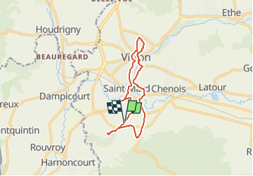
29 km | 35 km-effort
7h 33min
Ja
Tocht Stappen Rouvroy - Torgny. Natura 2000, des sites qui valent le détour. Lx5 - Photo
Stappen
GUIDE+

Stappen

Medium
(3)
Rouvroy, Wallonië, Luxemburg, Belgium
7,5 km | 11 km-effort
2h 18min
Ja
Tocht Mountainbike Virton - T2019-06-16-16-47 - Photo
Mountainbike
Pascal L

Mountainbike

Gemakkelijk
(1)
Virton, Wallonië, Luxemburg, Belgium
21 km | 26 km-effort
1h 40min
Ja
Tocht Stappen Virton - GAUME Balade  naturelle et historique - Photo
Stappen
julucasi

Stappen

Heel gemakkelijk
(1)
Virton, Wallonië, Luxemburg, Belgium
5,2 km | 6,8 km-effort
1h 16min
Ja
Tocht Te voet Virton - La Bajocienne - Photo
Te voet
GUIDE+

Te voet

Gemakkelijk
(1)
Virton, Wallonië, Luxemburg, Belgium
11 km | 14,5 km-effort
3h 17min
Ja
Tocht Te voet Virton - Chenois-Latour - Agrarische wandeling -  dorpen, appels en klein fruit - Photo
Te voet
GUIDE
DUPONT Rita

Te voet

Gemakkelijk
Virton, Wallonië, Luxemburg, Belgium
6,4 km | 7,7 km-effort
1h 45min
Ja
Tocht Stappen Rouvroy - RB-Lu-18_Torgny - Photo
Stappen
PRO

Stappen

Heel gemakkelijk
Rouvroy, Wallonië, Luxemburg, Belgium
21 km | 28 km-effort
5h 54min
Ja
Tocht Stappen Virton - RB-Lu-17_Ethe_via-racc - Photo
Stappen
PRO

Stappen

Heel gemakkelijk
Virton, Wallonië, Luxemburg, Belgium
15,6 km | 19,3 km-effort
4h 8min
Ja
Tocht Stappen Virton - RB-Lu-17_Ethe - Photo
Stappen
PRO

Stappen

Heel gemakkelijk
Virton, Wallonië, Luxemburg, Belgium
22 km | 28 km-effort
5h 55min
Ja


Sluiten
Mijn abonnementen