


a-griekenland-diakopto-griekenland

gpstracks
Gebruiker
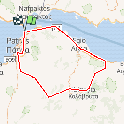

Lengte
127 km

Max. hoogte
1158 m

Positief hoogteverschil
8311 m
Km-Effort
238 km

Min. hoogte
-1 m

Negatief hoogteverschil
8312 m
Boucle
Ja
Datum van aanmaak :
2014-12-10 00:00:00.0
Laatste wijziging :
2014-12-10 00:00:00.0
--
Moeilijkheid : Onbekend

Gratisgps-wandelapplicatie
 SityTrail
IGN / Geografische instituten
SityTrail World
De wereld gaat voor u open
Over ons
Tocht Motor van 127 km beschikbaar op Peloponnesos, West-Griekenland en Ionische Eilanden, Περιφερειακή Ενότητα Αχαΐας, Δημοτική Ενότητα Ρίου. Deze tocht wordt voorgesteld door gpstracks.
Beschrijving
More information on GPStracks.nl : http://www.gpstracks.nl


Plaatsbepaling
Land:
Greece
Regio :
Peloponnesos, West-Griekenland en Ionische Eilanden
Departement/Provincie :
Περιφερειακή Ενότητα Αχαΐας
Gemeente :
Δημοτική Ενότητα Ρίου
Locatie:
Κοινότητα Ρίου
Vertrek:(Dec)
Vertrek:(UTM)
568093 ; 4240158 (34S) N.
Opmerkingen
Wandeltochten in de omgeving