Tocht Stappen Saint-Germain-lès-Buxy - Saint germain les Buxy La Forêt Muguet page 114 - Photo

Saint germain les Buxy La Forêt Muguet page 114

 grasgilbert
grasgilbert

Gebruiker

© OpenStreetMap contributors
Lengte
Lengte
13,8 km
Max. hoogte
Max. hoogte
231 m
Positief hoogteverschil
121 m
Km-Effort
Km-Effort  
15,4 km
Min. hoogte
Min. hoogte
190 m
Negatief hoogteverschil
122 m
Boucle
Boucle
Ja
Datum van aanmaak :
2021-11-24 17:50:12.535
Laatste wijziging :
2022-04-25 08:15:10.277

(4 Bericht)

Stappen
Stappen
3h41
Moeilijkheid : Moeilijk

Scan deze QR-code om de tocht te openen in de SityTrail-applicatie

Gratisgps-wandelapplicatie

Logo SityTrail SityTrail

IGN / Geografische instituten

SityTrail uit de App Store downloaden SityTrail uit Google Play downloaden

Logo SityTrail SityTrail World

De wereld gaat voor u open

SityTrail uit de App Store downloaden SityTrail uit Google Play downloaden SityTrail op Huawei AppGallery downloaden

Over ons

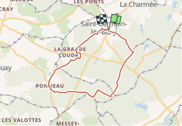
Tocht Stappen van 13,8 km beschikbaar op Bourgondië-Franche-Comté, Saône-et-Loire, Saint-Germain-lès-Buxy. Deze tocht wordt voorgesteld door grasgilbert.

Hoogteprofiel

Plaatsbepaling

Land:
France
Regio :
Bourgondië-Franche-Comté
Departement/Provincie :
Saône-et-Loire
Gemeente :
Saint-Germain-lès-Buxy
Locatie:
Unknown
Vertrek:(UTM)
635633 ; 5174257 (31T) N.

Opmerkingen

Gelieve in te loggen om een commentaar of een beoordeling achter te laten


bien


bien


Wandeltochten in de omgeving

Tocht Noords wandelen Sevrey - sevrey - Photo
Noords wandelen
patourad

Noords wandelen

Heel gemakkelijk
(1)
Sevrey, Bourgondië-Franche-Comté, Saône-et-Loire, France
9,7 km | 10,2 km-effort
1h 37min
Ja
Tocht Stappen La Charmée - la charmée - Photo
Stappen
tountouri

Stappen

Medium
La Charmée, Bourgondië-Franche-Comté, Saône-et-Loire, France
5,7 km | 6,2 km-effort
1h 17min
Neen
Tocht Stappen La Charmée - G . La Charmée Nord - Battrey - bois du temple - Le Piony - Mépilley et retour par champ Guenard . - Photo
Stappen
jeanpaulcheyssac

Stappen

Medium
La Charmée, Bourgondië-Franche-Comté, Saône-et-Loire, France
10,2 km | 11,3 km-effort
2h 33min
Ja
Tocht Stappen La Charmée - P . L a Charmée - Battrey - Les deux chenes - La Loge retourpar les Meix . - Photo
Stappen
jeanpaulcheyssac

Stappen

Medium
La Charmée, Bourgondië-Franche-Comté, Saône-et-Loire, France
10,1 km | 11,1 km-effort
2h 31min
Ja
Tocht Stappen Givry - P . Fontaine couverte Nord . - Photo
Stappen
jeanpaulcheyssac

Stappen

Medium
Givry, Bourgondië-Franche-Comté, Saône-et-Loire, France
9,1 km | 10,1 km-effort
2h 17min
Ja
Tocht Stappen Givry - P. Fontaines couverte Sud  - Photo
Stappen
jeanpaulcheyssac

Stappen

Medium
Givry, Bourgondië-Franche-Comté, Saône-et-Loire, France
7,2 km | 8,1 km-effort
1h 50min
Ja
Tocht Stappen Laives - G . Lacs de Laives - Beaumont - Laives et retour . - Photo
Stappen
jeanpaulcheyssac

Stappen

Moeilijk
Laives, Bourgondië-Franche-Comté, Saône-et-Loire, France
11,2 km | 12,3 km-effort
2h 47min
Ja
Tocht Stappen Chenôves - Les Valottes - Photo
Stappen
Papé TB

Stappen

Heel gemakkelijk
Chenôves, Bourgondië-Franche-Comté, Saône-et-Loire, France
11,1 km | 12,4 km-effort
2h 23min
Ja
Tocht Stappen Laives - Laives - lacs et ville - Photo
Stappen
PapyChalon

Stappen

Gemakkelijk
Laives, Bourgondië-Franche-Comté, Saône-et-Loire, France
12,6 km | 14 km-effort
Onbekend
Ja


Sluiten
Mijn abonnementen