Tocht Te voet Sohland an der Spree - LG-Sohland-Ringweg - Photo

Tous les sentiers balisés d’Europe PRO

© OpenStreetMap contributors
Lengte
Lengte
6,7 km
Max. hoogte
Max. hoogte
472 m
Positief hoogteverschil
160 m
Km-Effort
Km-Effort  
9,2 km
Min. hoogte
Min. hoogte
329 m
Negatief hoogteverschil
244 m
Boucle
Boucle
Neen
Markering
Markering
Datum van aanmaak :
2022-02-11 13:44:01.887
Laatste wijziging :
2022-02-11 13:44:01.887

(0 Bericht)

Te voet
Te voet
2h04
Moeilijkheid : Gemakkelijk

Scan deze QR-code om de tocht te openen in de SityTrail-applicatie

Gratisgps-wandelapplicatie

Logo SityTrail SityTrail

IGN / Geografische instituten

SityTrail uit de App Store downloaden SityTrail uit Google Play downloaden

Logo SityTrail SityTrail World

De wereld gaat voor u open

SityTrail uit de App Store downloaden SityTrail uit Google Play downloaden SityTrail op Huawei AppGallery downloaden

Over ons

Tocht Te voet van 6,7 km beschikbaar op Saksen, Bautzen, Sohland an der Spree. Deze tocht wordt voorgesteld door SityTrail - itinéraires balisés pédestres.

Beschrijving

Symbol: Gelber Punkt auf weißem Grund

Foto's

Plaatsbepaling

Land:
Germany
Regio :
Saksen
Departement/Provincie :
Bautzen
Gemeente :
Sohland an der Spree
Locatie:
Unknown
Vertrek:(UTM)
460353 ; 5653136 (33U) N.

Wandeltochten in de omgeving

Tocht Te voet Oppach - Ringweg Oppach - Photo
Te voet
PRO

Te voet

Gemakkelijk
Oppach, Saksen, Görlitz, Germany
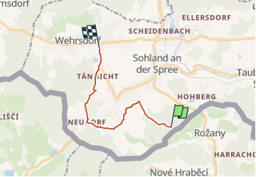
11,6 km | 14,8 km-effort
3h 22min
Ja
Tocht Te voet Sohland an der Spree - Planetenweg - Photo
Te voet
PRO

Te voet

Gemakkelijk
Sohland an der Spree, Saksen, Bautzen, Germany
4,3 km | 6 km-effort
1h 22min
Neen


Sluiten
Mijn abonnementen