


3,5 km | 4,7 km-effort

Tous les sentiers balisés d’Europe PRO


Gratisgps-wandelapplicatie
 SityTrail
IGN / Geografische instituten
SityTrail World
De wereld gaat voor u open
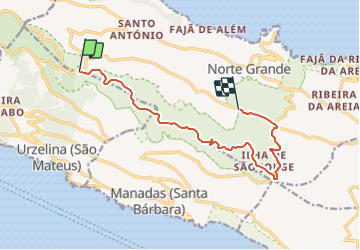
Tocht Te voet van 12,3 km beschikbaar op Azoren, Onbekend, Norte Grande (Neves). Deze tocht wordt voorgesteld door SityTrail - itinéraires balisés pédestres.
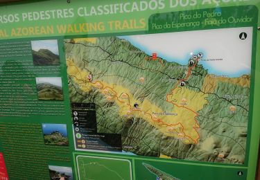
Discover the hiking route PR4SJO Pico do Pedro – Pico da Esperança – Fajã do Ouvidor. View the map and download the GPS track.
Website: http://trails.visitazores.com/en/trails-azores/sao-jorge/pico-do-pedro-pico-da-esperanca-faja-do-ouvidor
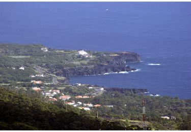
 - Pico do Pedro – Pico da Esperança – Fajã do Ouvidor - Photo 1")
 - Pico do Pedro – Pico da Esperança – Fajã do Ouvidor - Photo 2")
 - Pico do Pedro – Pico da Esperança – Fajã do Ouvidor - Photo 3")
 - Pico do Pedro – Pico da Esperança – Fajã do Ouvidor - Photo 4")
 - Pico do Pedro – Pico da Esperança – Fajã do Ouvidor - Photo 5")
 - Pico do Pedro – Pico da Esperança – Fajã do Ouvidor - Photo 6")
 - Pico do Pedro – Pico da Esperança – Fajã do Ouvidor - Photo 7")
 - Pico do Pedro – Pico da Esperança – Fajã do Ouvidor - Photo 8")
 - Pico do Pedro – Pico da Esperança – Fajã do Ouvidor - Photo 9")
 - Pico do Pedro – Pico da Esperança – Fajã do Ouvidor - Photo 10")
Te voet
Stappen

Stappen