Tocht Stappen Leukerbad - Birchen, Lee (Leukerbad) 13.06.14 - Photo

Birchen, Lee (Leukerbad) 13.06.14

 duamerg
duamerg

Gebruiker

© OpenStreetMap contributors
Lengte
Lengte
7,6 km
Max. hoogte
Max. hoogte
1779 m
Positief hoogteverschil
484 m
Km-Effort
Km-Effort  
14 km
Min. hoogte
Min. hoogte
1302 m
Negatief hoogteverschil
483 m
Boucle
Boucle
Ja
Datum van aanmaak :
2014-12-10 00:00:00.0
Laatste wijziging :
2020-01-30 13:57:03.244

(0 Bericht)

Stappen
Stappen
3h02
Moeilijkheid : Gemakkelijk

Scan deze QR-code om de tocht te openen in de SityTrail-applicatie

Gratisgps-wandelapplicatie

Logo SityTrail SityTrail

IGN / Geografische instituten

SityTrail uit de App Store downloaden SityTrail uit Google Play downloaden

Logo SityTrail SityTrail World

De wereld gaat voor u open

SityTrail uit de App Store downloaden SityTrail uit Google Play downloaden SityTrail op Huawei AppGallery downloaden

Over ons

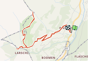
Tocht Stappen van 7,6 km beschikbaar op Valais/Wallis, Leuk, Leukerbad. Deze tocht wordt voorgesteld door duamerg.

Beschrijving

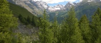
Impossible de s'arrêter à Loêche les bains sans avoir à payer pour un parking. S'arrêter un peu avant et suivre les panneaux Birchen. Suivre les panneaux pour Larschi. Traverser le torrent pour voir la belle cascade. Revenir un peu en arrière pour avoir un beau chemin (non marqué) qui vous mènera jusqu'au hameau de Lee avec une vue magnifique sur les alpes. Il y a normalement la possibilité par les hauts de faire un circuit qui vous ramène au hameau de Birchen (probablement 2 heures de marche en plus). Chemin impraticable suite à des avalanches qui ont mis à mal le chemin. Retour par le même chemin.
Jolie ballade avec les prairies tout en fleurs et une belle vue.

Hoogteprofiel

Foto's

POI's

POI Leukerbad - Belle petite chapelle - Photo
duamerg
POI Leukerbad - Restaurant - Photo
duamerg
LEUKERBAD 
POI Leukerbad - belle vue - Photo
duamerg
LEUKERBAD 
POI Inden - Cascade et flore - Photo
duamerg
POI Inden - chemin détruit - Photo
duamerg

Plaatsbepaling

Land:
Switzerland
Regio :
Valais/Wallis
Departement/Provincie :
Leuk
Gemeente :
Leukerbad
Locatie:
Unknown
Vertrek:(Dec)
Vertrek:(UTM)
393843 ; 5135630 (32T) N.

Wandeltochten in de omgeving

Tocht Te voet Albinen - Wanderweg Albinen-Leuk Station - Photo
Te voet
PRO

Te voet

Gemakkelijk
Albinen, Valais/Wallis, Leuk, Switzerland
5,5 km | 7,8 km-effort
1h 45min
Neen
Tocht Stappen Leukerbad - sf10_e9c - Photo
Stappen
GUIDE+

Stappen

Heel gemakkelijk
Leukerbad, Valais/Wallis, Leuk, Switzerland
17,8 km | 29 km-effort
6h 3min
Neen
Tocht Stappen Leukerbad - hike36 - Photo
Stappen
GUIDE+

Stappen

Heel gemakkelijk
Leukerbad, Valais/Wallis, Leuk, Switzerland
12,8 km | 26 km-effort
Onbekend
Neen
Tocht Stappen Leukerbad - st_gemmi - Photo
Stappen
GUIDE+

Stappen

Heel gemakkelijk
Leukerbad, Valais/Wallis, Leuk, Switzerland
12,3 km | 26 km-effort
2h 54min
Neen
Tocht Mountainbike Leukerbad - Gemmipass - Photo
Mountainbike
GUIDE+

Mountainbike

Heel gemakkelijk
Leukerbad, Valais/Wallis, Leuk, Switzerland
19,7 km | 29 km-effort
5h 40min
Ja
Tocht Stappen Albinen - vs_hike781d - Photo
Stappen
GUIDE+

Stappen

Heel gemakkelijk
Albinen, Valais/Wallis, Leuk, Switzerland
5,9 km | 14,6 km-effort
2h 15min
Ja
Tocht Stappen Leukerbad - vs_hike781c - Photo
Stappen
GUIDE+

Stappen

Heel gemakkelijk
Leukerbad, Valais/Wallis, Leuk, Switzerland
3,1 km | 5,5 km-effort
58min
Ja
Tocht Stappen Leukerbad - vs_hike781b - Photo
Stappen
GUIDE+

Stappen

Heel gemakkelijk
Leukerbad, Valais/Wallis, Leuk, Switzerland
12,9 km | 23 km-effort
4h 7min
Ja
Tocht Stappen Leukerbad - vs_hike781a - Photo
Stappen
GUIDE+

Stappen

Heel gemakkelijk
Leukerbad, Valais/Wallis, Leuk, Switzerland
5,1 km | 8,7 km-effort
1h 31min
Neen


Sluiten
Mijn abonnementen