Tocht Mountainbike Arth - Rigi - Photo

Optez pour le retour à la nature GUIDE+

© OpenStreetMap contributors
Lengte
Lengte
41 km
Max. hoogte
Max. hoogte
1763 m
Positief hoogteverschil
1847 m
Km-Effort
Km-Effort  
66 km
Min. hoogte
Min. hoogte
442 m
Negatief hoogteverschil
1848 m
Boucle
Boucle
Ja
Datum van aanmaak :
2014-12-10 00:00:00.0
Laatste wijziging :
2014-12-10 00:00:00.0

(0 Bericht)

Mountainbike
Mountainbike
13h28
Moeilijkheid : Onbekend

Scan deze QR-code om de tocht te openen in de SityTrail-applicatie

Gratisgps-wandelapplicatie

Logo SityTrail SityTrail

IGN / Geografische instituten

SityTrail uit de App Store downloaden SityTrail uit Google Play downloaden

Logo SityTrail SityTrail World

De wereld gaat voor u open

SityTrail uit de App Store downloaden SityTrail uit Google Play downloaden SityTrail op Huawei AppGallery downloaden

Over ons

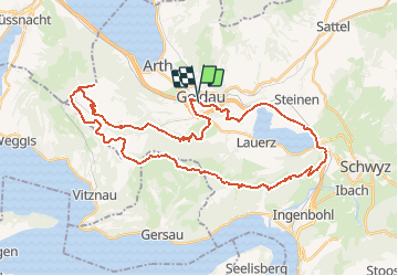
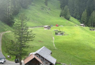
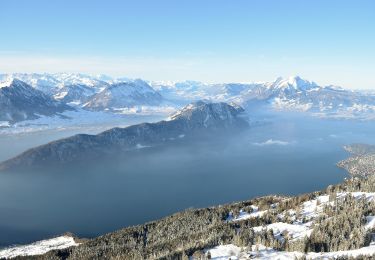
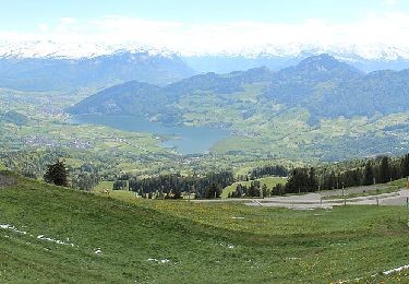
Tocht Mountainbike van 41 km beschikbaar op Schwyz, Schwyz, Arth. Deze tocht wordt voorgesteld door My Switzerland.

Hoogteprofiel

POI's

POI Arth - Station Fruttli - Photo
My Switzerland
POI Arth -  - Photo
My Switzerland
ARTH 
POI Arth - Rigi-Staffel - Photo
My Switzerland
POI Arth - Rigi-Kulm - Photo
My Switzerland
ARTH 
POI Arth - Rigi Staffel - Photo
My Switzerland
POI Arth - Rigi Kaltbad - Photo
My Switzerland
POI Gersau -  - Photo
My Switzerland
GERSAU 
POI Gersau - Gätterli - Photo
My Switzerland
GERSAU 
POI Arth - Bahnhof Arth-Goldau - Photo
My Switzerland
POI Arth - Bahnhof Arth-Goldau - Photo
My Switzerland

Plaatsbepaling

Land:
Switzerland
Regio :
Schwyz
Departement/Provincie :
Schwyz
Gemeente :
Arth
Locatie:
Unknown
Vertrek:(Dec)
Vertrek:(UTM)
465729 ; 5210744 (32T) N.

Wandeltochten in de omgeving

Tocht Te voet Vitznau - Vitznau - ? - Photo
Te voet
PRO

Te voet

Gemakkelijk
Vitznau, Luzern, Onbekend, Switzerland
3 km | 4,8 km-effort
1h 5min
Neen
Tocht Te voet Arth - Rigi Kulm - Dächli - Photo
Te voet
PRO

Te voet

Gemakkelijk
Arth, Schwyz, Schwyz, Switzerland
4 km | 6,6 km-effort
1h 29min
Neen
Tocht Te voet Arth - Gribsch - Steinerberg - Photo
Te voet
PRO

Te voet

Gemakkelijk
Arth, Schwyz, Schwyz, Switzerland
3,8 km | 5,3 km-effort
1h 12min
Neen
Tocht Te voet Unterägeri - Urzlenboden - Geissfaren - Photo
Te voet
PRO

Te voet

Gemakkelijk
Unterägeri, Zug, Onbekend, Switzerland
3,3 km | 4,5 km-effort
1h 0min
Neen
Tocht Te voet Arth - Hinder Dossen - Rigi Klösterli - Photo
Te voet
PRO

Te voet

Gemakkelijk
Arth, Schwyz, Schwyz, Switzerland
4,1 km | 6,8 km-effort
1h 32min
Neen
Tocht Te voet Unterägeri - CH-Wildspitz - Urzlenboden - Photo
Te voet
PRO

Te voet

Gemakkelijk
Unterägeri, Zug, Onbekend, Switzerland
3,2 km | 7,4 km-effort
1h 40min
Neen
Tocht Te voet Arth - Goldau-Dächli - Photo
Te voet
PRO

Te voet

Gemakkelijk
Arth, Schwyz, Schwyz, Switzerland
3,9 km | 8,1 km-effort
1h 50min
Neen
Tocht Te voet Arth - Parkplatz A4 - Ochsenchneu - Photo
Te voet
PRO

Te voet

Gemakkelijk
Arth, Schwyz, Schwyz, Switzerland
3,1 km | 7 km-effort
1h 35min
Neen
Tocht Stappen Steinerberg - sf10_e4b - Photo
Stappen
GUIDE+

Stappen

Heel gemakkelijk
Steinerberg, Schwyz, Schwyz, Switzerland
23 km | 45 km-effort
9h 9min
Neen


Sluiten
Mijn abonnementen