Tocht Stappen Asson - Le Pic du Monbula - Arthez d'Asson - Photo

Le Pic du Monbula - Arthez d'Asson

 tracegps
tracegps

Gebruiker

© OpenStreetMap contributors
Lengte
Lengte
11,3 km
Max. hoogte
Max. hoogte
1583 m
Positief hoogteverschil
1129 m
Km-Effort
Km-Effort  
26 km
Min. hoogte
Min. hoogte
461 m
Negatief hoogteverschil
1129 m
Boucle
Boucle
Ja
Datum van aanmaak :
2014-12-10 00:00:00.0
Laatste wijziging :
2014-12-10 00:00:00.0

(0 Bericht)

Stappen
Stappen
6h30
Moeilijkheid : Moeilijk

Scan deze QR-code om de tocht te openen in de SityTrail-applicatie

Gratisgps-wandelapplicatie

Logo SityTrail SityTrail

IGN / Geografische instituten

SityTrail uit de App Store downloaden SityTrail uit Google Play downloaden

Logo SityTrail SityTrail World

De wereld gaat voor u open

SityTrail uit de App Store downloaden SityTrail uit Google Play downloaden SityTrail op Huawei AppGallery downloaden

Over ons

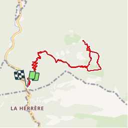
Tocht Stappen van 11,3 km beschikbaar op Nieuw-Aquitanië, Pyrénées-Atlantiques, Asson. Deze tocht wordt voorgesteld door tracegps.

Beschrijving

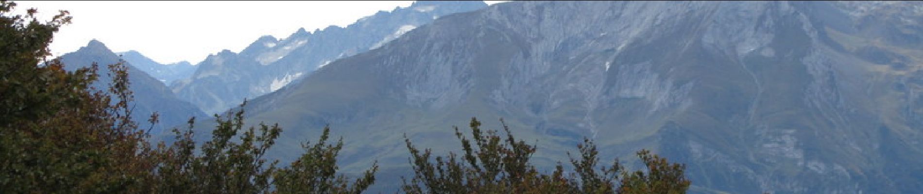
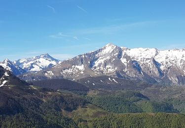
Départ sur la D126, 6km après Arthez-d'Asson en direction de Ferrières. Cela monte d'entrée pour aboutir dans un premier temps au Col d'Arangou. Puis on bifurque plein Est vers le plateau du Monbula pour attaquer ensuite la montée finale vers le Pic d'où le panorama est assez époustouflant. Descente par une variante jusqu'au plateau puis suivre le chemin de la montée et retrouver le parking.

Hoogteprofiel

Foto's

Plaatsbepaling

Land:
France
Regio :
Nieuw-Aquitanië
Departement/Provincie :
Pyrénées-Atlantiques
Gemeente :
Asson
Locatie:
Unknown
Vertrek:(Dec)
Vertrek:(UTM)
723192 ; 4768782 (30T) N.

Wandeltochten in de omgeving

Tocht Te voet Arbéost - SityTrail - Arbeost le tour des quartiers d'Arbeost fait - Photo
Te voet
GUIDE
marmotte65

Te voet

Gemakkelijk
(1)
Arbéost, Occitanië, Hautes-Pyrénées, France
6,7 km | 12,3 km-effort
Onbekend
Ja
Tocht Stappen Arbéost - Ferrière  - Photo
Stappen
pffrench

Stappen

Heel gemakkelijk
Arbéost, Occitanië, Hautes-Pyrénées, France
3,4 km | 5,7 km-effort
2h 1min
Ja
Tocht Stappen Arbéost - G3arbeost le tour fait 2022 - Photo
Stappen
LouisROGER

Stappen

Zeer moeilijk
Arbéost, Occitanië, Hautes-Pyrénées, France
7,1 km | 12,5 km-effort
4h 48min
Ja
Tocht Stappen Ferrières - FERRIERES  la mine de Baburet   295 0542 - Photo
Stappen
GUIDE
marmotte65

Stappen

Gemakkelijk
Ferrières, Occitanië, Hautes-Pyrénées, France
2,8 km | 4,8 km-effort
1h 2min
Ja
Tocht Stappen Aucun - pic d'estibet  - Photo
Stappen
Patlac3

Stappen

Moeilijk
Aucun, Occitanië, Hautes-Pyrénées, France
6,4 km | 13,3 km-effort
3h 35min
Ja
Tocht Te voet Ferrières - Circuit des mines de Baburet modifié - Photo
Te voet
GUIDE
marmotte65

Te voet

Medium
Ferrières, Occitanië, Hautes-Pyrénées, France
2,9 km | 4,9 km-effort
Onbekend
Ja
Tocht Stappen Ferrières - granquet - Photo
Stappen
dakar_88

Stappen

Heel gemakkelijk
Ferrières, Occitanië, Hautes-Pyrénées, France
9,1 km | 17,9 km-effort
6h 20min
Ja
Tocht Stappen Arbéost - Arbeost le tour des quartiers d'Arbeost fait - Photo
Stappen

Stappen

Gemakkelijk
Arbéost, Occitanië, Hautes-Pyrénées, France
7,5 km | 13,3 km-effort
3h 19min
Ja
Tocht Stappen Ferrières - Pic de l'Estibète - Photo
Stappen
2042

Stappen

Moeilijk
Ferrières, Occitanië, Hautes-Pyrénées, France
5,1 km | 11,1 km-effort
2h 14min
Neen


Sluiten
Mijn abonnementen