Tocht Lopen Eaux-Bonnes -  La Montagne Verte - Eaux Bonnes - Photo

La Montagne Verte - Eaux Bonnes

 tracegps
tracegps

Gebruiker

© OpenStreetMap contributors
Lengte
Lengte
11,1 km
Max. hoogte
Max. hoogte
1194 m
Positief hoogteverschil
553 m
Km-Effort
Km-Effort  
18,4 km
Min. hoogte
Min. hoogte
635 m
Negatief hoogteverschil
553 m
Boucle
Boucle
Ja
Datum van aanmaak :
2014-12-10 00:00:00.0
Laatste wijziging :
2014-12-10 00:00:00.0

(0 Bericht)

Lopen
Lopen
1h45
Moeilijkheid : Moeilijk

Scan deze QR-code om de tocht te openen in de SityTrail-applicatie

Gratisgps-wandelapplicatie

Logo SityTrail SityTrail

IGN / Geografische instituten

SityTrail uit de App Store downloaden SityTrail uit Google Play downloaden

Logo SityTrail SityTrail World

De wereld gaat voor u open

SityTrail uit de App Store downloaden SityTrail uit Google Play downloaden SityTrail op Huawei AppGallery downloaden

Over ons

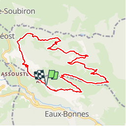
Tocht Lopen van 11,1 km beschikbaar op Nieuw-Aquitanië, Pyrénées-Atlantiques, Eaux-Bonnes. Deze tocht wordt voorgesteld door tracegps.

Beschrijving

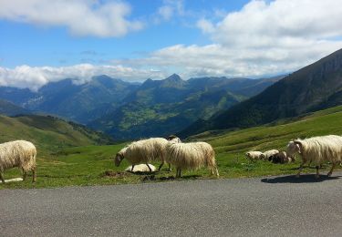
Départ: Aas, début du chemin de Pleysse. Elle porte bien son nom la Montagne Verte, ses pâturages restent verts même en été. Ce belvédère naturel offre un panorama sur la vallée des Eaux-Bonnes et le Pic du Ger. Téléchargez la fiche du circuit n°16 sur le site de la vallée d'Ossau. Crédit photos : Autres photos de janmorel .

Hoogteprofiel

Foto's

Plaatsbepaling

Land:
France
Regio :
Nieuw-Aquitanië
Departement/Provincie :
Pyrénées-Atlantiques
Gemeente :
Eaux-Bonnes
Locatie:
Unknown
Vertrek:(Dec)
Vertrek:(UTM)
712024 ; 4761888 (30T) N.

Wandeltochten in de omgeving

Tocht Stappen Béost - Behost - Photo
Stappen
swp648

Stappen

Gemakkelijk
(1)
Béost, Nieuw-Aquitanië, Pyrénées-Atlantiques, France
6 km | 9,9 km-effort
2h 59min
Ja
Tocht Stappen Laruns - LARUNS le tour du valentin G3
Stappen
GUIDE
marmotte65

Stappen

Moeilijk
Laruns, Nieuw-Aquitanië, Pyrénées-Atlantiques, France
8,2 km | 12,9 km-effort
2h 56min
Ja
Tocht Te voet Eaux-Bonnes - La promenade horizontale - Photo
Te voet
PRO

Te voet

Gemakkelijk
Eaux-Bonnes, Nieuw-Aquitanië, Pyrénées-Atlantiques, France
3,5 km | 5,3 km-effort
1h 12min
Ja
Tocht Te voet Eaux-Bonnes - Les thermes - Photo
Te voet
PRO

Te voet

Gemakkelijk
Eaux-Bonnes, Nieuw-Aquitanië, Pyrénées-Atlantiques, France
3,6 km | 5,9 km-effort
1h 20min
Ja
Tocht Te voet Laruns - L'eau - Photo
Te voet
PRO

Te voet

Gemakkelijk
Laruns, Nieuw-Aquitanië, Pyrénées-Atlantiques, France
4,8 km | 5,9 km-effort
1h 20min
Ja
Tocht Te voet Béost - Les crêtes d’Andreyt - Photo
Te voet
PRO

Te voet

Gemakkelijk
Béost, Nieuw-Aquitanië, Pyrénées-Atlantiques, France
9,6 km | 14,7 km-effort
3h 20min
Ja
Tocht Te voet Eaux-Bonnes - La montagne verte - Photo
Te voet
PRO

Te voet

Gemakkelijk
Eaux-Bonnes, Nieuw-Aquitanië, Pyrénées-Atlantiques, France
10,4 km | 17,8 km-effort
4h 2min
Ja
Tocht Te voet Louvie-Soubiron - Les carrières - Photo
Te voet
PRO

Te voet

Gemakkelijk
Louvie-Soubiron, Nieuw-Aquitanië, Pyrénées-Atlantiques, France
3,4 km | 7 km-effort
1h 35min
Ja
Tocht Te voet Béost - La promenade des trois villages - Photo
Te voet
PRO

Te voet

Gemakkelijk
Béost, Nieuw-Aquitanië, Pyrénées-Atlantiques, France
5,1 km | 8,6 km-effort
1h 56min
Ja


Sluiten
Mijn abonnementen