Tocht Stappen Fontpédrouse - fontpérouse sentier des canaux et sources chaudes naturelles_T - Photo

fontpérouse sentier des canaux et sources chaudes naturelles_T

 force
force

Gebruiker

© OpenStreetMap contributors
Lengte
Lengte
13,7 km
Max. hoogte
Max. hoogte
1500 m
Positief hoogteverschil
840 m
Km-Effort
Km-Effort  
25 km
Min. hoogte
Min. hoogte
1018 m
Negatief hoogteverschil
831 m
Boucle
Boucle
Ja
Datum van aanmaak :
2014-12-10 00:00:00.0
Laatste wijziging :
2014-12-10 00:00:00.0

(1 Bericht)

Stappen
Stappen
5h09
Moeilijkheid : Medium

Scan deze QR-code om de tocht te openen in de SityTrail-applicatie

Gratisgps-wandelapplicatie

Logo SityTrail SityTrail

IGN / Geografische instituten

SityTrail uit de App Store downloaden SityTrail uit Google Play downloaden

Logo SityTrail SityTrail World

De wereld gaat voor u open

SityTrail uit de App Store downloaden SityTrail uit Google Play downloaden SityTrail op Huawei AppGallery downloaden

Over ons

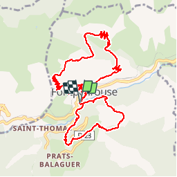
Tocht Stappen van 13,7 km beschikbaar op Occitanië, Pyrénées-Orientales, Fontpédrouse. Deze tocht wordt voorgesteld door force.

Hoogteprofiel

Foto's

Plaatsbepaling

Land:
France
Regio :
Occitanië
Departement/Provincie :
Pyrénées-Orientales
Gemeente :
Fontpédrouse
Locatie:
Unknown
Vertrek:(Dec)
Vertrek:(UTM)
432357 ; 4706644 (31T) N.

Opmerkingen

Gelieve in te loggen om een commentaar of een beoordeling achter te laten


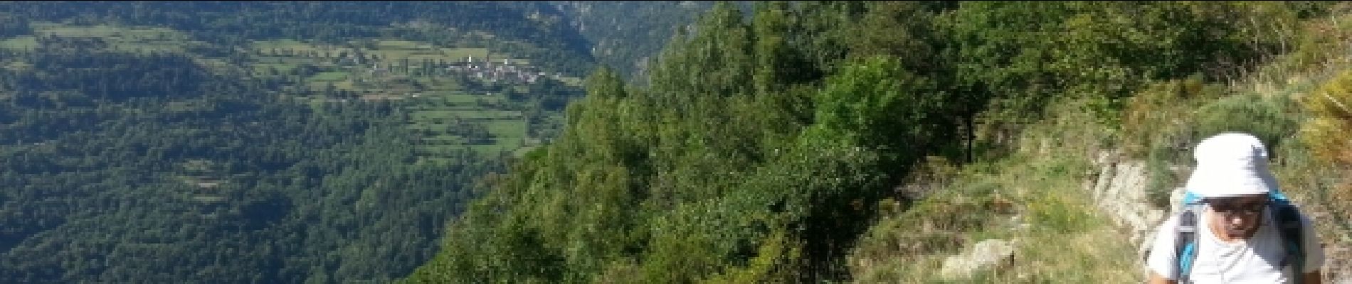
Par moment vertigineux .Aperçu du boulot formidable des anciens.


Wandeltochten in de omgeving

Tocht Stappen Thuès-Entre-Valls - boucle des gorges de Caranca - Photo
Stappen
PVERTICAL

Stappen

Medium
(2)
Thuès-Entre-Valls, Occitanië, Pyrénées-Orientales, France
7,2 km | 15,3 km-effort
3h 1min
Ja
Tocht Stappen Thuès-Entre-Valls - Gorges de la garanca - Photo
Stappen
attelageplaisir

Stappen

Heel gemakkelijk
(1)
Thuès-Entre-Valls, Occitanië, Pyrénées-Orientales, France
6,7 km | 13,1 km-effort
3h 39min
Neen
Tocht Stappen Fontpédrouse - Tour du Cucurucull - Photo
Stappen
Pek56

Stappen

Medium
(1)
Fontpédrouse, Occitanië, Pyrénées-Orientales, France
9,3 km | 18,5 km-effort
3h 24min
Ja
Tocht Stappen Planès - étang de Planès - Photo
Stappen
fhascoet

Stappen

Medium
(2)
Planès, Occitanië, Pyrénées-Orientales, France
10,8 km | 19,6 km-effort
3h 54min
Neen
Tocht Stappen Saint-Pierre-dels-Forcats - bains  de St Thomas  - Photo
Stappen
Ptitjack30

Stappen

Medium
(1)
Saint-Pierre-dels-Forcats, Occitanië, Pyrénées-Orientales, France
8,6 km | 12,2 km-effort
2h 42min
Neen
Tocht Stappen La Llagonne - llagonne - Calvet - Photo
Stappen
merencianoep

Stappen

Medium
(2)
La Llagonne, Occitanië, Pyrénées-Orientales, France
11,2 km | 14,2 km-effort
3h 0min
Neen
Tocht Stappen Thuès-Entre-Valls - Gorges de Carança - Photo
Stappen
ochamley

Stappen

Medium
(2)
Thuès-Entre-Valls, Occitanië, Pyrénées-Orientales, France
13,6 km | 30 km-effort
3h 43min
Ja
Tocht Stappen Fontpédrouse - Refuges Ras Carança - Ulldeter via col del Geant  - Photo
Stappen
chrisgps

Stappen

Medium
Fontpédrouse, Occitanië, Pyrénées-Orientales, France
8,9 km | 19 km-effort
6h 10min
Neen
Tocht Stappen Thuès-Entre-Valls - Gorges de  la Carança vers refuge - Photo
Stappen
chrisgps

Stappen

Medium
Thuès-Entre-Valls, Occitanië, Pyrénées-Orientales, France
9,8 km | 22 km-effort
5h 33min
Neen


Sluiten
Mijn abonnementen