Tocht Moto-cross Bérou-la-Mulotière - Randonnée Victor - Photo
 EricNormandie
EricNormandie

Gebruiker

© OpenStreetMap contributors
Lengte
Lengte
33 km
Max. hoogte
Max. hoogte
184 m
Positief hoogteverschil
361 m
Km-Effort
Km-Effort  
37 km
Min. hoogte
Min. hoogte
118 m
Negatief hoogteverschil
362 m
Boucle
Boucle
Neen
Datum van aanmaak :
2022-06-12 13:08:12.0
Laatste wijziging :
2022-06-12 15:45:44.97

(0 Bericht)

Moto-cross
Moto-cross
2h36
Moeilijkheid : Onbekend

Scan deze QR-code om de tocht te openen in de SityTrail-applicatie

Gratisgps-wandelapplicatie

Logo SityTrail SityTrail

IGN / Geografische instituten

SityTrail uit de App Store downloaden SityTrail uit Google Play downloaden

Logo SityTrail SityTrail World

De wereld gaat voor u open

SityTrail uit de App Store downloaden SityTrail uit Google Play downloaden SityTrail op Huawei AppGallery downloaden

Over ons

Tocht Moto-cross van 33 km beschikbaar op Centre-Val de Loire, Eure-et-Loir, Bérou-la-Mulotière. Deze tocht wordt voorgesteld door EricNormandie.

Beschrijving

Grimpettes

Hoogteprofiel

Plaatsbepaling

Land:
France
Regio :
Centre-Val de Loire
Departement/Provincie :
Eure-et-Loir
Gemeente :
Bérou-la-Mulotière
Locatie:
Unknown
Vertrek:(Dec)
Vertrek:(UTM)
360167 ; 5400327 (31U) N.

Wandeltochten in de omgeving

Tocht Stappen Acon - Circuit du château d'Hellenvilliers - Acon - Photo
Stappen
tracegps

Stappen

Moeilijk
Acon, Normandië, Eure, France
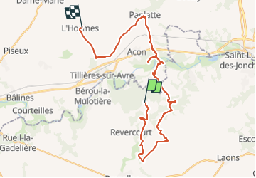
12,5 km | 13,7 km-effort
3h 10min
Ja
Tocht Stappen Acon - Vallée et Bois -  Acon - Photo
Stappen
tracegps

Stappen

Medium
Acon, Normandië, Eure, France
9,8 km | 11,8 km-effort
2h 30min
Ja
Tocht Stappen Acon - Avre et Meuvette - Acon - Photo
Stappen
tracegps

Stappen

Medium
Acon, Normandië, Eure, France
9 km | 10,3 km-effort
2h 15min
Ja
Tocht Mountainbike Tillières-sur-Avre - De Tillières sur Avre à Ormes - Photo
Mountainbike
tracegps

Mountainbike

Medium
Tillières-sur-Avre, Normandië, Eure, France
61 km | 68 km-effort
3h 30min
Neen
Tocht Stappen Acon - 2021_03_Autour de la Vallée d'Avre - Photo
Stappen
jeanlucien

Stappen

Gemakkelijk
Acon, Normandië, Eure, France
8,7 km | 10,5 km-effort
2h 5min
Ja
Tocht Te voet Breux-sur-Avre - Le Rousset d'Acon 19.50 - Photo
Te voet
togolo28

Te voet

Medium
Breux-sur-Avre, Normandië, Eure, France
19,5 km | 0 m-effort
Onbekend
Ja
Tocht Mountainbike Tillières-sur-Avre - tillieres sur avre - Photo
Mountainbike
nolouca

Mountainbike

Gemakkelijk
Tillières-sur-Avre, Normandië, Eure, France
30 km | 35 km-effort
2h 11min
Ja
Tocht Mountainbike Tillières-sur-Avre - autour de tillieres sur avre  - Photo
Mountainbike
nolouca

Mountainbike

Medium
Tillières-sur-Avre, Normandië, Eure, France
26 km | 29 km-effort
1h 40min
Ja
Tocht Mountainbike Tillières-sur-Avre - tillieres sur avre - Photo
Mountainbike
nolouca

Mountainbike

Medium
Tillières-sur-Avre, Normandië, Eure, France
25 km | 28 km-effort
1h 35min
Ja


Sluiten
Mijn abonnementen