


Sourbroodt 30 km

Alain Williaume
Gebruiker
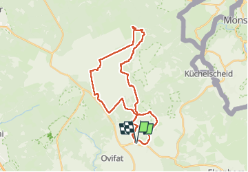

Lengte
29 km

Max. hoogte
700 m

Positief hoogteverschil
429 m
Km-Effort
35 km

Min. hoogte
515 m

Negatief hoogteverschil
430 m
Boucle
Ja
Datum van aanmaak :
2022-08-21 05:58:37.0
Laatste wijziging :
2022-08-21 12:05:45.049
5h54
Moeilijkheid : Zeer moeilijk

Gratisgps-wandelapplicatie
 SityTrail
IGN / Geografische instituten
SityTrail Plus
De wereld gaat voor u open
Over ons
Tocht Stappen van 29 km beschikbaar op Wallonië, Luik, Waimes. Deze tocht wordt voorgesteld door Alain Williaume.
Plaatsbepaling
Land:
Belgium
Regio :
Wallonië
Departement/Provincie :
Luik
Gemeente :
Waimes
Locatie:
Robertville
Vertrek:(Dec)
Vertrek:(UTM)
296494 ; 5595514 (32U) N.
Opmerkingen