Tocht Mountainbike Virton - Montourdon  -  Balade_VTT_26kms - Photo

Montourdon - Balade_VTT_26kms

 Pascal L
Pascal L

Gebruiker

© OpenStreetMap contributors
Lengte
Lengte
26 km
Max. hoogte
Max. hoogte
332 m
Positief hoogteverschil
459 m
Km-Effort
Km-Effort  
32 km
Min. hoogte
Min. hoogte
211 m
Negatief hoogteverschil
462 m
Boucle
Boucle
Ja
Datum van aanmaak :
2022-08-28 13:41:12.223
Laatste wijziging :
2022-11-16 18:27:22.118

(0 Bericht)

Mountainbike
Mountainbike
3h00
Moeilijkheid : Medium

Scan deze QR-code om de tocht te openen in de SityTrail-applicatie

Gratisgps-wandelapplicatie

Logo SityTrail SityTrail

IGN / Geografische instituten

SityTrail uit de App Store downloaden SityTrail uit Google Play downloaden

Logo SityTrail SityTrail World

De wereld gaat voor u open

SityTrail uit de App Store downloaden SityTrail uit Google Play downloaden SityTrail op Huawei AppGallery downloaden

Over ons

Tocht Mountainbike van 26 km beschikbaar op Wallonië, Luxemburg, Virton. Deze tocht wordt voorgesteld door Pascal L.

Beschrijving

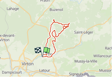
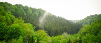
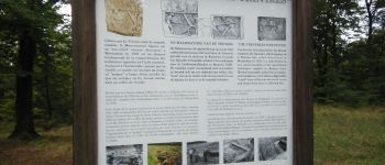
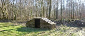
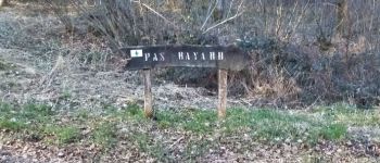
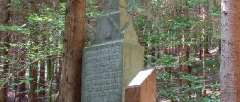
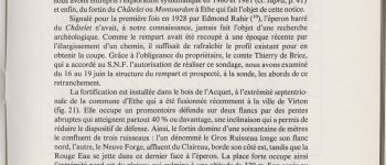
Cette balade vous conduit au coeur de la forêt entre Ethe, Buzenol et Saint-Léger, jusqu'à Montourdon, là où des résistants se cachaient et préparaient des opérations pendant la guerre en 1944. C'est aussi l'endroit où se trouve l'ancienne carrière de la Neuve Forge et l'éperon barré du Châtelet.

Départ/Retour: Virton (Belmont)
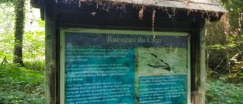
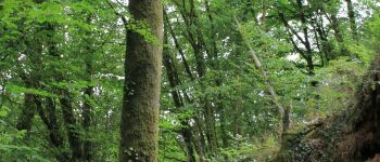
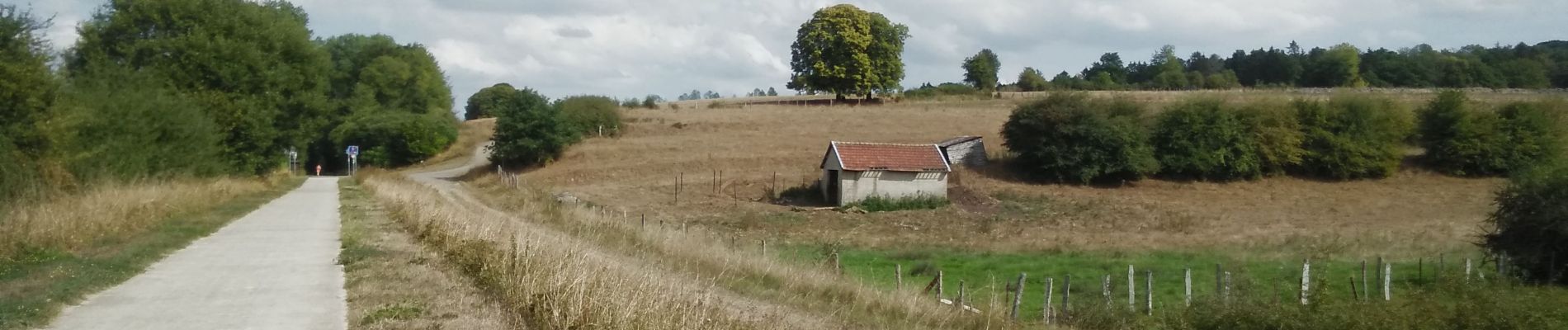
Endroits de passage : Ravel (ligne 155), Ethe, Fond de Bivau, le Bout de la Fin, Sablonnière, Ferme de Bar, le Cron et son ruisseau, ruisseau de la Neuve Forge, Vallée de Laclaireau, Bois de l'Acquêt, Montourdon (l'éperon barré du Châtelet et l'ancienne carrière de la Neuve Forge), panorama sur la vallée creusée par les ruisseaux Neuve Forge/Gros Ruisseau/Rouge Eau, le Cron de Montauban, Bois de Bar, Ourdon, le Chenois, ruisseau du Chou, Belmont

Vidéos (3):
1. https://vimeo.com/771630901 (le ruisseau du Cron)
2. https://vimeo.com/771642998 (allée dans le Bois de l'Acquêt)
3. https://vimeo.com/771646118 (panorama sur la vallée)

Ref.
- https://www.facebook.com/montourdon/
- https://oar.onroerenderfgoed.be/item/6131
- https://oar.onroerenderfgoed.be/publicaties/ARBE/247/ARBE247-011.pdf
- https://chemins.be/point-d-interet/12596-Ethe-pi-Carrière 'Le Châtelet'
- http://biodiversite.wallonie.be/nl/780-carriere-le-chatelet.html?IDD=251659464&IDC=1881
- http://biodiversite.wallonie.be/fr/6305-vallee-de-laclaireau.html?IDD=335545518&IDC=2831#
- http://biodiversite.wallonie.be/fr/780-carriere-le-chatelet.html?IDD=251659464&IDC=1881
- https://mapcarta.com/fr/W634248843/Carte
- https://docplayer.fr/20900694-Ravel-de-la-gaume-ligne-155.html
- https://www.lavenir.net/regions/luxembourg/virton/2018/10/22/montourdon-les-maquisards-en-gaume-se-racontent-CHQ5NHMT35EVHIWBFUPDABOARU/

(2022.08.28)

Hoogteprofiel

Foto's

92 fotos in totaal. Klik op een foto om ze allemaal in de galerij weer te geven.

POI's

POI Virton - Ruisseau du Cron - Photo
Pascal L
POI Virton - Château de Laclaireau - Photo
Pascal L
POI Virton - Unnamed POI - Photo
Pascal L
VIRTON 
POI Virton - Pas Bayard à Virton - Photo
Pascal L
POI Virton - Croix Renson - Photo
Pascal L
VIRTON 
POI Virton - Le Châtelet à Ethe - Photo
Pascal L

Plaatsbepaling

Land:
Belgium
Regio :
Wallonië
Departement/Provincie :
Luxemburg
Gemeente :
Virton
Locatie:
Unknown
Vertrek:(UTM)
685491 ; 5494824 (31U) N.

Wandeltochten in de omgeving

Tocht Stappen Virton - RB-Lu-17_Ethe_via-var-1-et-2-et-3 - Photo
Stappen
PRO

Stappen

Heel gemakkelijk
(3)
Virton, Wallonië, Luxemburg, Belgium
29 km | 35 km-effort
7h 33min
Ja
Tocht Mountainbike Virton - T2019-06-16-16-47 - Photo
Mountainbike
Pascal L

Mountainbike

Gemakkelijk
(1)
Virton, Wallonië, Luxemburg, Belgium
21 km | 26 km-effort
1h 40min
Ja
Tocht Stappen Virton - GAUME Balade  naturelle et historique - Photo
Stappen
julucasi

Stappen

Heel gemakkelijk
(1)
Virton, Wallonië, Luxemburg, Belgium
5,2 km | 6,8 km-effort
1h 16min
Ja
Tocht Te voet Virton - La Bajocienne - Photo
Te voet
GUIDE+

Te voet

Gemakkelijk
(1)
Virton, Wallonië, Luxemburg, Belgium
11 km | 14,5 km-effort
3h 17min
Ja
Tocht Te voet Virton - Chenois-Latour - Agrarische wandeling -  dorpen, appels en klein fruit - Photo
Te voet
GUIDE
DUPONT Rita

Te voet

Gemakkelijk
Virton, Wallonië, Luxemburg, Belgium
6,4 km | 7,7 km-effort
1h 45min
Ja
Tocht Stappen Virton - RB-Lu-17_Ethe_via-racc - Photo
Stappen
PRO

Stappen

Heel gemakkelijk
Virton, Wallonië, Luxemburg, Belgium
15,6 km | 19,3 km-effort
4h 8min
Ja
Tocht Stappen Virton - RB-Lu-17_Ethe - Photo
Stappen
PRO

Stappen

Heel gemakkelijk
Virton, Wallonië, Luxemburg, Belgium
22 km | 28 km-effort
5h 55min
Ja
Tocht Mountainbike Virton - Autour de Tintigny  -  Balade_VTT_54Kms - Photo
Mountainbike
Pascal L

Mountainbike

Zeer moeilijk
Virton, Wallonië, Luxemburg, Belgium
54 km | 64 km-effort
4h 25min
Ja
Tocht Mountainbike Virton - Monquintin  -  Balade_VTT_22Kms - Photo
Mountainbike
Pascal L

Mountainbike

Medium
Virton, Wallonië, Luxemburg, Belgium
22 km | 26 km-effort
1h 48min
Ja


Sluiten
Mijn abonnementen