Tocht Stappen Conamara Municipal District - Ballykine loop  - Photo
 M7184
M7184

Gebruiker

© OpenStreetMap contributors
Lengte
Lengte
7,2 km
Max. hoogte
Max. hoogte
41 m
Positief hoogteverschil
77 m
Km-Effort
Km-Effort  
8,2 km
Min. hoogte
Min. hoogte
18 m
Negatief hoogteverschil
78 m
Boucle
Boucle
Ja
Datum van aanmaak :
2022-09-09 13:17:27.598
Laatste wijziging :
2022-09-19 17:32:13.527

(0 Bericht)

Stappen
Stappen
1h52
Moeilijkheid : Heel gemakkelijk

Scan deze QR-code om de tocht te openen in de SityTrail-applicatie

Gratisgps-wandelapplicatie

Logo SityTrail SityTrail

IGN / Geografische instituten

SityTrail uit de App Store downloaden SityTrail uit Google Play downloaden

Logo SityTrail SityTrail World

De wereld gaat voor u open

SityTrail uit de App Store downloaden SityTrail uit Google Play downloaden SityTrail op Huawei AppGallery downloaden

Over ons

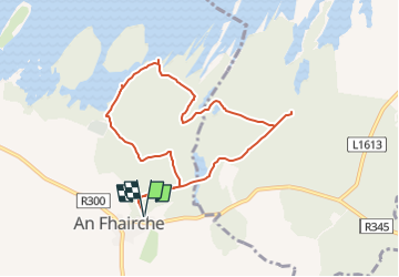
Tocht Stappen van 7,2 km beschikbaar op Onbekend, County Galway, Conamara Municipal District. Deze tocht wordt voorgesteld door M7184.

Beschrijving

An Fhairche
Parking aisé à côté de l'aire de jeu (Clonbur Wood car park), Aperçu de loin des ruines du Ballykine Castle et belles vue sur le lac "Lough Mask". Promenade facile,  chemin large et bien tracé

Hoogteprofiel

Foto's

Plaatsbepaling

Land:
Ireland
Regio :
Onbekend
Departement/Provincie :
County Galway
Gemeente :
Conamara Municipal District
Locatie:
Cloonbur ED
Vertrek:(UTM)
476071 ; 5933047 (29U) N.

Wandeltochten in de omgeving

Tocht Stappen Conamara Municipal District - cong - Photo
Stappen
bena42

Stappen

Heel gemakkelijk
Conamara Municipal District, Onbekend, County Galway, Ireland
3 km | 3,3 km-effort
46min
Neen


Sluiten
Mijn abonnementen