Tocht Stappen Vallière - Vallière-Pont des poupées - Photo

Vallière-Pont des poupées

 DanieleBocourt
DanieleBocourt

Gebruiker

© OpenStreetMap contributors
Lengte
Lengte
3,8 km
Max. hoogte
Max. hoogte
602 m
Positief hoogteverschil
93 m
Km-Effort
Km-Effort  
5 km
Min. hoogte
Min. hoogte
540 m
Negatief hoogteverschil
93 m
Boucle
Boucle
Ja
Datum van aanmaak :
2022-10-30 15:35:37.195
Laatste wijziging :
2022-10-30 17:05:56.007

(0 Bericht)

Stappen
Stappen
1h29
Moeilijkheid : Gemakkelijk

Scan deze QR-code om de tocht te openen in de SityTrail-applicatie

Gratisgps-wandelapplicatie

Logo SityTrail SityTrail

IGN / Geografische instituten

SityTrail uit de App Store downloaden SityTrail uit Google Play downloaden

Logo SityTrail SityTrail World

De wereld gaat voor u open

SityTrail uit de App Store downloaden SityTrail uit Google Play downloaden SityTrail op Huawei AppGallery downloaden

Over ons

Tocht Stappen van 3,8 km beschikbaar op Nieuw-Aquitanië, Creuse, Vallière. Deze tocht wordt voorgesteld door DanieleBocourt.

Hoogteprofiel

Plaatsbepaling

Land:
France
Regio :
Nieuw-Aquitanië
Departement/Provincie :
Creuse
Gemeente :
Vallière
Locatie:
Unknown
Vertrek:(UTM)
425147 ; 5084117 (31T) N.

Wandeltochten in de omgeving

Tocht Stappen Vallière - valliete - Photo
Stappen
Martin Cassol

Stappen

Medium
Vallière, Nieuw-Aquitanië, Creuse, France
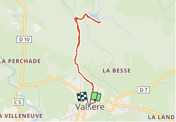
10,8 km | 13,4 km-effort
2h 38min
Ja
Tocht Stappen Vallière - Étang de Chabassière - Photo
Stappen
martinjacque

Stappen

Heel gemakkelijk
Vallière, Nieuw-Aquitanië, Creuse, France
4,8 km | 5,5 km-effort
2h 0min
Ja
Tocht Te voet Vallière - Rando dite
Te voet
Surot

Te voet

Gemakkelijk
(1)
Vallière, Nieuw-Aquitanië, Creuse, France
10,6 km | 13,4 km-effort
3h 2min
Ja
Tocht Stappen Banize - Banize à Le Villard / Etape 2 - Photo
Stappen
aucamus

Stappen

Zeer moeilijk
Banize, Nieuw-Aquitanië, Creuse, France
26 km | 33 km-effort
7h 28min
Neen
Tocht Stappen Banize - Banize / Bourganeuf (Millevaches) étape 2 - Photo
Stappen
aucamus

Stappen

Zeer moeilijk
Banize, Nieuw-Aquitanië, Creuse, France
30 km | 38 km-effort
8h 36min
Neen
Tocht Stappen Banize - GR4-55 - Banize - Chignat - Photo
Stappen
Tournan

Stappen

Zeer moeilijk
Banize, Nieuw-Aquitanië, Creuse, France
22 km | 28 km-effort
6h 5min
Neen
Tocht Stappen Banize - GR46-02 - Banize - Faux la Montagne - Photo
Stappen
Tournan

Stappen

Medium
Banize, Nieuw-Aquitanië, Creuse, France
30 km | 38 km-effort
8h 7min
Neen


Sluiten
Mijn abonnementen