Tocht Stappen Aigurande - Nature, verdure, bouchures - Photo

Nature, verdure, bouchures

 fanthou
fanthou

Gebruiker

© OpenStreetMap contributors
Lengte
Lengte
4,3 km
Max. hoogte
Max. hoogte
441 m
Positief hoogteverschil
81 m
Km-Effort
Km-Effort  
5,4 km
Min. hoogte
Min. hoogte
365 m
Negatief hoogteverschil
82 m
Boucle
Boucle
Ja
Datum van aanmaak :
2022-12-22 17:33:18.795
Laatste wijziging :
2022-12-22 17:34:38.828

(0 Bericht)

Stappen
Stappen
1h13
Moeilijkheid : Gemakkelijk

Scan deze QR-code om de tocht te openen in de SityTrail-applicatie

Gratisgps-wandelapplicatie

Logo SityTrail SityTrail

IGN / Geografische instituten

SityTrail uit de App Store downloaden SityTrail uit Google Play downloaden

Logo SityTrail SityTrail World

De wereld gaat voor u open

SityTrail uit de App Store downloaden SityTrail uit Google Play downloaden SityTrail op Huawei AppGallery downloaden

Over ons

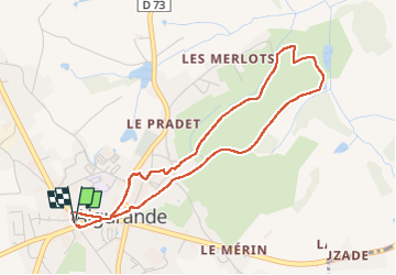
Tocht Stappen van 4,3 km beschikbaar op Centre-Val de Loire, Indre, Aigurande. Deze tocht wordt voorgesteld door fanthou.

Beschrijving

Au hasard des pas : église, puits, fontaines, maisons humbles ou de maître, croix témoignent des histoires du passé.

Hoogteprofiel

POI's

POI Aigurande -  - Photo
fanthou
AIGURANDE 
POI Aigurande -  - Photo
fanthou
AIGURANDE 
POI Aigurande -  - Photo
fanthou
AIGURANDE 
POI Aigurande -  - Photo
fanthou
AIGURANDE 
POI Aigurande -  - Photo
fanthou
AIGURANDE 
POI Aigurande -  - Photo
fanthou
AIGURANDE 
POI Aigurande -  - Photo
fanthou
AIGURANDE 

Plaatsbepaling

Land:
France
Regio :
Centre-Val de Loire
Departement/Provincie :
Indre
Gemeente :
Aigurande
Locatie:
Unknown
Vertrek:(UTM)
409807 ; 5142935 (31T) N.

Wandeltochten in de omgeving

Tocht Stappen Méasnes - Circuit de sources - Méasnes - Photo
Stappen
tracegps

Stappen

Medium
Méasnes, Nieuw-Aquitanië, Creuse, France
12 km | 14,5 km-effort
1h 30min
Ja
Tocht Stappen Aigurande - Circuit pédestre
Stappen
fanthou

Stappen

Medium
Aigurande, Centre-Val de Loire, Indre, France
7,7 km | 9,3 km-effort
2h 7min
Ja
Tocht Stappen Aigurande - Aigurande Seuvy St Sépulcre  - Photo
Stappen
Estéban MANZANO

Stappen

Zeer moeilijk
Aigurande, Centre-Val de Loire, Indre, France
19,1 km | 21 km-effort
6h 26min
Neen
Tocht Stappen Aigurande - SityTrail - aigurande ,la Vau vre - Photo
Stappen
GUIDE
jeanmarcMasson

Stappen

Moeilijk
Aigurande, Centre-Val de Loire, Indre, France
12,3 km | 15,4 km-effort
3h 30min
Ja
Tocht Stappen Aigurande - SityTrail - aigurande ,la Vau vre - Photo
Stappen
fanthou

Stappen

Gemakkelijk
Aigurande, Centre-Val de Loire, Indre, France
5,6 km | 6,9 km-effort
1h 33min
Ja
Tocht Stappen Méasnes - Circuit ME1 : Circuit du Bourg - Photo
Stappen
fanthou

Stappen

Gemakkelijk
Méasnes, Nieuw-Aquitanië, Creuse, France
4,8 km | 6 km-effort
1h 21min
Ja
Tocht Stappen Méasnes - Circuit ME2 : Circuit des Sources - Photo
Stappen
fanthou

Stappen

Medium
Méasnes, Nieuw-Aquitanië, Creuse, France
13,8 km | 17,1 km-effort
3h 52min
Ja
Tocht Stappen Lourdoueix-Saint-Pierre - Circuit LSP4 : Circuit de la Font du Beau - Photo
Stappen
fanthou

Stappen

Medium
Lourdoueix-Saint-Pierre, Nieuw-Aquitanië, Creuse, France
22 km | 25 km-effort
5h 47min
Ja
Tocht Te voet Lourdoueix-Saint-Pierre - Circuit LSP1 : Circuit de la Taille Minaud - Photo
Te voet
fanthou

Te voet

Gemakkelijk
Lourdoueix-Saint-Pierre, Nieuw-Aquitanië, Creuse, France
6,5 km | 7,5 km-effort
1h 42min
Ja


Sluiten
Mijn abonnementen