![](/images/other/stat-length.png)
![Tocht Stappen Barbières - Barbieres sources de la barberolle - Photo](https://media.geolcdn.com/t/1900/400/ext.pjpeg?maxdim=2&url=https%3A%2F%2Fstatic1.geolcdn.com%2Fsiteimages%2Fupload%2Ffiles%2F1553511878bg_sport_marche.png)
Barbieres sources de la barberolle
Danielle07
Gebruiker
![Lengte](/images/other/stat-length.png)
Lengte
14,3 km
![Max. hoogte](https://static1.geolcdn.com/siteimages/upload/files/1508320355ic_sort_altitude_max_24dp.png)
Max. hoogte
831 m
![Positief hoogteverschil](https://static1.geolcdn.com/siteimages/upload/files/1508320355ic_sort_den_pos_24dp.png)
Positief hoogteverschil
576 m
![Km-Effort](/images/other/stat-length.png)
Km-Effort
22 km
![Min. hoogte](https://static1.geolcdn.com/siteimages/upload/files/1508320355ic_sort_altitude_min_24dp.png)
Min. hoogte
422 m
![Negatief hoogteverschil](https://static1.geolcdn.com/siteimages/upload/files/1508320355ic_sort_den_neg_24dp.png)
Negatief hoogteverschil
576 m
![Boucle](https://static1.geolcdn.com/siteimages/upload/files/16400158638029165_repeat_loop_refresh_sync_direction_icon.png)
Boucle
Ja
Datum van aanmaak :
2023-03-30 07:24:13.636
Laatste wijziging :
2023-04-03 10:10:48.25
![Stappen](https://static1.geolcdn.com/sitytour/trail-icons/101.png)
5h00
Moeilijkheid : Zeer moeilijk
![Scan deze QR-code om de tocht te openen in de SityTrail-applicatie](https://capi.geolives.com/qq0zvz2zws4bq2lad0pu/sitytour/trails/3603851/qr.png?size=200)
Gratisgps-wandelapplicatie
Over ons
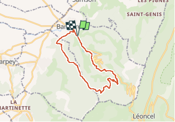
Tocht Stappen van 14,3 km beschikbaar op Auvergne-Rhône-Alpes, Drôme, Barbières. Deze tocht wordt voorgesteld door Danielle07.
Beschrijving
descente qui évite la grosse piste, visite des jardins de Barbières à la fin, bel espace de pique nique indiqué par un point d'interet
Plaatsbepaling
Land:
France
Regio :
Auvergne-Rhône-Alpes
Departement/Provincie :
Drôme
Gemeente :
Barbières
Locatie:
Unknown
Vertrek:(Dec)
Vertrek:(UTM)
669252 ; 4979778 (31T) N.
Opmerkingen
Wandeltochten in de omgeving
![Tocht Stappen Beauregard-Baret - Pré de Cinq Sous - Beauregard Baret - Photo](https://media.geolcdn.com/t/375/260/ext.jpg?maxdim=2&url=https%3A%2F%2Fservices.sitytrail.com%2FGeolivesWS%2FDownloadMedia.ashx%3FTrailID%3D214828%26Media%3D15342_3.jpg)
![Stappen Stappen](https://static1.geolcdn.com/sitytour/trail-icons/101.png)
Pré de Cinq Sous - Beauregard Baret
Stappen
Medium
(1)
Beauregard-Baret,
Auvergne-Rhône-Alpes,
Drôme,
France
![](/images/other/stat-length.png)
11,6 km | 23 km-effort
5h 0min
![](https://static1.geolcdn.com/siteimages/upload/files/16400158638029165_repeat_loop_refresh_sync_direction_icon.png)
Ja
![Tocht Stappen Rochefort-Samson - Les Vachères - Combe d'oyans - Photo](https://media.geolcdn.com/t/375/260/ext.jpg?maxdim=2&url=https%3A%2F%2Fmedia.geolcdn.com%2Ff%2Fb496d0d5-f9c5-4087-8105-422c092be197.jpg)
![Stappen Stappen](https://static1.geolcdn.com/sitytour/trail-icons/101.png)
Les Vachères - Combe d'oyans
Stappen
Moeilijk
(1)
Rochefort-Samson,
Auvergne-Rhône-Alpes,
Drôme,
France
![](/images/other/stat-length.png)
17,1 km | 28 km-effort
8h 26min
![](https://static1.geolcdn.com/siteimages/upload/files/16400158638029165_repeat_loop_refresh_sync_direction_icon.png)
Ja
![Tocht Stappen Saint-Vincent-la-Commanderie - Pierre Chauve 1308m, les Roches de Treillaras, depuis les Condamines - Photo](https://media.geolcdn.com/t/375/260/ext.jpg?maxdim=2&url=https%3A%2F%2Fservices.sitytrail.com%2FGeolivesWS%2FDownloadMedia.ashx%3FTrailID%3D318111%26Media%3D17572_1.jpg)
![Stappen Stappen](https://static1.geolcdn.com/sitytour/trail-icons/101.png)
Pierre Chauve 1308m, les Roches de Treillaras, depuis les Condamines
Stappen
Medium
(2)
Saint-Vincent-la-Commanderie,
Auvergne-Rhône-Alpes,
Drôme,
France
![](/images/other/stat-length.png)
12,7 km | 25 km-effort
6h 30min
![](https://static1.geolcdn.com/siteimages/upload/files/16400158638029165_repeat_loop_refresh_sync_direction_icon.png)
Ja
![Tocht Stappen Léoncel - Pierre Chauve depuis le Col de Tourniol - Photo](https://media.geolcdn.com/t/375/260/ext.jpg?maxdim=2&url=https%3A%2F%2Fstatic1.geolcdn.com%2Fsiteimages%2Fupload%2Ffiles%2F1553511878bg_sport_marche.png)
![Stappen Stappen](https://static1.geolcdn.com/sitytour/trail-icons/101.png)
Pierre Chauve depuis le Col de Tourniol
Stappen
Gemakkelijk
(3)
Léoncel,
Auvergne-Rhône-Alpes,
Drôme,
France
![](/images/other/stat-length.png)
7,9 km | 12,3 km-effort
2h 52min
![](https://static1.geolcdn.com/siteimages/upload/files/16400158638029165_repeat_loop_refresh_sync_direction_icon.png)
Ja
![Tocht Mountainbike Léoncel - Tête de la Dame - Photo](https://media.geolcdn.com/t/375/260/ext.jpg?maxdim=2&url=https%3A%2F%2Fstatic1.geolcdn.com%2Fsiteimages%2Fupload%2Ffiles%2F1524743154velo.jpg)
![Mountainbike Mountainbike](https://static1.geolcdn.com/sitytour/trail-icons/202.png)
Tête de la Dame
Mountainbike
Medium
(1)
Léoncel,
Auvergne-Rhône-Alpes,
Drôme,
France
![](/images/other/stat-length.png)
27 km | 39 km-effort
2h 35min
![](https://static1.geolcdn.com/siteimages/upload/files/16400158638029165_repeat_loop_refresh_sync_direction_icon.png)
Ja
![Tocht Stappen Barbières - Traversée Barbières Beauregard-Baret - Photo](https://media.geolcdn.com/t/375/260/ext.jpg?maxdim=2&url=https%3A%2F%2Fmedia.geolcdn.com%2Ff%2F2a3121e4-a036-4b19-8247-21a832e98ad8.jpg)
![Stappen Stappen](https://static1.geolcdn.com/sitytour/trail-icons/101.png)
Traversée Barbières Beauregard-Baret
Stappen
Zeer moeilijk
Barbières,
Auvergne-Rhône-Alpes,
Drôme,
France
![](/images/other/stat-length.png)
17 km | 28 km-effort
7h 9min
![](https://static1.geolcdn.com/siteimages/upload/files/16400158638029165_repeat_loop_refresh_sync_direction_icon.png)
Neen
![Tocht Stappen Saint-Vincent-la-Commanderie - 26 st Vincent commanderie zel - Photo](https://media.geolcdn.com/t/375/260/ext.jpg?maxdim=2&url=https%3A%2F%2Fmedia.geolcdn.com%2Ff%2F64d0078a-2be9-41db-957b-395e9e3d9a48.jpg)
![Stappen Stappen](https://static1.geolcdn.com/sitytour/trail-icons/101.png)
26 st Vincent commanderie zel
Stappen
Gemakkelijk
Saint-Vincent-la-Commanderie,
Auvergne-Rhône-Alpes,
Drôme,
France
![](/images/other/stat-length.png)
14,2 km | 22 km-effort
6h 5min
![](https://static1.geolcdn.com/siteimages/upload/files/16400158638029165_repeat_loop_refresh_sync_direction_icon.png)
Ja
![Tocht Stappen Barbières - Barbière Pierre Chauve - Photo](https://media.geolcdn.com/t/375/260/ext.jpg?maxdim=2&url=https%3A%2F%2Fmedia.geolcdn.com%2Ff%2Fb5c4b670-ee6c-4a0e-aa95-b9916d73aca5.jpg)
![Stappen Stappen](https://static1.geolcdn.com/sitytour/trail-icons/101.png)
Barbière Pierre Chauve
Stappen
Medium
Barbières,
Auvergne-Rhône-Alpes,
Drôme,
France
![](/images/other/stat-length.png)
8,1 km | 15,5 km-effort
2h 25min
![](https://static1.geolcdn.com/siteimages/upload/files/16400158638029165_repeat_loop_refresh_sync_direction_icon.png)
Ja
![Tocht Stappen Léoncel - Pas de Sausse pas De Chovet, arche de Rucla - Photo](https://media.geolcdn.com/t/375/260/ext.jpg?maxdim=2&url=https%3A%2F%2Fmedia.geolcdn.com%2Ff%2Fa074f09f-a40c-4153-b6a5-827bd1c5fffa.jpg)
![Stappen Stappen](https://static1.geolcdn.com/sitytour/trail-icons/101.png)
Pas de Sausse pas De Chovet, arche de Rucla
Stappen
Medium
Léoncel,
Auvergne-Rhône-Alpes,
Drôme,
France
![](/images/other/stat-length.png)
9,9 km | 14,6 km-effort
2h 43min
![](https://static1.geolcdn.com/siteimages/upload/files/16400158638029165_repeat_loop_refresh_sync_direction_icon.png)
Ja