Tocht Lopen Staten Island - TP-GPX-Marathon-de-New-York - Photo

TP-GPX-Marathon-de-New-York

 Doubotis
Doubotis

Gebruiker ADMIN

© OpenStreetMap contributors
Lengte
Lengte
43 km
Max. hoogte
Max. hoogte
49 m
Positief hoogteverschil
522 m
Km-Effort
Km-Effort  
50 km
Min. hoogte
Min. hoogte
-8 m
Negatief hoogteverschil
520 m
Boucle
Boucle
Neen
Datum van aanmaak :
2023-03-31 14:10:23.861
Laatste wijziging :
2023-03-31 14:11:05.3

(0 Bericht)

Lopen
Lopen
--
Moeilijkheid : Onbekend

Scan deze QR-code om de tocht te openen in de SityTrail-applicatie

Gratisgps-wandelapplicatie

Logo SityTrail SityTrail

IGN / Geografische instituten

SityTrail uit de App Store downloaden SityTrail uit Google Play downloaden

Logo SityTrail SityTrail World

De wereld gaat voor u open

SityTrail uit de App Store downloaden SityTrail uit Google Play downloaden SityTrail op Huawei AppGallery downloaden

Over ons

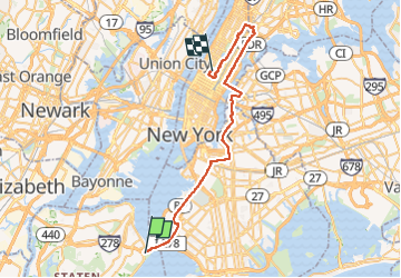
Tocht Lopen van 43 km beschikbaar op New York, Richmond County, Staten Island. Deze tocht wordt voorgesteld door Doubotis.

Hoogteprofiel

Plaatsbepaling

Land:
United States
Regio :
New York
Departement/Provincie :
Richmond County
Gemeente :
Staten Island
Locatie:
Unknown
Vertrek:(UTM)
579568 ; 4495018 (18T) N.

Wandeltochten in de omgeving

Tocht Lopen Staten Island - activity_944990220 1 - Photo
Lopen
chdubois

Lopen

Zeer moeilijk
Staten Island, New York, Richmond County, United States
43 km | 50 km-effort
Onbekend
Neen


Sluiten
Mijn abonnementen