Tocht Mountainbike Sainte-Ode - Houmont - Circuit VTT (1) des Haies de Magery  - Photo

Houmont - Circuit VTT (1) des Haies de Magery

Randonnées de la Grande Forêt de Saint-Hubert GUIDE+

© OpenStreetMap contributors
Lengte
Lengte
17 km
Max. hoogte
Max. hoogte
531 m
Positief hoogteverschil
299 m
Km-Effort
Km-Effort  
21 km
Min. hoogte
Min. hoogte
412 m
Negatief hoogteverschil
298 m
Boucle
Boucle
Ja
Datum van aanmaak :
2017-10-03 00:00:00.0
Laatste wijziging :
2017-10-03 00:00:00.0

(0 Bericht)

Mountainbike
Mountainbike
1h22
Moeilijkheid : Gemakkelijk

Scan deze QR-code om de tocht te openen in de SityTrail-applicatie

Gratisgps-wandelapplicatie

Logo SityTrail SityTrail

IGN / Geografische instituten

SityTrail uit de App Store downloaden SityTrail uit Google Play downloaden

Logo SityTrail SityTrail World

De wereld gaat voor u open

SityTrail uit de App Store downloaden SityTrail uit Google Play downloaden SityTrail op Huawei AppGallery downloaden

Over ons

Tocht Mountainbike van 17 km beschikbaar op Wallonië, Luxemburg, Sainte-Ode. Deze tocht wordt voorgesteld door La Grande Forêt de Saint-Hubert.

Beschrijving

Itinéraire VTT non balisé dans la commune de Sainte-Ode

Concepteur: Syndicat d'Initiative de Sainte-Ode

Hoogteprofiel

POI's

POI Sainte-Ode -  - Photo
La Grande Forêt de Saint-Hubert
SAINTE-ODE 

Plaatsbepaling

Land:
Belgium
Regio :
Wallonië
Departement/Provincie :
Luxemburg
Gemeente :
Sainte-Ode
Locatie:
Tillet
Vertrek:(Dec)
Vertrek:(UTM)
685264 ; 5541375 (31U) N.

Wandeltochten in de omgeving

Tocht Stappen Sainte-Ode - RB-LUX-08 - Raccourci - De part et d’autre de l’Ourthe occidentale - Photo
Stappen
PRO

Stappen

Moeilijk
(2)
Sainte-Ode, Wallonië, Luxemburg, Belgium
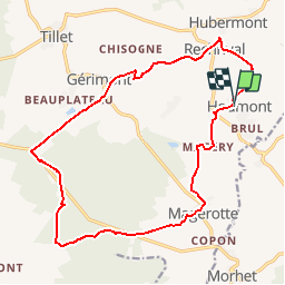
15,2 km | 18,6 km-effort
4h 13min
Ja
Tocht Stappen Sainte-Ode - Wandeling van Tonny - Photo
Stappen
GUIDE+

Stappen

Medium
(3)
Sainte-Ode, Wallonië, Luxemburg, Belgium
9,5 km | 12,2 km-effort
2h 36min
Ja
Tocht Stappen Sainte-Ode - Beauplateau - Wandeling
Stappen
GUIDE+

Stappen

Medium
(2)
Sainte-Ode, Wallonië, Luxemburg, Belgium
5,5 km | 6,9 km-effort
1h 29min
Ja
Tocht Stappen Sainte-Ode - Amberloup, Natura 2000 - Des sites qui valent le détour. Lx11 - Photo
Stappen
GUIDE+

Stappen

Gemakkelijk
(4)
Sainte-Ode, Wallonië, Luxemburg, Belgium
4,2 km | 5 km-effort
1h 6min
Ja
Tocht Stappen Sainte-Ode - RB-LUX-08 - De part et d’autre de l’Ourthe occidentale - Photo
Stappen
PRO

Stappen

Medium
(1)
Sainte-Ode, Wallonië, Luxemburg, Belgium
23 km | 29 km-effort
6h 14min
Ja
Tocht Stappen Sainte-Ode - Beauplateau - Le sentier du Coprin (GTA 4) - Photo
Stappen
GUIDE+

Stappen

Zeer moeilijk
(2)
Sainte-Ode, Wallonië, Luxemburg, Belgium
16,6 km | 20 km-effort
4h 20min
Ja
Tocht Stappen Sainte-Ode - Sainte-Ode  Wandeling van de hagen van Magery - Photo
Stappen
GUIDE+

Stappen

Medium
(3)
Sainte-Ode, Wallonië, Luxemburg, Belgium
9,3 km | 11,4 km-effort
2h 29min
Ja
Tocht Stappen Sainte-Ode - Sainte-Ode - Wandeling van de hagen van Valets - Photo
Stappen
GUIDE+

Stappen

Medium
(1)
Sainte-Ode, Wallonië, Luxemburg, Belgium
8,5 km | 10,1 km-effort
2h 12min
Ja
Tocht Te voet Vaux-sur-Sûre - Promenade des Vanneaux - Photo
Te voet
PRO

Te voet

Gemakkelijk
Vaux-sur-Sûre, Wallonië, Luxemburg, Belgium
11,5 km | 14,1 km-effort
3h 12min
Ja


Sluiten
Mijn abonnementen