Tocht Stappen Perche en Nocé - Préaux-du-Perche Sud - Photo

Préaux-du-Perche Sud

 guydu41
guydu41

Gebruiker

© OpenStreetMap contributors
Lengte
Lengte
7,9 km
Max. hoogte
Max. hoogte
199 m
Positief hoogteverschil
121 m
Km-Effort
Km-Effort  
9,5 km
Min. hoogte
Min. hoogte
116 m
Negatief hoogteverschil
122 m
Boucle
Boucle
Ja
Datum van aanmaak :
2023-06-21 06:46:14.526
Laatste wijziging :
2023-06-21 15:10:11.469

(0 Bericht)

Stappen
Stappen
2h09
Moeilijkheid : Medium

Scan deze QR-code om de tocht te openen in de SityTrail-applicatie

Gratisgps-wandelapplicatie

Logo SityTrail SityTrail

IGN / Geografische instituten

SityTrail uit de App Store downloaden SityTrail uit Google Play downloaden

Logo SityTrail SityTrail World

De wereld gaat voor u open

SityTrail uit de App Store downloaden SityTrail uit Google Play downloaden SityTrail op Huawei AppGallery downloaden

Over ons

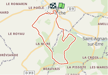
Tocht Stappen van 7,9 km beschikbaar op Normandië, Orne, Perche en Nocé. Deze tocht wordt voorgesteld door guydu41.

Beschrijving

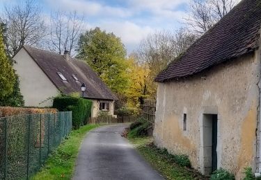
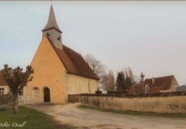
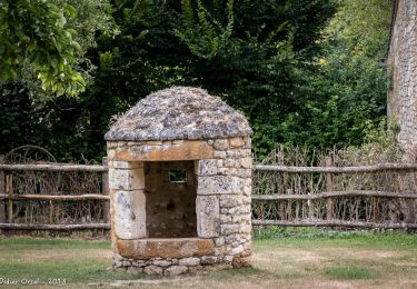
Petit circuit au Sud de Préaux-du-Perche à la découverte de son très beau parc avec un plan d'eau, deux lavoirs, des chemins herbeux.
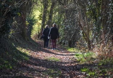
Le circuit emprunte de longs chemins bordés d'arbres, à travers champs, en bordure de vallées avec de belles vues.

Hoogteprofiel

Foto's

Plaatsbepaling

Land:
France
Regio :
Normandië
Departement/Provincie :
Orne
Gemeente :
Perche en Nocé
Locatie:
Unknown
Vertrek:(UTM)
329802 ; 5355464 (31U) N.

Wandeltochten in de omgeving

Tocht Stappen Perche en Nocé - Préaux-du-Perche Nord - Photo
Stappen
guydu41

Stappen

Gemakkelijk
(1)
Perche en Nocé, Normandië, Orne, France
11,3 km | 13,2 km-effort
2h 59min
Ja
Tocht Stappen Berd'huis - SityTrail - Berd'huis - Condé-sur-Huisne 14 km - Photo
Stappen
ODDAD78

Stappen

Moeilijk
Berd'huis, Normandië, Orne, France
13,9 km | 16,7 km-effort
3h 37min
Neen
Tocht Stappen Berd'huis - SityTrail - Berd'huis - Saint-Cyr-la-Rosière via Préaux-du-Perche 12 km - Photo
Stappen

Stappen

Heel gemakkelijk
Berd'huis, Normandië, Orne, France
4,1 km | 4,9 km-effort
1h 0min
Neen
Tocht Stappen Perche en Nocé - SityTrail - St Aubin des Grois 13.66 - Photo
Stappen
ODDAD78

Stappen

Medium
Perche en Nocé, Normandië, Orne, France
13,6 km | 16,2 km-effort
3h 33min
Ja
Tocht Stappen Saint-Cyr-la-Rosière - Au fil de la Rosière 7,1 Km - Photo
Stappen
ODDAD78

Stappen

Medium
Saint-Cyr-la-Rosière, Normandië, Orne, France
7,1 km | 8,6 km-effort
1h 57min
Ja
Tocht Stappen Perche en Nocé - Nocé-Courboyer - Saint-Aubin-des-Grois 9,5 km - Photo
Stappen

Stappen

Gemakkelijk
Perche en Nocé, Normandië, Orne, France
9,5 km | 11,2 km-effort
2h 25min
Neen
Tocht Stappen Perche en Nocé - Val d'Enfer 17Km - Photo
Stappen
ODDAD78

Stappen

Medium
Perche en Nocé, Normandië, Orne, France
16,7 km | 19,5 km-effort
4h 16min
Ja
Tocht Stappen Perche en Nocé - Nobles logis (Préaux-du-Perche) 9,4Km - Photo
Stappen
ODDAD78

Stappen

Gemakkelijk
Perche en Nocé, Normandië, Orne, France
9,3 km | 10,9 km-effort
2h 19min
Ja
Tocht Stappen Perche en Nocé - Les Panoramas 5,5 Km - Photo
Stappen
ODDAD78

Stappen

Heel gemakkelijk
Perche en Nocé, Normandië, Orne, France
5,4 km | 6,5 km-effort
1h 15min
Ja


Sluiten
Mijn abonnementen