


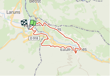

6 km | 9,9 km-effort


Gebruiker GUIDE


Gratisgps-wandelapplicatie
 SityTrail
IGN / Geografische instituten
SityTrail World
De wereld gaat voor u open
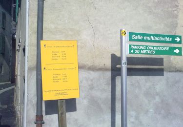
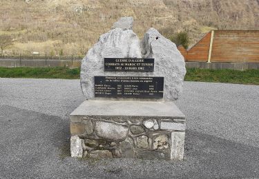
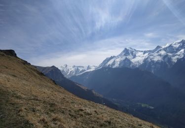
Tocht Stappen van 8,2 km beschikbaar op Nieuw-Aquitanië, Pyrénées-Atlantiques, Laruns. Deze tocht wordt voorgesteld door marmotte65.
Superbe promenade dans des endroits méconnus de Laruns.
 "
data-pinterest-text="Pin it"
data-tweet-text="share on twitter"
data-facebook-share-url="https://www.sitytrail.com/nl/trails/3717878-laruns--laruns-le-tour-du-valentin-g3-x3717878x/?photo=1#lg=1&slide=1"
data-twitter-share-url="https://www.sitytrail.com/nl/trails/3717878-laruns--laruns-le-tour-du-valentin-g3-x3717878x/?photo=1#lg=1&slide=1"
data-googleplus-share-url="https://www.sitytrail.com/nl/trails/3717878-laruns--laruns-le-tour-du-valentin-g3-x3717878x/?photo=1#lg=1&slide=1"
data-pinterest-share-url="https://www.sitytrail.com/nl/trails/3717878-laruns--laruns-le-tour-du-valentin-g3-x3717878x/?photo=1#lg=1&slide=1">
"
data-pinterest-text="Pin it"
data-tweet-text="share on twitter"
data-facebook-share-url="https://www.sitytrail.com/nl/trails/3717878-laruns--laruns-le-tour-du-valentin-g3-x3717878x/?photo=1#lg=1&slide=1"
data-twitter-share-url="https://www.sitytrail.com/nl/trails/3717878-laruns--laruns-le-tour-du-valentin-g3-x3717878x/?photo=1#lg=1&slide=1"
data-googleplus-share-url="https://www.sitytrail.com/nl/trails/3717878-laruns--laruns-le-tour-du-valentin-g3-x3717878x/?photo=1#lg=1&slide=1"
data-pinterest-share-url="https://www.sitytrail.com/nl/trails/3717878-laruns--laruns-le-tour-du-valentin-g3-x3717878x/?photo=1#lg=1&slide=1">
 "
data-pinterest-text="Pin it"
data-tweet-text="share on twitter"
data-facebook-share-url="https://www.sitytrail.com/nl/trails/3717878-laruns--laruns-le-tour-du-valentin-g3-x3717878x/?photo=2#lg=1&slide=2"
data-twitter-share-url="https://www.sitytrail.com/nl/trails/3717878-laruns--laruns-le-tour-du-valentin-g3-x3717878x/?photo=2#lg=1&slide=2"
data-googleplus-share-url="https://www.sitytrail.com/nl/trails/3717878-laruns--laruns-le-tour-du-valentin-g3-x3717878x/?photo=2#lg=1&slide=2"
data-pinterest-share-url="https://www.sitytrail.com/nl/trails/3717878-laruns--laruns-le-tour-du-valentin-g3-x3717878x/?photo=2#lg=1&slide=2">
"
data-pinterest-text="Pin it"
data-tweet-text="share on twitter"
data-facebook-share-url="https://www.sitytrail.com/nl/trails/3717878-laruns--laruns-le-tour-du-valentin-g3-x3717878x/?photo=2#lg=1&slide=2"
data-twitter-share-url="https://www.sitytrail.com/nl/trails/3717878-laruns--laruns-le-tour-du-valentin-g3-x3717878x/?photo=2#lg=1&slide=2"
data-googleplus-share-url="https://www.sitytrail.com/nl/trails/3717878-laruns--laruns-le-tour-du-valentin-g3-x3717878x/?photo=2#lg=1&slide=2"
data-pinterest-share-url="https://www.sitytrail.com/nl/trails/3717878-laruns--laruns-le-tour-du-valentin-g3-x3717878x/?photo=2#lg=1&slide=2">
 "
data-pinterest-text="Pin it"
data-tweet-text="share on twitter"
data-facebook-share-url="https://www.sitytrail.com/nl/trails/3717878-laruns--laruns-le-tour-du-valentin-g3-x3717878x/?photo=3#lg=1&slide=3"
data-twitter-share-url="https://www.sitytrail.com/nl/trails/3717878-laruns--laruns-le-tour-du-valentin-g3-x3717878x/?photo=3#lg=1&slide=3"
data-googleplus-share-url="https://www.sitytrail.com/nl/trails/3717878-laruns--laruns-le-tour-du-valentin-g3-x3717878x/?photo=3#lg=1&slide=3"
data-pinterest-share-url="https://www.sitytrail.com/nl/trails/3717878-laruns--laruns-le-tour-du-valentin-g3-x3717878x/?photo=3#lg=1&slide=3">
"
data-pinterest-text="Pin it"
data-tweet-text="share on twitter"
data-facebook-share-url="https://www.sitytrail.com/nl/trails/3717878-laruns--laruns-le-tour-du-valentin-g3-x3717878x/?photo=3#lg=1&slide=3"
data-twitter-share-url="https://www.sitytrail.com/nl/trails/3717878-laruns--laruns-le-tour-du-valentin-g3-x3717878x/?photo=3#lg=1&slide=3"
data-googleplus-share-url="https://www.sitytrail.com/nl/trails/3717878-laruns--laruns-le-tour-du-valentin-g3-x3717878x/?photo=3#lg=1&slide=3"
data-pinterest-share-url="https://www.sitytrail.com/nl/trails/3717878-laruns--laruns-le-tour-du-valentin-g3-x3717878x/?photo=3#lg=1&slide=3">
 "
data-pinterest-text="Pin it"
data-tweet-text="share on twitter"
data-facebook-share-url="https://www.sitytrail.com/nl/trails/3717878-laruns--laruns-le-tour-du-valentin-g3-x3717878x/?photo=4#lg=1&slide=4"
data-twitter-share-url="https://www.sitytrail.com/nl/trails/3717878-laruns--laruns-le-tour-du-valentin-g3-x3717878x/?photo=4#lg=1&slide=4"
data-googleplus-share-url="https://www.sitytrail.com/nl/trails/3717878-laruns--laruns-le-tour-du-valentin-g3-x3717878x/?photo=4#lg=1&slide=4"
data-pinterest-share-url="https://www.sitytrail.com/nl/trails/3717878-laruns--laruns-le-tour-du-valentin-g3-x3717878x/?photo=4#lg=1&slide=4">
"
data-pinterest-text="Pin it"
data-tweet-text="share on twitter"
data-facebook-share-url="https://www.sitytrail.com/nl/trails/3717878-laruns--laruns-le-tour-du-valentin-g3-x3717878x/?photo=4#lg=1&slide=4"
data-twitter-share-url="https://www.sitytrail.com/nl/trails/3717878-laruns--laruns-le-tour-du-valentin-g3-x3717878x/?photo=4#lg=1&slide=4"
data-googleplus-share-url="https://www.sitytrail.com/nl/trails/3717878-laruns--laruns-le-tour-du-valentin-g3-x3717878x/?photo=4#lg=1&slide=4"
data-pinterest-share-url="https://www.sitytrail.com/nl/trails/3717878-laruns--laruns-le-tour-du-valentin-g3-x3717878x/?photo=4#lg=1&slide=4">
 "
data-pinterest-text="Pin it"
data-tweet-text="share on twitter"
data-facebook-share-url="https://www.sitytrail.com/nl/trails/3717878-laruns--laruns-le-tour-du-valentin-g3-x3717878x/?photo=5#lg=1&slide=5"
data-twitter-share-url="https://www.sitytrail.com/nl/trails/3717878-laruns--laruns-le-tour-du-valentin-g3-x3717878x/?photo=5#lg=1&slide=5"
data-googleplus-share-url="https://www.sitytrail.com/nl/trails/3717878-laruns--laruns-le-tour-du-valentin-g3-x3717878x/?photo=5#lg=1&slide=5"
data-pinterest-share-url="https://www.sitytrail.com/nl/trails/3717878-laruns--laruns-le-tour-du-valentin-g3-x3717878x/?photo=5#lg=1&slide=5">
"
data-pinterest-text="Pin it"
data-tweet-text="share on twitter"
data-facebook-share-url="https://www.sitytrail.com/nl/trails/3717878-laruns--laruns-le-tour-du-valentin-g3-x3717878x/?photo=5#lg=1&slide=5"
data-twitter-share-url="https://www.sitytrail.com/nl/trails/3717878-laruns--laruns-le-tour-du-valentin-g3-x3717878x/?photo=5#lg=1&slide=5"
data-googleplus-share-url="https://www.sitytrail.com/nl/trails/3717878-laruns--laruns-le-tour-du-valentin-g3-x3717878x/?photo=5#lg=1&slide=5"
data-pinterest-share-url="https://www.sitytrail.com/nl/trails/3717878-laruns--laruns-le-tour-du-valentin-g3-x3717878x/?photo=5#lg=1&slide=5">
 "
data-pinterest-text="Pin it"
data-tweet-text="share on twitter"
data-facebook-share-url="https://www.sitytrail.com/nl/trails/3717878-laruns--laruns-le-tour-du-valentin-g3-x3717878x/?photo=6#lg=1&slide=6"
data-twitter-share-url="https://www.sitytrail.com/nl/trails/3717878-laruns--laruns-le-tour-du-valentin-g3-x3717878x/?photo=6#lg=1&slide=6"
data-googleplus-share-url="https://www.sitytrail.com/nl/trails/3717878-laruns--laruns-le-tour-du-valentin-g3-x3717878x/?photo=6#lg=1&slide=6"
data-pinterest-share-url="https://www.sitytrail.com/nl/trails/3717878-laruns--laruns-le-tour-du-valentin-g3-x3717878x/?photo=6#lg=1&slide=6">
"
data-pinterest-text="Pin it"
data-tweet-text="share on twitter"
data-facebook-share-url="https://www.sitytrail.com/nl/trails/3717878-laruns--laruns-le-tour-du-valentin-g3-x3717878x/?photo=6#lg=1&slide=6"
data-twitter-share-url="https://www.sitytrail.com/nl/trails/3717878-laruns--laruns-le-tour-du-valentin-g3-x3717878x/?photo=6#lg=1&slide=6"
data-googleplus-share-url="https://www.sitytrail.com/nl/trails/3717878-laruns--laruns-le-tour-du-valentin-g3-x3717878x/?photo=6#lg=1&slide=6"
data-pinterest-share-url="https://www.sitytrail.com/nl/trails/3717878-laruns--laruns-le-tour-du-valentin-g3-x3717878x/?photo=6#lg=1&slide=6">
 "
data-pinterest-text="Pin it"
data-tweet-text="share on twitter"
data-facebook-share-url="https://www.sitytrail.com/nl/trails/3717878-laruns--laruns-le-tour-du-valentin-g3-x3717878x/?photo=7#lg=1&slide=7"
data-twitter-share-url="https://www.sitytrail.com/nl/trails/3717878-laruns--laruns-le-tour-du-valentin-g3-x3717878x/?photo=7#lg=1&slide=7"
data-googleplus-share-url="https://www.sitytrail.com/nl/trails/3717878-laruns--laruns-le-tour-du-valentin-g3-x3717878x/?photo=7#lg=1&slide=7"
data-pinterest-share-url="https://www.sitytrail.com/nl/trails/3717878-laruns--laruns-le-tour-du-valentin-g3-x3717878x/?photo=7#lg=1&slide=7">
"
data-pinterest-text="Pin it"
data-tweet-text="share on twitter"
data-facebook-share-url="https://www.sitytrail.com/nl/trails/3717878-laruns--laruns-le-tour-du-valentin-g3-x3717878x/?photo=7#lg=1&slide=7"
data-twitter-share-url="https://www.sitytrail.com/nl/trails/3717878-laruns--laruns-le-tour-du-valentin-g3-x3717878x/?photo=7#lg=1&slide=7"
data-googleplus-share-url="https://www.sitytrail.com/nl/trails/3717878-laruns--laruns-le-tour-du-valentin-g3-x3717878x/?photo=7#lg=1&slide=7"
data-pinterest-share-url="https://www.sitytrail.com/nl/trails/3717878-laruns--laruns-le-tour-du-valentin-g3-x3717878x/?photo=7#lg=1&slide=7">
 "
data-pinterest-text="Pin it"
data-tweet-text="share on twitter"
data-facebook-share-url="https://www.sitytrail.com/nl/trails/3717878-laruns--laruns-le-tour-du-valentin-g3-x3717878x/?photo=8#lg=1&slide=8"
data-twitter-share-url="https://www.sitytrail.com/nl/trails/3717878-laruns--laruns-le-tour-du-valentin-g3-x3717878x/?photo=8#lg=1&slide=8"
data-googleplus-share-url="https://www.sitytrail.com/nl/trails/3717878-laruns--laruns-le-tour-du-valentin-g3-x3717878x/?photo=8#lg=1&slide=8"
data-pinterest-share-url="https://www.sitytrail.com/nl/trails/3717878-laruns--laruns-le-tour-du-valentin-g3-x3717878x/?photo=8#lg=1&slide=8">
"
data-pinterest-text="Pin it"
data-tweet-text="share on twitter"
data-facebook-share-url="https://www.sitytrail.com/nl/trails/3717878-laruns--laruns-le-tour-du-valentin-g3-x3717878x/?photo=8#lg=1&slide=8"
data-twitter-share-url="https://www.sitytrail.com/nl/trails/3717878-laruns--laruns-le-tour-du-valentin-g3-x3717878x/?photo=8#lg=1&slide=8"
data-googleplus-share-url="https://www.sitytrail.com/nl/trails/3717878-laruns--laruns-le-tour-du-valentin-g3-x3717878x/?photo=8#lg=1&slide=8"
data-pinterest-share-url="https://www.sitytrail.com/nl/trails/3717878-laruns--laruns-le-tour-du-valentin-g3-x3717878x/?photo=8#lg=1&slide=8">
 "
data-pinterest-text="Pin it"
data-tweet-text="share on twitter"
data-facebook-share-url="https://www.sitytrail.com/nl/trails/3717878-laruns--laruns-le-tour-du-valentin-g3-x3717878x/?photo=9#lg=1&slide=9"
data-twitter-share-url="https://www.sitytrail.com/nl/trails/3717878-laruns--laruns-le-tour-du-valentin-g3-x3717878x/?photo=9#lg=1&slide=9"
data-googleplus-share-url="https://www.sitytrail.com/nl/trails/3717878-laruns--laruns-le-tour-du-valentin-g3-x3717878x/?photo=9#lg=1&slide=9"
data-pinterest-share-url="https://www.sitytrail.com/nl/trails/3717878-laruns--laruns-le-tour-du-valentin-g3-x3717878x/?photo=9#lg=1&slide=9">
"
data-pinterest-text="Pin it"
data-tweet-text="share on twitter"
data-facebook-share-url="https://www.sitytrail.com/nl/trails/3717878-laruns--laruns-le-tour-du-valentin-g3-x3717878x/?photo=9#lg=1&slide=9"
data-twitter-share-url="https://www.sitytrail.com/nl/trails/3717878-laruns--laruns-le-tour-du-valentin-g3-x3717878x/?photo=9#lg=1&slide=9"
data-googleplus-share-url="https://www.sitytrail.com/nl/trails/3717878-laruns--laruns-le-tour-du-valentin-g3-x3717878x/?photo=9#lg=1&slide=9"
data-pinterest-share-url="https://www.sitytrail.com/nl/trails/3717878-laruns--laruns-le-tour-du-valentin-g3-x3717878x/?photo=9#lg=1&slide=9">
 "
data-pinterest-text="Pin it"
data-tweet-text="share on twitter"
data-facebook-share-url="https://www.sitytrail.com/nl/trails/3717878-laruns--laruns-le-tour-du-valentin-g3-x3717878x/?photo=10#lg=1&slide=10"
data-twitter-share-url="https://www.sitytrail.com/nl/trails/3717878-laruns--laruns-le-tour-du-valentin-g3-x3717878x/?photo=10#lg=1&slide=10"
data-googleplus-share-url="https://www.sitytrail.com/nl/trails/3717878-laruns--laruns-le-tour-du-valentin-g3-x3717878x/?photo=10#lg=1&slide=10"
data-pinterest-share-url="https://www.sitytrail.com/nl/trails/3717878-laruns--laruns-le-tour-du-valentin-g3-x3717878x/?photo=10#lg=1&slide=10">
"
data-pinterest-text="Pin it"
data-tweet-text="share on twitter"
data-facebook-share-url="https://www.sitytrail.com/nl/trails/3717878-laruns--laruns-le-tour-du-valentin-g3-x3717878x/?photo=10#lg=1&slide=10"
data-twitter-share-url="https://www.sitytrail.com/nl/trails/3717878-laruns--laruns-le-tour-du-valentin-g3-x3717878x/?photo=10#lg=1&slide=10"
data-googleplus-share-url="https://www.sitytrail.com/nl/trails/3717878-laruns--laruns-le-tour-du-valentin-g3-x3717878x/?photo=10#lg=1&slide=10"
data-pinterest-share-url="https://www.sitytrail.com/nl/trails/3717878-laruns--laruns-le-tour-du-valentin-g3-x3717878x/?photo=10#lg=1&slide=10">
 "
data-pinterest-text="Pin it"
data-tweet-text="share on twitter"
data-facebook-share-url="https://www.sitytrail.com/nl/trails/3717878-laruns--laruns-le-tour-du-valentin-g3-x3717878x/?photo=11#lg=1&slide=11"
data-twitter-share-url="https://www.sitytrail.com/nl/trails/3717878-laruns--laruns-le-tour-du-valentin-g3-x3717878x/?photo=11#lg=1&slide=11"
data-googleplus-share-url="https://www.sitytrail.com/nl/trails/3717878-laruns--laruns-le-tour-du-valentin-g3-x3717878x/?photo=11#lg=1&slide=11"
data-pinterest-share-url="https://www.sitytrail.com/nl/trails/3717878-laruns--laruns-le-tour-du-valentin-g3-x3717878x/?photo=11#lg=1&slide=11">
"
data-pinterest-text="Pin it"
data-tweet-text="share on twitter"
data-facebook-share-url="https://www.sitytrail.com/nl/trails/3717878-laruns--laruns-le-tour-du-valentin-g3-x3717878x/?photo=11#lg=1&slide=11"
data-twitter-share-url="https://www.sitytrail.com/nl/trails/3717878-laruns--laruns-le-tour-du-valentin-g3-x3717878x/?photo=11#lg=1&slide=11"
data-googleplus-share-url="https://www.sitytrail.com/nl/trails/3717878-laruns--laruns-le-tour-du-valentin-g3-x3717878x/?photo=11#lg=1&slide=11"
data-pinterest-share-url="https://www.sitytrail.com/nl/trails/3717878-laruns--laruns-le-tour-du-valentin-g3-x3717878x/?photo=11#lg=1&slide=11">
 "
data-pinterest-text="Pin it"
data-tweet-text="share on twitter"
data-facebook-share-url="https://www.sitytrail.com/nl/trails/3717878-laruns--laruns-le-tour-du-valentin-g3-x3717878x/?photo=12#lg=1&slide=12"
data-twitter-share-url="https://www.sitytrail.com/nl/trails/3717878-laruns--laruns-le-tour-du-valentin-g3-x3717878x/?photo=12#lg=1&slide=12"
data-googleplus-share-url="https://www.sitytrail.com/nl/trails/3717878-laruns--laruns-le-tour-du-valentin-g3-x3717878x/?photo=12#lg=1&slide=12"
data-pinterest-share-url="https://www.sitytrail.com/nl/trails/3717878-laruns--laruns-le-tour-du-valentin-g3-x3717878x/?photo=12#lg=1&slide=12">
"
data-pinterest-text="Pin it"
data-tweet-text="share on twitter"
data-facebook-share-url="https://www.sitytrail.com/nl/trails/3717878-laruns--laruns-le-tour-du-valentin-g3-x3717878x/?photo=12#lg=1&slide=12"
data-twitter-share-url="https://www.sitytrail.com/nl/trails/3717878-laruns--laruns-le-tour-du-valentin-g3-x3717878x/?photo=12#lg=1&slide=12"
data-googleplus-share-url="https://www.sitytrail.com/nl/trails/3717878-laruns--laruns-le-tour-du-valentin-g3-x3717878x/?photo=12#lg=1&slide=12"
data-pinterest-share-url="https://www.sitytrail.com/nl/trails/3717878-laruns--laruns-le-tour-du-valentin-g3-x3717878x/?photo=12#lg=1&slide=12">
 "
data-pinterest-text="Pin it"
data-tweet-text="share on twitter"
data-facebook-share-url="https://www.sitytrail.com/nl/trails/3717878-laruns--laruns-le-tour-du-valentin-g3-x3717878x/?photo=13#lg=1&slide=13"
data-twitter-share-url="https://www.sitytrail.com/nl/trails/3717878-laruns--laruns-le-tour-du-valentin-g3-x3717878x/?photo=13#lg=1&slide=13"
data-googleplus-share-url="https://www.sitytrail.com/nl/trails/3717878-laruns--laruns-le-tour-du-valentin-g3-x3717878x/?photo=13#lg=1&slide=13"
data-pinterest-share-url="https://www.sitytrail.com/nl/trails/3717878-laruns--laruns-le-tour-du-valentin-g3-x3717878x/?photo=13#lg=1&slide=13">
"
data-pinterest-text="Pin it"
data-tweet-text="share on twitter"
data-facebook-share-url="https://www.sitytrail.com/nl/trails/3717878-laruns--laruns-le-tour-du-valentin-g3-x3717878x/?photo=13#lg=1&slide=13"
data-twitter-share-url="https://www.sitytrail.com/nl/trails/3717878-laruns--laruns-le-tour-du-valentin-g3-x3717878x/?photo=13#lg=1&slide=13"
data-googleplus-share-url="https://www.sitytrail.com/nl/trails/3717878-laruns--laruns-le-tour-du-valentin-g3-x3717878x/?photo=13#lg=1&slide=13"
data-pinterest-share-url="https://www.sitytrail.com/nl/trails/3717878-laruns--laruns-le-tour-du-valentin-g3-x3717878x/?photo=13#lg=1&slide=13">
 "
data-pinterest-text="Pin it"
data-tweet-text="share on twitter"
data-facebook-share-url="https://www.sitytrail.com/nl/trails/3717878-laruns--laruns-le-tour-du-valentin-g3-x3717878x/?photo=14#lg=1&slide=14"
data-twitter-share-url="https://www.sitytrail.com/nl/trails/3717878-laruns--laruns-le-tour-du-valentin-g3-x3717878x/?photo=14#lg=1&slide=14"
data-googleplus-share-url="https://www.sitytrail.com/nl/trails/3717878-laruns--laruns-le-tour-du-valentin-g3-x3717878x/?photo=14#lg=1&slide=14"
data-pinterest-share-url="https://www.sitytrail.com/nl/trails/3717878-laruns--laruns-le-tour-du-valentin-g3-x3717878x/?photo=14#lg=1&slide=14">
"
data-pinterest-text="Pin it"
data-tweet-text="share on twitter"
data-facebook-share-url="https://www.sitytrail.com/nl/trails/3717878-laruns--laruns-le-tour-du-valentin-g3-x3717878x/?photo=14#lg=1&slide=14"
data-twitter-share-url="https://www.sitytrail.com/nl/trails/3717878-laruns--laruns-le-tour-du-valentin-g3-x3717878x/?photo=14#lg=1&slide=14"
data-googleplus-share-url="https://www.sitytrail.com/nl/trails/3717878-laruns--laruns-le-tour-du-valentin-g3-x3717878x/?photo=14#lg=1&slide=14"
data-pinterest-share-url="https://www.sitytrail.com/nl/trails/3717878-laruns--laruns-le-tour-du-valentin-g3-x3717878x/?photo=14#lg=1&slide=14">
 "
data-pinterest-text="Pin it"
data-tweet-text="share on twitter"
data-facebook-share-url="https://www.sitytrail.com/nl/trails/3717878-laruns--laruns-le-tour-du-valentin-g3-x3717878x/?photo=15#lg=1&slide=15"
data-twitter-share-url="https://www.sitytrail.com/nl/trails/3717878-laruns--laruns-le-tour-du-valentin-g3-x3717878x/?photo=15#lg=1&slide=15"
data-googleplus-share-url="https://www.sitytrail.com/nl/trails/3717878-laruns--laruns-le-tour-du-valentin-g3-x3717878x/?photo=15#lg=1&slide=15"
data-pinterest-share-url="https://www.sitytrail.com/nl/trails/3717878-laruns--laruns-le-tour-du-valentin-g3-x3717878x/?photo=15#lg=1&slide=15">
"
data-pinterest-text="Pin it"
data-tweet-text="share on twitter"
data-facebook-share-url="https://www.sitytrail.com/nl/trails/3717878-laruns--laruns-le-tour-du-valentin-g3-x3717878x/?photo=15#lg=1&slide=15"
data-twitter-share-url="https://www.sitytrail.com/nl/trails/3717878-laruns--laruns-le-tour-du-valentin-g3-x3717878x/?photo=15#lg=1&slide=15"
data-googleplus-share-url="https://www.sitytrail.com/nl/trails/3717878-laruns--laruns-le-tour-du-valentin-g3-x3717878x/?photo=15#lg=1&slide=15"
data-pinterest-share-url="https://www.sitytrail.com/nl/trails/3717878-laruns--laruns-le-tour-du-valentin-g3-x3717878x/?photo=15#lg=1&slide=15">
 "
data-pinterest-text="Pin it"
data-tweet-text="share on twitter"
data-facebook-share-url="https://www.sitytrail.com/nl/trails/3717878-laruns--laruns-le-tour-du-valentin-g3-x3717878x/?photo=16#lg=1&slide=16"
data-twitter-share-url="https://www.sitytrail.com/nl/trails/3717878-laruns--laruns-le-tour-du-valentin-g3-x3717878x/?photo=16#lg=1&slide=16"
data-googleplus-share-url="https://www.sitytrail.com/nl/trails/3717878-laruns--laruns-le-tour-du-valentin-g3-x3717878x/?photo=16#lg=1&slide=16"
data-pinterest-share-url="https://www.sitytrail.com/nl/trails/3717878-laruns--laruns-le-tour-du-valentin-g3-x3717878x/?photo=16#lg=1&slide=16">
"
data-pinterest-text="Pin it"
data-tweet-text="share on twitter"
data-facebook-share-url="https://www.sitytrail.com/nl/trails/3717878-laruns--laruns-le-tour-du-valentin-g3-x3717878x/?photo=16#lg=1&slide=16"
data-twitter-share-url="https://www.sitytrail.com/nl/trails/3717878-laruns--laruns-le-tour-du-valentin-g3-x3717878x/?photo=16#lg=1&slide=16"
data-googleplus-share-url="https://www.sitytrail.com/nl/trails/3717878-laruns--laruns-le-tour-du-valentin-g3-x3717878x/?photo=16#lg=1&slide=16"
data-pinterest-share-url="https://www.sitytrail.com/nl/trails/3717878-laruns--laruns-le-tour-du-valentin-g3-x3717878x/?photo=16#lg=1&slide=16">


Stappen

Te voet
Te voet
Te voet
Te voet
Te voet
Te voet
Te voet
Stappen