Tocht Fiets Apt - Parcours n°7 - Apt - Photo

Randonnées de Vélo Loisir Provence GUIDE+

© OpenStreetMap contributors
Lengte
Lengte
47 km
Max. hoogte
Max. hoogte
579 m
Positief hoogteverschil
793 m
Km-Effort
Km-Effort  
58 km
Min. hoogte
Min. hoogte
219 m
Negatief hoogteverschil
791 m
Boucle
Boucle
Ja
Datum van aanmaak :
2015-01-07 00:00:00.0
Laatste wijziging :
2015-01-07 00:00:00.0

(0 Bericht)

Fiets
Fiets
3h17
Moeilijkheid : Moeilijk

Scan deze QR-code om de tocht te openen in de SityTrail-applicatie

Gratisgps-wandelapplicatie

Logo SityTrail SityTrail

IGN / Geografische instituten

SityTrail uit de App Store downloaden SityTrail uit Google Play downloaden

Logo SityTrail SityTrail World

De wereld gaat voor u open

SityTrail uit de App Store downloaden SityTrail uit Google Play downloaden SityTrail op Huawei AppGallery downloaden

Over ons

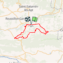
Tocht Fiets van 47 km beschikbaar op Provence-Alpes-Côte d'Azur, Vaucluse, Apt. Deze tocht wordt voorgesteld door Vélo Loisir Provence.

Beschrijving

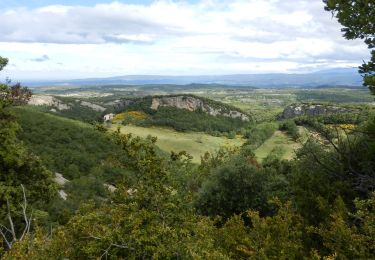
A ride among villages situated between the two massifs of the Luberon. Direction of the itinerary : Apt => Bonnieux => Buoux => Saignon => Castellet => Apt

Hoogteprofiel

Foto's

Plaatsbepaling

Land:
France
Regio :
Provence-Alpes-Côte d'Azur
Departement/Provincie :
Vaucluse
Gemeente :
Apt
Locatie:
Unknown
Vertrek:(Dec)
Vertrek:(UTM)
692783 ; 4861061 (31T) N.

Wandeltochten in de omgeving

Tocht Fiets Apt - Les Ocres à vélo - Photo
Fiets
GUIDE+

Fiets

Medium
(4)
Apt, Provence-Alpes-Côte d'Azur, Vaucluse, France
51 km | 61 km-effort
3h 31min
Ja
Tocht Stappen Saignon - Saignon  Bories - Photo
Stappen
kephas

Stappen

Gemakkelijk
(2)
Saignon, Provence-Alpes-Côte d'Azur, Vaucluse, France
10,8 km | 13,8 km-effort
3h 2min
Ja
Tocht Stappen Buoux - Plateau des Claparèdes - Saignon - Photo
Stappen
tracegps

Stappen

Medium
(1)
Buoux, Provence-Alpes-Côte d'Azur, Vaucluse, France
10,8 km | 14,6 km-effort
5h 0min
Ja
Tocht Fiets Apt - Circuit Vélo - Les Ocres en vélo - Apt - Photo
Fiets
tracegps

Fiets

Moeilijk
(1)
Apt, Provence-Alpes-Côte d'Azur, Vaucluse, France
50 km | 60 km-effort
5h 0min
Ja
Tocht Stappen Auribeau - Le Mourre Nègre - Photo
Stappen
makounet

Stappen

Medium
(1)
Auribeau, Provence-Alpes-Côte d'Azur, Vaucluse, France
16,1 km | 27 km-effort
5h 31min
Ja
Tocht Stappen Buoux - Buoux /Saignon - Photo
Stappen
FLORENSAC

Stappen

Moeilijk
Buoux, Provence-Alpes-Côte d'Azur, Vaucluse, France
12,4 km | 15,6 km-effort
5h 45min
Ja
Tocht Stappen Auribeau - Auribeau Mourre Négre retour Auribeau - Photo
Stappen
jll7513

Stappen

Medium
Auribeau, Provence-Alpes-Côte d'Azur, Vaucluse, France
8,5 km | 16,1 km-effort
3h 38min
Ja
Tocht Stappen Apt - CR_Domitia_BE_25_Apt_Cereste_20220407 - Photo
Stappen
patrickdanilo

Stappen

Medium
Apt, Provence-Alpes-Côte d'Azur, Vaucluse, France
21 km | 29 km-effort
5h 54min
Neen
Tocht Stappen Buoux - SityTrail - 2428982 - grp-luberon-tour-des-clapaedes-42km - Photo
Stappen
GUIDE
thonyc

Stappen

Moeilijk
Buoux, Provence-Alpes-Côte d'Azur, Vaucluse, France
17,7 km | 23 km-effort
5h 40min
Ja


Sluiten
Mijn abonnementen