Tocht Stappen Xertigny - Cirkwi-Le_Tabourin - Photo

Cirkwi-Le_Tabourin

 Emmanuel Remy
Emmanuel Remy

Gebruiker

© OpenStreetMap contributors
Lengte
Lengte
4,6 km
Max. hoogte
Max. hoogte
418 m
Positief hoogteverschil
105 m
Km-Effort
Km-Effort  
6 km
Min. hoogte
Min. hoogte
349 m
Negatief hoogteverschil
104 m
Boucle
Boucle
Ja
Datum van aanmaak :
2023-10-12 10:27:39.235
Laatste wijziging :
2023-10-12 10:36:17.752

(0 Bericht)

Stappen
Stappen
1h22
Moeilijkheid : Medium

Scan deze QR-code om de tocht te openen in de SityTrail-applicatie

Gratisgps-wandelapplicatie

Logo SityTrail SityTrail

IGN / Geografische instituten

SityTrail uit de App Store downloaden SityTrail uit Google Play downloaden

Logo SityTrail SityTrail World

De wereld gaat voor u open

SityTrail uit de App Store downloaden SityTrail uit Google Play downloaden SityTrail op Huawei AppGallery downloaden

Over ons

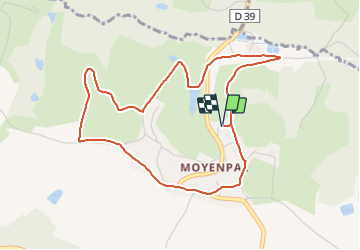
Tocht Stappen van 4,6 km beschikbaar op Grand Est, Vogezen, Xertigny. Deze tocht wordt voorgesteld door Emmanuel Remy.

Beschrijving

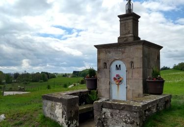
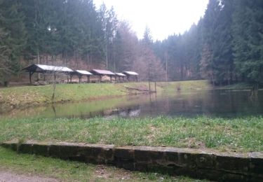
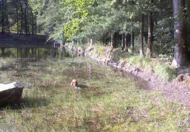
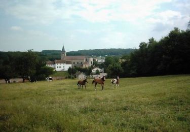
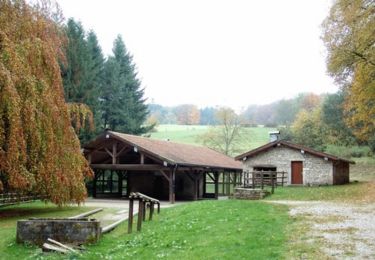
Ce parcours évolue autour du village de Moyenpal, un hameau de la commune de Xertigny. Il plonge le promeneur dans un paysage champêtre à travers différents pâturages. Il vient également affleurer la petite rivière du Cône qui prend sa source à dix kilomètres de là au lieu dit "le milieu du monde" sur la ligne de séparation des eaux entre les bassins de la Mer du Nord et de la Méditerranée. L’attention du promeneur sera stimulée successivement par de jolis points de vue sur la vallée et les forêts environnantes, une fontaine, une structure de ferme peu courante tout en rencontrant certains marqueurs de la société moderne.

Hoogteprofiel

POI's

POI Xertigny -  - Photo
Emmanuel Remy
XERTIGNY 
POI Xertigny -  - Photo
Emmanuel Remy
XERTIGNY 
POI Xertigny -  - Photo
Emmanuel Remy
XERTIGNY 
POI Xertigny -  - Photo
Emmanuel Remy
XERTIGNY 
POI Xertigny -  - Photo
Emmanuel Remy
XERTIGNY 
POI Xertigny -  - Photo
Emmanuel Remy
XERTIGNY 
POI Xertigny -  - Photo
Emmanuel Remy
XERTIGNY 
POI Xertigny -  - Photo
Emmanuel Remy
XERTIGNY 

Plaatsbepaling

Land:
France
Regio :
Grand Est
Departement/Provincie :
Vogezen
Gemeente :
Xertigny
Locatie:
Unknown
Vertrek:(Dec)
Vertrek:(UTM)
303843 ; 5326889 (32U) N.

Wandeltochten in de omgeving

Tocht Stappen Xertigny - l)Etapa 12 - Photo
Stappen
RafaTuareg

Stappen

Gemakkelijk
Xertigny, Grand Est, Vogezen, France
23 km | 30 km-effort
5h 2min
Neen
Tocht Mountainbike Uriménil - Espace VTT FFC Chemins du Pays d'Epinal, Coeur des Vosges - circuit n°99 - Chapuis Chantré - Photo
Mountainbike
tracegps

Mountainbike

Moeilijk
Uriménil, Grand Est, Vogezen, France
28 km | 36 km-effort
2h 15min
Ja
Tocht Stappen Xertigny - Xertigny : circuit n'5 les granges Richard 10-05-19 - Photo
Stappen
annefrance70

Stappen

Gemakkelijk
Xertigny, Grand Est, Vogezen, France
9,4 km | 12,3 km-effort
2h 0min
Ja
Tocht Stappen Xertigny - Les Bois Beaudoin - Photo
Stappen
jeanclaude12

Stappen

Gemakkelijk
Xertigny, Grand Est, Vogezen, France
6,8 km | 9,2 km-effort
2h 43min
Ja
Tocht Mountainbike Uriménil - Espace VTT FFC Chemins du Coeur des Vosges - circuit n°98 - Le Fays de Naymont - Photo
Mountainbike
tracegps

Mountainbike

Moeilijk
Uriménil, Grand Est, Vogezen, France
21 km | 26 km-effort
1h 45min
Ja
Tocht Mountainbike Uriménil - Espace VTT FFC Chemins du Coeur des Vosges - circuit n°97 - L'etang du Bult - Photo
Mountainbike
tracegps

Mountainbike

Medium
Uriménil, Grand Est, Vogezen, France
15,4 km | 19,2 km-effort
1h 0min
Ja
Tocht Mountainbike La Chapelle-aux-Bois - Espace VTT FFC Chemins du Coeur des Vosges - circuit n°18 - Le Grand Bois - Photo
Mountainbike
tracegps

Mountainbike

Gemakkelijk
La Chapelle-aux-Bois, Grand Est, Vogezen, France
11,7 km | 14,5 km-effort
49min
Ja
Tocht Mountainbike Xertigny - Espace VTT FFC Chemins du Coeur des Vosges - circuit n°22 - La Hutte - Photo
Mountainbike
tracegps

Mountainbike

Medium
Xertigny, Grand Est, Vogezen, France
10,3 km | 14,3 km-effort
49min
Ja
Tocht Mountainbike La Chapelle-aux-Bois - Espace VTT FFC Chemins du Coeur des Vosges - circuit n°19 - Le Rouge Moulin - Photo
Mountainbike
tracegps

Mountainbike

Moeilijk
La Chapelle-aux-Bois, Grand Est, Vogezen, France
26 km | 33 km-effort
2h 19min
Ja


Sluiten
Mijn abonnementen