Tocht Stappen Sentheim - Montori - Photo
 helmut68
helmut68

Gebruiker

© OpenStreetMap contributors
Lengte
Lengte
17,7 km
Max. hoogte
Max. hoogte
800 m
Positief hoogteverschil
490 m
Km-Effort
Km-Effort  
24 km
Min. hoogte
Min. hoogte
360 m
Negatief hoogteverschil
492 m
Boucle
Boucle
Ja
Datum van aanmaak :
2023-11-20 09:13:46.985
Laatste wijziging :
2023-11-21 23:29:47.409

(0 Bericht)

Stappen
Stappen
4h47
Moeilijkheid : Medium

Scan deze QR-code om de tocht te openen in de SityTrail-applicatie

Gratisgps-wandelapplicatie

Logo SityTrail SityTrail

IGN / Geografische instituten

SityTrail uit de App Store downloaden SityTrail uit Google Play downloaden

Logo SityTrail SityTrail World

De wereld gaat voor u open

SityTrail uit de App Store downloaden SityTrail uit Google Play downloaden SityTrail op Huawei AppGallery downloaden

Over ons

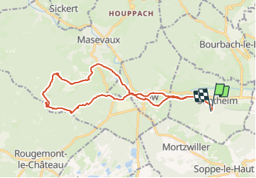
Tocht Stappen van 17,7 km beschikbaar op Grand Est, Haut-Rhin, Sentheim. Deze tocht wordt voorgesteld door helmut68.

Beschrijving

Belle randonnée au départ de Sentheim pour atteindre les ruines du  château de Montori  culminant à 792 m dans les hauteurs de Masevaux.
Utilisez le balisage " triangle bleu " jusqu' au terrain de football de Lauw . A partir de là suivez le balisage " rectangle bleu " - GR531 jusqu'au Lac Bleu puis le balisage " anneau rouge " jusqu'au parking du parcours de santé de Masevaux . Avant vous allez passer devant le collège et la gendarmerie de Masevaux .
A partir du parking empruntez le chemin forestier balisé " croix jaune " jusqu'à l'abri du Grambaechle où vous pourrez pique-niquer et remplir votre gourde à la fontaine .
De là suivez le balisage " rectangle jaune blanc jaune " jusqu'au château de Montori et sa légende ...
Une très belle vue sur le Rossberg , les villages de début de vallée de la Doller , une partie de  la plaine d'Alsace ainsi que les Alpes suisses , vous attend ...
Le retour se fera en empruntant tout le temps le balisage " triangle bleu " jusqu'à Sentheim .
Alors à vos chaussures !

Hoogteprofiel

Foto's

Plaatsbepaling

Land:
France
Regio :
Grand Est
Departement/Provincie :
Haut-Rhin
Gemeente :
Sentheim
Locatie:
Unknown
Vertrek:(UTM)
353909 ; 5290705 (32T) N.

Wandeltochten in de omgeving

Tocht Stappen Masevaux-Niederbruck - Masevaux - Rossberg par le belvédère du Fuchsfelsen - Photo
Stappen
Bart2015

Stappen

Medium
(1)
Masevaux-Niederbruck, Grand Est, Haut-Rhin, France
19,9 km | 34 km-effort
4h 44min
Ja
Tocht Stappen Sentheim - Sentheim Rossberg - Photo
Stappen
helmut68

Stappen

Medium
(1)
Sentheim, Grand Est, Haut-Rhin, France
27 km | 40 km-effort
6h 11min
Ja
Tocht Stappen Lauw - 2022-07-14 Marche Lauw Refuge CAF Baerenkopf - Photo
Stappen
GUIDE
holtzv

Stappen

Zeer moeilijk
Lauw, Grand Est, Haut-Rhin, France
18,4 km | 31 km-effort
5h 35min
Neen
Tocht Te voet Sentheim - Sentier géologique du Wolfloch - Photo
Te voet
PRO

Te voet

Gemakkelijk
Sentheim, Grand Est, Haut-Rhin, France
3,8 km | 4,8 km-effort
1h 5min
Neen
Tocht Te voet Sentheim - Sentheim - Bergwald - Eichwald - Guevenheim - Sentheim - Photo
Te voet
patrickbeyrath

Te voet

Gemakkelijk
(1)
Sentheim, Grand Est, Haut-Rhin, France
13,4 km | 16,6 km-effort
Onbekend
Ja
Tocht Stappen Sentheim - Knapphutte Saegenkopf Hütte - Photo
Stappen
helmut68

Stappen

Medium
Sentheim, Grand Est, Haut-Rhin, France
13,8 km | 17,2 km-effort
5h 11min
Ja
Tocht Mountainbike Sentheim - AperoDioller - Photo
Mountainbike
helmut68

Mountainbike

Gemakkelijk
Sentheim, Grand Est, Haut-Rhin, France
24 km | 27 km-effort
1h 23min
Ja
Tocht Stappen Sentheim - Baerenkopf  - Photo
Stappen
helmut68

Stappen

Moeilijk
Sentheim, Grand Est, Haut-Rhin, France
33 km | 49 km-effort
7h 0min
Ja
Tocht Stappen Sentheim - Lac Seigneurie Soultzbach - Photo
Stappen
helmut68

Stappen

Gemakkelijk
Sentheim, Grand Est, Haut-Rhin, France
10,9 km | 12,7 km-effort
3h 26min
Ja


Sluiten
Mijn abonnementen