Tocht Andere activiteiten Letterkenny Municipal District - fanad route - Photo
 ciaranmcelwaine
ciaranmcelwaine

Gebruiker

© OpenStreetMap contributors
Lengte
Lengte
15,8 km
Max. hoogte
Max. hoogte
92 m
Positief hoogteverschil
243 m
Km-Effort
Km-Effort  
19 km
Min. hoogte
Min. hoogte
6 m
Negatief hoogteverschil
247 m
Boucle
Boucle
Ja
Datum van aanmaak :
2014-12-10 00:00:00.0
Laatste wijziging :
2014-12-10 00:00:00.0

(0 Bericht)

Andere activiteiten
Andere activiteiten
4h25
Moeilijkheid : Onbekend

Scan deze QR-code om de tocht te openen in de SityTrail-applicatie

Gratisgps-wandelapplicatie

Logo SityTrail SityTrail

IGN / Geografische instituten

SityTrail uit de App Store downloaden SityTrail uit Google Play downloaden

Logo SityTrail SityTrail World

De wereld gaat voor u open

SityTrail uit de App Store downloaden SityTrail uit Google Play downloaden SityTrail op Huawei AppGallery downloaden

Over ons

Tocht Andere activiteiten van 15,8 km beschikbaar op Onbekend, County Donegal, Letterkenny Municipal District. Deze tocht wordt voorgesteld door ciaranmcelwaine.

Hoogteprofiel

Foto's

POI's

POI Letterkenny Municipal District - poi_979448 - Photo
ciaranmcelwaine
LETTERKENNY MUNICIPAL DISTRICT 

Plaatsbepaling

Land:
Ireland
Regio :
Onbekend
Departement/Provincie :
County Donegal
Gemeente :
Letterkenny Municipal District
Locatie:
Fanad North ED
Vertrek:(Dec)
Vertrek:(UTM)
584323 ; 6123702 (29U) N.

Wandeltochten in de omgeving

Tocht Fiets Letterkenny Municipal District - Araheera Bicycle Route Route 1 - Photo
Fiets
ciaranmcelwaine

Fiets

Heel gemakkelijk
Letterkenny Municipal District, Onbekend, County Donegal, Ireland
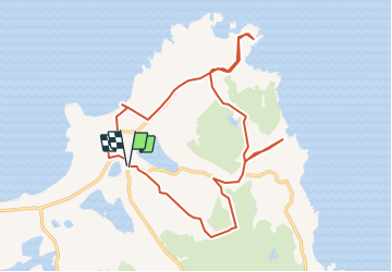
16,2 km | 19,5 km-effort
47min
Ja


Sluiten
Mijn abonnementen