Tocht Stappen Caramany - CARAMANY 66 - balcons retenue sur l'Agly  - Photo

CARAMANY 66 - balcons retenue sur l'Agly

 jeff66
jeff66

Gebruiker

© OpenStreetMap contributors
Lengte
Lengte
25 km
Max. hoogte
Max. hoogte
381 m
Positief hoogteverschil
665 m
Km-Effort
Km-Effort  
34 km
Min. hoogte
Min. hoogte
137 m
Negatief hoogteverschil
666 m
Boucle
Boucle
Ja
Datum van aanmaak :
2015-05-21 00:00:00.0
Laatste wijziging :
2015-05-21 00:00:00.0

(3 Bericht)

Stappen
Stappen
3h59
Moeilijkheid : Medium

Scan deze QR-code om de tocht te openen in de SityTrail-applicatie

Gratisgps-wandelapplicatie

Logo SityTrail SityTrail

IGN / Geografische instituten

SityTrail uit de App Store downloaden SityTrail uit Google Play downloaden

Logo SityTrail SityTrail World

De wereld gaat voor u open

SityTrail uit de App Store downloaden SityTrail uit Google Play downloaden SityTrail op Huawei AppGallery downloaden

Over ons

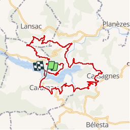
Tocht Stappen van 25 km beschikbaar op Occitanië, Pyrénées-Orientales, Caramany. Deze tocht wordt voorgesteld door jeff66.

Beschrijving

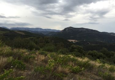
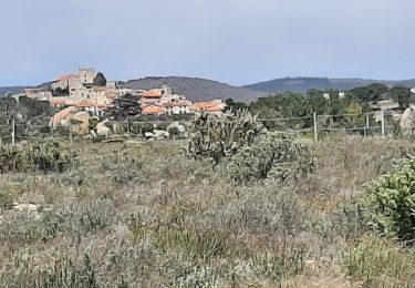
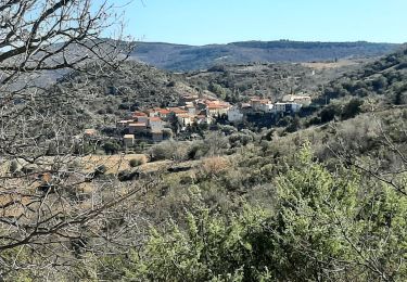
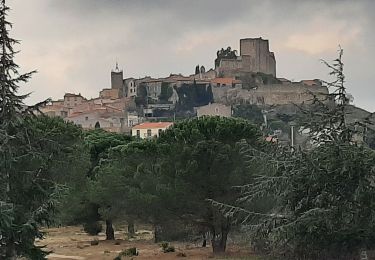
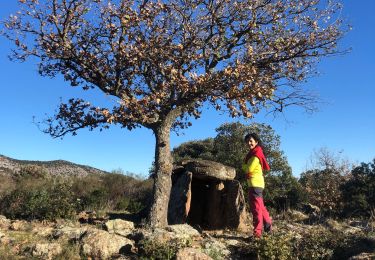
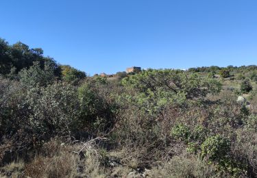
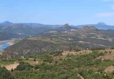
CARAMANY 66 - balcons retenue sur l'Agly - corbières - barrage - CASSAGNES

Hoogteprofiel

POI's

POI Caramany - Point 1 - Photo
jeff66
CARAMANY 
POI Caramany - Point 2 - Photo
jeff66
CARAMANY 
POI Rasiguères - Point 3 - Photo
jeff66
RASIGUÈRES 
POI Caramany - Point 4 - Photo
jeff66
CARAMANY 
POI Caramany - Point 5 - Photo
jeff66
CARAMANY 
POI Rasiguères - Point 6 - Photo
jeff66
RASIGUÈRES 
POI Caramany - Point 7 - Photo
jeff66
CARAMANY 
POI Lansac - Point 8 - Photo
jeff66
LANSAC 
POI Lansac - Point 9 - Photo
jeff66
LANSAC 
POI Lansac - Point 10 - Photo
jeff66
LANSAC 
POI Lansac - Point 11 - Photo
jeff66
LANSAC 
POI Rasiguères - Point 12 - Photo
jeff66
RASIGUÈRES 
POI Cassagnes - Point 13 - Photo
jeff66
CASSAGNES 
POI Cassagnes - Point 14 - Photo
jeff66
CASSAGNES 
POI Cassagnes - Point 15 - Photo
jeff66
CASSAGNES 

Plaatsbepaling

Land:
France
Regio :
Occitanië
Departement/Provincie :
Pyrénées-Orientales
Gemeente :
Caramany
Locatie:
Unknown
Vertrek:(Dec)
Vertrek:(UTM)
464970 ; 4732031 (31T) N.

Opmerkingen

Gelieve in te loggen om een commentaar of een beoordeling achter te laten


Wandeltochten in de omgeving

Tocht Stappen Trilla - 66 TRILLA - ANSIGNAN aqueduc romain - ballade en Fenouillédes  - Photo
Stappen
jeff66

Stappen

Moeilijk
(1)
Trilla, Occitanië, Pyrénées-Orientales, France
17,6 km | 26 km-effort
3h 49min
Ja
Tocht Stappen Bélesta - Boucle du Pic Aubeill - Photo
Stappen
bfrogneux

Stappen

Gemakkelijk
(1)
Bélesta, Occitanië, Pyrénées-Orientales, France
8 km | 10,9 km-effort
2h 24min
Ja
Tocht Stappen Cassagnes - pic d'abeille - Photo
Stappen
randovivi

Stappen

Heel gemakkelijk
(2)
Cassagnes, Occitanië, Pyrénées-Orientales, France
8,1 km | 10,8 km-effort
3h 0min
Ja
Tocht Stappen Montalba-le-Château - Montauban le château corral grandes or - Photo
Stappen
66Gribouille83

Stappen

Moeilijk
Montalba-le-Château, Occitanië, Pyrénées-Orientales, France
12,9 km | 16,3 km-effort
3h 42min
Ja
Tocht Stappen Caramany - caramany - Photo
Stappen
66Gribouille83

Stappen

Medium
Caramany, Occitanië, Pyrénées-Orientales, France
8 km | 11,4 km-effort
3h 27min
Ja
Tocht Stappen Montalba-le-Château - montant a - Photo
Stappen
66Gribouille83

Stappen

Moeilijk
Montalba-le-Château, Occitanië, Pyrénées-Orientales, France
11,8 km | 14,7 km-effort
5h 2min
Neen
Tocht Stappen Ansignan - 20230105 Ansignan - Photo
Stappen
ThonyM

Stappen

Medium
Ansignan, Occitanië, Pyrénées-Orientales, France
17 km | 27 km-effort
4h 38min
Ja
Tocht Stappen Trévillach - SEQUIERE  - Photo
Stappen
MarcOBRECHT

Stappen

Medium
Trévillach, Occitanië, Pyrénées-Orientales, France
11,1 km | 14,4 km-effort
2h 48min
Ja
Tocht Stappen Cassagnes - F66 Cassagnes pic Aubeill - Photo
Stappen
ageo

Stappen

Gemakkelijk
Cassagnes, Occitanië, Pyrénées-Orientales, France
6,3 km | 8,4 km-effort
2h 20min
Neen


Sluiten
Mijn abonnementen