Tocht Stappen Senlis - rando bivouac - Photo
 doloop
doloop

Gebruiker

© OpenStreetMap contributors
Lengte
Lengte
21 km
Max. hoogte
Max. hoogte
114 m
Positief hoogteverschil
193 m
Km-Effort
Km-Effort  
23 km
Min. hoogte
Min. hoogte
50 m
Negatief hoogteverschil
203 m
Boucle
Boucle
Neen
Datum van aanmaak :
2015-04-08 00:00:00.0
Laatste wijziging :
2015-04-08 00:00:00.0

(0 Bericht)

Stappen
Stappen
5h04
Moeilijkheid : Onbekend

Scan deze QR-code om de tocht te openen in de SityTrail-applicatie

Gratisgps-wandelapplicatie

Logo SityTrail SityTrail

IGN / Geografische instituten

SityTrail uit de App Store downloaden SityTrail uit Google Play downloaden

Logo SityTrail SityTrail World

De wereld gaat voor u open

SityTrail uit de App Store downloaden SityTrail uit Google Play downloaden SityTrail op Huawei AppGallery downloaden

Over ons

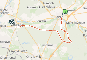
Tocht Stappen van 21 km beschikbaar op Hauts-de-France, Oise, Senlis. Deze tocht wordt voorgesteld door doloop.

Beschrijving

Départ gare de chantilly, prendre bus N°15 (19h40) jusqu'à senlis gare routière.

Hoogteprofiel

Plaatsbepaling

Land:
France
Regio :
Hauts-de-France
Departement/Provincie :
Oise
Gemeente :
Senlis
Locatie:
Unknown
Vertrek:(Dec)
Vertrek:(UTM)
470306 ; 5450477 (31U) N.

Wandeltochten in de omgeving

Tocht Stappen Villers-Saint-Frambourg-Ognon - MR_OGNON (par BALAGNY-sur-AUNETTE)_5.4Km - Photo
Stappen

Stappen

Medium
(3)
Villers-Saint-Frambourg-Ognon, Hauts-de-France, Oise, France
5,4 km | 6,4 km-effort
1h 27min
Ja
Tocht Stappen Senlis - SM_ERMENONVILLE Mais Forest BIAT_7.9Km - Photo
Stappen
GR77LP

Stappen

Medium
(2)
Senlis, Hauts-de-France, Oise, France
7,9 km | 8,9 km-effort
2h 1min
Ja
Tocht Stappen Mont-l'Évêque - SM_MONT-L'EVEQUE_8Km - Photo
Stappen
GR77LP

Stappen

Medium
(4)
Mont-l'Évêque, Hauts-de-France, Oise, France
8,1 km | 9,1 km-effort
1h 59min
Ja
Tocht Te voet Senlis - SENLIS CITE ROYALE(FFK) - Photo
Te voet
GR77LP

Te voet

Heel gemakkelijk
(1)
Senlis, Hauts-de-France, Oise, France
4,6 km | 5,2 km-effort
2h 0min
Ja
Tocht Stappen Chamant - Chamant Supermini-rando - Photo
Stappen
CC.RIDER

Stappen

Gemakkelijk
(8)
Chamant, Hauts-de-France, Oise, France
8 km | 9,3 km-effort
2h 7min
Ja
Tocht Te voet Senlis - De Orrouy à Coye - Photo
Te voet
PRO

Te voet

Gemakkelijk
Senlis, Hauts-de-France, Oise, France
10,1 km | 11,2 km-effort
2h 33min
Neen
Tocht Te voet Aumont-en-Halatte - Chemin Royal - Photo
Te voet
PRO

Te voet

Gemakkelijk
Aumont-en-Halatte, Hauts-de-France, Oise, France
3,5 km | 4 km-effort
54min
Neen
Tocht Stappen Villers-Saint-Frambourg-Ognon - SM_OGNON-(ex BALAGNY-sur-AUNETTE)_8.3Km - Photo
Stappen
GR77LP

Stappen

Medium
(4)
Villers-Saint-Frambourg-Ognon, Hauts-de-France, Oise, France
8,3 km | 9,6 km-effort
2h 10min
Ja
Tocht Stappen Pontarmé - La Croix de Pontarmé_Le chêne de grès_trace GPS_9,6km - Photo
Stappen
Pousscailleux

Stappen

Gemakkelijk
Pontarmé, Hauts-de-France, Oise, France
9,6 km | 10,7 km-effort
2h 37min
Ja


Sluiten
Mijn abonnementen