Tocht Stappen Cabestany - CABESTANY 66 - ronde par les chemins - Photo

CABESTANY 66 - ronde par les chemins

 jeff66
jeff66

Gebruiker

© OpenStreetMap contributors
Lengte
Lengte
12,8 km
Max. hoogte
Max. hoogte
49 m
Positief hoogteverschil
79 m
Km-Effort
Km-Effort  
13,9 km
Min. hoogte
Min. hoogte
4 m
Negatief hoogteverschil
77 m
Boucle
Boucle
Ja
Datum van aanmaak :
2015-05-21 00:00:00.0
Laatste wijziging :
2015-05-21 00:00:00.0

(0 Bericht)

Stappen
Stappen
2h00
Moeilijkheid : Gemakkelijk

Scan deze QR-code om de tocht te openen in de SityTrail-applicatie

Gratisgps-wandelapplicatie

Logo SityTrail SityTrail

IGN / Geografische instituten

SityTrail uit de App Store downloaden SityTrail uit Google Play downloaden

Logo SityTrail SityTrail World

De wereld gaat voor u open

SityTrail uit de App Store downloaden SityTrail uit Google Play downloaden SityTrail op Huawei AppGallery downloaden

Over ons

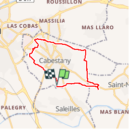
Tocht Stappen van 12,8 km beschikbaar op Occitanië, Pyrénées-Orientales, Cabestany. Deze tocht wordt voorgesteld door jeff66.

Beschrijving

CABESTANY 66 - germanor - berges de la Fosseille - Mas Alart - passage à gué - chapelle de l'Arca - les garrigues - vue sur les Albères - via domotia - château de Lacroix - table d'orientation - Mas du Texas - CABESTANY - Mas Ferrer - Costa Roja - Medipôle - Mas Campanaud - piste cyclable - Parcours sportif et paysager de sainte Camille - Mas Laffitte - El molinas - la Colomina del Pou - complexe sportif de Germanor

Hoogteprofiel

Foto's

Plaatsbepaling

Land:
France
Regio :
Occitanië
Departement/Provincie :
Pyrénées-Orientales
Gemeente :
Cabestany
Locatie:
Unknown
Vertrek:(Dec)
Vertrek:(UTM)
495246 ; 4723874 (31T) N.

Wandeltochten in de omgeving

Tocht Stappen Montescot - 66 VILLENEUVE-DE-LA-RAHO grand tour du lac en Sens horaire  - Photo
Stappen
jeff66

Stappen

Gemakkelijk
(1)
Montescot, Occitanië, Pyrénées-Orientales, France
6,7 km | 7,5 km-effort
1h 4min
Ja
Tocht Stappen Théza - 66 THEZA - CORNEILLA-DEL-VERCOL - Photo
Stappen
jeff66

Stappen

Gemakkelijk
(2)
Théza, Occitanië, Pyrénées-Orientales, France
7 km | 7,5 km-effort
1h 8min
Ja
Tocht Stappen Cabestany - Chemins autour de Cabestany - Photo
Stappen
tracegps

Stappen

Medium
(2)
Cabestany, Occitanië, Pyrénées-Orientales, France
11,8 km | 12,7 km-effort
3h 0min
Ja
Tocht Stappen Perpignan - Perpignan 01.10.2017  - Photo
Stappen
jeff66

Stappen

Gemakkelijk
(1)
Perpignan, Occitanië, Pyrénées-Orientales, France
6,7 km | 7,5 km-effort
1h 39min
Neen
Tocht Stappen Villeneuve-de-la-Raho - 66 VILLENEUVE-DE-LA-RAHO - grand tour périphérique du lac par les lignes de crêtes  - Photo
Stappen
jeff66

Stappen

Gemakkelijk
(2)
Villeneuve-de-la-Raho, Occitanië, Pyrénées-Orientales, France
10 km | 11,5 km-effort
1h 44min
Ja
Tocht Stappen Saleilles - 66 SALEILLES - St-NAZAIRE, entre FOSSEILLE et REART - Photo
Stappen
jeff66

Stappen

Gemakkelijk
(1)
Saleilles, Occitanië, Pyrénées-Orientales, France
7,3 km | 7,7 km-effort
1h 8min
Ja
Tocht Quad Villeneuve-de-la-Raho -  Villeneuve-de-la-Raho-Collioure (Septembre/Juin) - Photo
Quad
Quad Ride

Quad

Medium
(1)
Villeneuve-de-la-Raho, Occitanië, Pyrénées-Orientales, France
44 km | 51 km-effort
1h 45min
Neen
Tocht Stappen Corneilla-del-Vercol - thématique mo tescot du 18 02 2023 - Photo
Stappen
66Gribouille83

Stappen

Medium
(1)
Corneilla-del-Vercol, Occitanië, Pyrénées-Orientales, France
8,9 km | 9,4 km-effort
1h 57min
Ja
Tocht Stappen Perpignan - Perpignan  - Photo
Stappen
ombrabella

Stappen

Heel gemakkelijk
Perpignan, Occitanië, Pyrénées-Orientales, France
18 km | 19,9 km-effort
2h 23min
Neen


Sluiten
Mijn abonnementen