Tocht Stappen Kenmare Municipal District - Bolus Head loop - Photo
 FabienneD
FabienneD

Gebruiker

© OpenStreetMap contributors
Lengte
Lengte
7,8 km
Max. hoogte
Max. hoogte
278 m
Positief hoogteverschil
326 m
Km-Effort
Km-Effort  
12,2 km
Min. hoogte
Min. hoogte
44 m
Negatief hoogteverschil
326 m
Boucle
Boucle
Ja
Datum van aanmaak :
2015-06-14 00:00:00.0
Laatste wijziging :
2015-06-14 00:00:00.0

(0 Bericht)

Stappen
Stappen
2h31
Moeilijkheid : Medium

Scan deze QR-code om de tocht te openen in de SityTrail-applicatie

Gratisgps-wandelapplicatie

Logo SityTrail SityTrail

IGN / Geografische instituten

SityTrail uit de App Store downloaden SityTrail uit Google Play downloaden

Logo SityTrail SityTrail World

De wereld gaat voor u open

SityTrail uit de App Store downloaden SityTrail uit Google Play downloaden SityTrail op Huawei AppGallery downloaden

Over ons

Tocht Stappen van 7,8 km beschikbaar op Onbekend, County Kerry, Kenmare Municipal District. Deze tocht wordt voorgesteld door FabienneD.

Beschrijving

Magnifiques vues sur la cote, les îles Skelling, les champs de moutons, etc.

Hoogteprofiel

Plaatsbepaling

Land:
Ireland
Regio :
Onbekend
Departement/Provincie :
County Kerry
Gemeente :
Kenmare Municipal District
Locatie:
BaILe an Sceilg
Vertrek:(UTM)
407818 ; 5741208 (29U) N.

Wandeltochten in de omgeving

Tocht Andere activiteiten Kenmare Municipal District - Caherdaniel - Sneem - Photo
Andere activiteiten
bffcuc

Andere activiteiten

Heel gemakkelijk
Kenmare Municipal District, Onbekend, County Kerry, Ireland
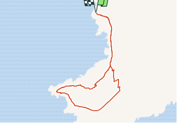
18,5 km | 25 km-effort
5h 30min
Neen
Tocht Andere activiteiten Kenmare Municipal District - Waterville Caherdaniel - Photo
Andere activiteiten
bffcuc

Andere activiteiten

Heel gemakkelijk
Kenmare Municipal District, Onbekend, County Kerry, Ireland
15 km | 20 km-effort
4h 38min
Neen
Tocht Andere activiteiten Kenmare Municipal District - Derrymore - Waterville - Photo
Andere activiteiten
bffcuc

Andere activiteiten

Heel gemakkelijk
Kenmare Municipal District, Onbekend, County Kerry, Ireland
17,6 km | 26 km-effort
5h 38min
Neen
Tocht Auto Kenmare Municipal District - j03-3 - Photo
Auto
DUPORT16

Auto

Heel gemakkelijk
Kenmare Municipal District, Onbekend, County Kerry, Ireland
78 km | 92 km-effort
3h 3min
Neen
Tocht Auto Kenmare Municipal District - Catherdaniel - Killarney WAW part 4 - Photo
Auto
Bernard Lejeune

Auto

Heel gemakkelijk
Kenmare Municipal District, Onbekend, County Kerry, Ireland
160 km | 186 km-effort
Onbekend
Neen
Tocht Stappen Kenmare Municipal District - KW07 - Caherdaniel - Sneem - Photo
Stappen
Tournan

Stappen

Medium
Kenmare Municipal District, Onbekend, County Kerry, Ireland
18,2 km | 24 km-effort
5h 10min
Neen
Tocht Stappen Kenmare Municipal District - KW06 - Waterville - Caherdaniel - Photo
Stappen
Tournan

Stappen

Medium
Kenmare Municipal District, Onbekend, County Kerry, Ireland
13,2 km | 17,7 km-effort
3h 48min
Neen
Tocht Stappen Kenmare Municipal District - KW05 - Cahersiveen - Waterville - Photo
Stappen
Tournan

Stappen

Medium
Kenmare Municipal District, Onbekend, County Kerry, Ireland
18,1 km | 26 km-effort
5h 24min
Neen
Tocht Stappen Kenmare Municipal District - Waterville - Staigue - Photo
Stappen
luvidine

Stappen

Medium
Kenmare Municipal District, Onbekend, County Kerry, Ireland
19,9 km | 27 km-effort
5h 44min
Neen


Sluiten
Mijn abonnementen