Tocht Fiets Anzex - Canal Garonne de casteljaloux à Castelssarasin - Photo

Canal Garonne de casteljaloux à Castelssarasin

 destras
destras

Gebruiker

© OpenStreetMap contributors
Lengte
Lengte
116 km
Max. hoogte
Max. hoogte
148 m
Positief hoogteverschil
900 m
Km-Effort
Km-Effort  
127 km
Min. hoogte
Min. hoogte
30 m
Negatief hoogteverschil
880 m
Boucle
Boucle
Neen
Datum van aanmaak :
2016-03-09 00:00:00.0
Laatste wijziging :
2016-03-09 00:00:00.0

(0 Bericht)

Fiets
Fiets
7h14
Moeilijkheid : Gemakkelijk

Scan deze QR-code om de tocht te openen in de SityTrail-applicatie

Gratisgps-wandelapplicatie

Logo SityTrail SityTrail

IGN / Geografische instituten

SityTrail uit de App Store downloaden SityTrail uit Google Play downloaden

Logo SityTrail SityTrail World

De wereld gaat voor u open

SityTrail uit de App Store downloaden SityTrail uit Google Play downloaden SityTrail op Huawei AppGallery downloaden

Over ons

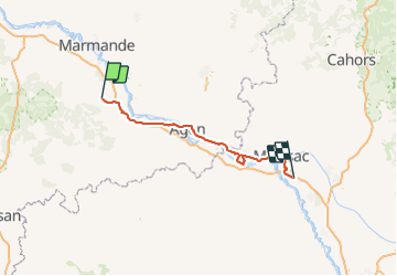
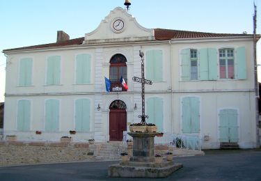
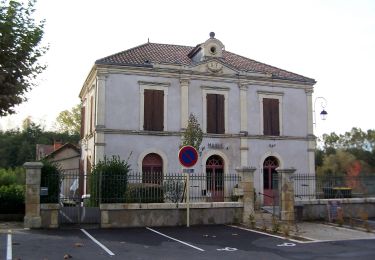
Tocht Fiets van 116 km beschikbaar op Nieuw-Aquitanië, Lot-et-Garonne, Anzex. Deze tocht wordt voorgesteld door destras.

Beschrijving

de casteljaloux à Castelssarasin
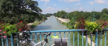
en vélo à assistance électrique VAE par le canal latéral à la Garonne

Hoogteprofiel

Foto's

POI's

POI Agen - Pont canal d'Agen - Photo
destras
POI Auvillar - Auvillar - Photo
destras
AUVILLAR 
POI Moissac - Moissac - Photo
destras
MOISSAC 

Plaatsbepaling

Land:
France
Regio :
Nieuw-Aquitanië
Departement/Provincie :
Lot-et-Garonne
Gemeente :
Anzex
Locatie:
Unknown
Vertrek:(Dec)
Vertrek:(UTM)
276098 ; 4910424 (31T) N.

Wandeltochten in de omgeving

Tocht Te voet Puch-d'Agenais - Puch-d’Agenais, dans les terrasses de Garonne - 6.2km - Photo
Te voet
PRO

Te voet

Gemakkelijk
Puch-d'Agenais, Nieuw-Aquitanië, Lot-et-Garonne, France
6,1 km | 7 km-effort
1h 35min
Ja
Tocht Te voet Villefranche-du-Queyran - Villefranche, la bastide du Queyran - 15.2 km - Photo
Te voet
PRO

Te voet

Gemakkelijk
Villefranche-du-Queyran, Nieuw-Aquitanië, Lot-et-Garonne, France
15 km | 18 km-effort
4h 5min
Ja
Tocht Te voet Anzex - Anzex, la promenade de Pèleperdrix (7,9 km, balisage jaune) - Photo
Te voet
PRO

Te voet

Gemakkelijk
Anzex, Nieuw-Aquitanië, Lot-et-Garonne, France
7,6 km | 9,4 km-effort
2h 8min
Neen
Tocht Mountainbike Puch-d'Agenais - Puch-d'Agenais, dans les terrasses de Garonne - Pays de la vallée du Lot  - Photo
Mountainbike
tracegps

Mountainbike

Gemakkelijk
Puch-d'Agenais, Nieuw-Aquitanië, Lot-et-Garonne, France
6,1 km | 7 km-effort
30min
Ja
Tocht Stappen Puch-d'Agenais - Puch-d'Agenais, dans les terrasses de Garonne - Pays de la vallée du Lot  - Photo
Stappen
tracegps

Stappen

Gemakkelijk
Puch-d'Agenais, Nieuw-Aquitanië, Lot-et-Garonne, France
6,1 km | 7 km-effort
2h 0min
Ja
Tocht Mountainbike Villefranche-du-Queyran - Villefranche, la bastide du Queyran - Pays Val de Garonne - Gascogne - Photo
Mountainbike
tracegps

Mountainbike

Moeilijk
Villefranche-du-Queyran, Nieuw-Aquitanië, Lot-et-Garonne, France
15,1 km | 18,2 km-effort
1h 55min
Ja
Tocht Stappen Villefranche-du-Queyran - Villefranche, la bastide du Queyran - Pays Val de Garonne - Gascogne - Photo
Stappen
tracegps

Stappen

Moeilijk
Villefranche-du-Queyran, Nieuw-Aquitanië, Lot-et-Garonne, France
15,1 km | 18,2 km-effort
4h 0min
Ja
Tocht Stappen Villefranche-du-Queyran - Villefranche du queran - Photo
Stappen
christiane01

Stappen

Medium
Villefranche-du-Queyran, Nieuw-Aquitanië, Lot-et-Garonne, France
6,7 km | 7,7 km-effort
1h 58min
Ja
Tocht Stappen Villefranche-du-Queyran - villefranche9km - Photo
Stappen
garigotte

Stappen

Heel gemakkelijk
Villefranche-du-Queyran, Nieuw-Aquitanië, Lot-et-Garonne, France
9,2 km | 10,8 km-effort
2h 11min
Ja


Sluiten
Mijn abonnementen