Tocht Sneeuwschoenen Val de Bagnes - N° 1 Mayens du Châble - Photo
 verbier
verbier

Gebruiker

© OpenStreetMap contributors
Lengte
Lengte
6,6 km
Max. hoogte
Max. hoogte
1705 m
Positief hoogteverschil
871 m
Km-Effort
Km-Effort  
15,4 km
Min. hoogte
Min. hoogte
864 m
Negatief hoogteverschil
38 m
Boucle
Boucle
Neen
Datum van aanmaak :
2014-12-10 00:00:00.0
Laatste wijziging :
2014-12-10 00:00:00.0

(0 Bericht)

Sneeuwschoenen
Sneeuwschoenen
3h30
Moeilijkheid : Onbekend

Scan deze QR-code om de tocht te openen in de SityTrail-applicatie

Gratisgps-wandelapplicatie

Logo SityTrail SityTrail

IGN / Geografische instituten

SityTrail uit de App Store downloaden SityTrail uit Google Play downloaden

Logo SityTrail SityTrail World

De wereld gaat voor u open

SityTrail uit de App Store downloaden SityTrail uit Google Play downloaden SityTrail op Huawei AppGallery downloaden

Over ons

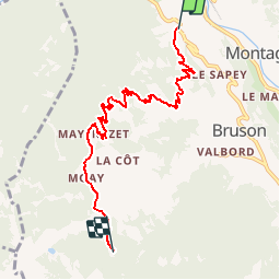
Tocht Sneeuwschoenen van 6,6 km beschikbaar op Valais/Wallis, Entremont, Val de Bagnes. Deze tocht wordt voorgesteld door verbier.

Beschrijving

Le Châble Bahnhof - Clouchère''s Strasse - Les Barmes (1''066 m) - La Diète (1''231 m) - Les Combes - Le Mayentset (1''567 m) - Moay''s Restaurant - La Vinteure - Mayens de Bruson

Hoogteprofiel

POI's

POI Val de Bagnes - Arrivée - Photo
verbier
VAL DE BAGNES 
POI Val de Bagnes - Départ - Photo
verbier
VAL DE BAGNES 
POI Val de Bagnes - Télésiège La Côt - Photo
verbier
VAL DE BAGNES 
POI Val de Bagnes - Office du tourisme - Photo
verbier
VAL DE BAGNES 
POI Val de Bagnes - Parking - Photo
verbier
VAL DE BAGNES 
POI Val de Bagnes - Arrêt Bus, Bruson télé - Photo
verbier
POI Val de Bagnes - Moay - Photo
verbier
VAL DE BAGNES 
POI Val de Bagnes - Restaurant La Côt - Photo
verbier
VAL DE BAGNES 
POI Val de Bagnes - Gare du Châble - Photo
verbier
VAL DE BAGNES 

Plaatsbepaling

Land:
Switzerland
Regio :
Valais/Wallis
Departement/Provincie :
Entremont
Gemeente :
Val de Bagnes
Locatie:
Unknown
Vertrek:(Dec)
Vertrek:(UTM)
361517 ; 5104188 (32T) N.

Wandeltochten in de omgeving

Tocht Te voet Val de Bagnes - Vollèges - Levron - Photo
Te voet
PRO

Te voet

Gemakkelijk
Val de Bagnes, Valais/Wallis, Entremont, Switzerland
3,3 km | 7,8 km-effort
1h 46min
Neen
Tocht Te voet Val de Bagnes - Vollèges - Levron - Photo
Te voet
PRO

Te voet

Gemakkelijk
Val de Bagnes, Valais/Wallis, Entremont, Switzerland
5,4 km | 10,3 km-effort
2h 20min
Neen
Tocht Te voet Orsières - Chemins pédestre, commune d'Orsières - Photo
Te voet
PRO

Te voet

Gemakkelijk
Orsières, Valais/Wallis, Entremont, Switzerland
5,4 km | 14,1 km-effort
3h 12min
Neen
Tocht Te voet Val de Bagnes - Ancien Bisse du Levron - Photo
Te voet
PRO

Te voet

Gemakkelijk
Val de Bagnes, Valais/Wallis, Entremont, Switzerland
10,7 km | 13,4 km-effort
3h 2min
Neen
Tocht Stappen Val de Bagnes - Le Châble – Cabane de Louvie / Jour 2 - Photo
Stappen
Greg813

Stappen

Moeilijk
Val de Bagnes, Valais/Wallis, Entremont, Switzerland
12,4 km | 21 km-effort
3h 37min
Neen
Tocht Te voet Val de Bagnes - Promenade de la Dranse - Photo
Te voet
PRO

Te voet

Gemakkelijk
Val de Bagnes, Valais/Wallis, Entremont, Switzerland
7,1 km | 9,4 km-effort
2h 8min
Neen
Tocht Te voet Val de Bagnes - Chemins pédestres, région Bagnes - Photo
Te voet
PRO

Te voet

Gemakkelijk
Val de Bagnes, Valais/Wallis, Entremont, Switzerland
6,2 km | 15 km-effort
3h 24min
Neen
Tocht Te voet Val de Bagnes - Bruson - Moay - Photo
Te voet
PRO

Te voet

Gemakkelijk
Val de Bagnes, Valais/Wallis, Entremont, Switzerland
3,6 km | 10 km-effort
2h 16min
Neen
Tocht Stappen Riddes - Croix de Coeur - Pierre Avoi - Photo
Stappen
jptritten

Stappen

Medium
(2)
Riddes, Valais/Wallis, Martigny, Switzerland
6,4 km | 10,9 km-effort
2h 26min
Ja


Sluiten
Mijn abonnementen