


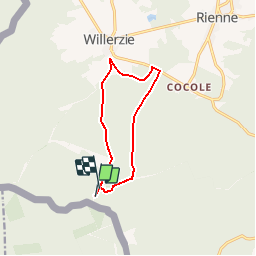


23 km | 30 km-effort

Randonnées de Natura 2000 GUIDE+


Gratisgps-wandelapplicatie
 SityTrail
IGN / Geografische instituten
SityTrail World
De wereld gaat voor u open
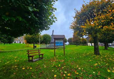
Tocht Stappen van 9 km beschikbaar op Wallonië, Namen, Gedinne. Deze tocht wordt voorgesteld door Natura 2000.
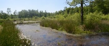
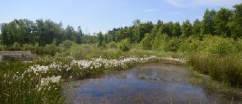
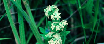
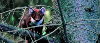
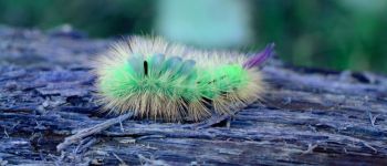
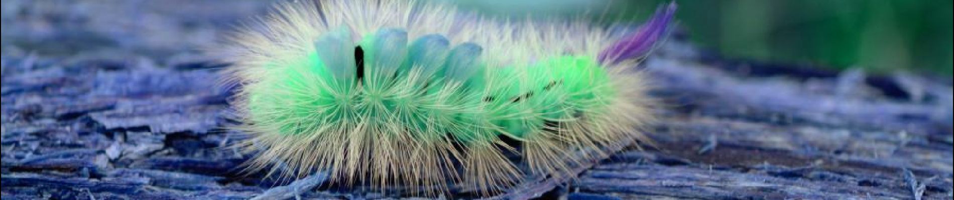
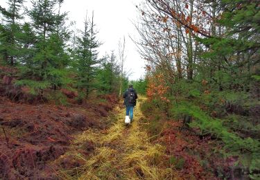
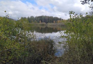
Le site Natura 2000 "Vallée de la Hulle" abrite essentiellement des habitats forestiers ardennais comme la hêtraie à luzule que le circuit proposé vous invite
à découvrir. Vous marcherez sous les frondaisons et vous découvrirez aussi des bas-marais bordés de linaigrettes ou des zones humides à la végétation
particulière.
 "
data-pinterest-text="Pin it"
data-tweet-text="share on twitter"
data-facebook-share-url="https://www.sitytrail.com/nl/trails/472278-gedinne--gedinne-x-circuit-natura-2000-xdes-sites-qui-valent-le-detourx-x-na10/?photo=1#lg=1&slide=1"
data-twitter-share-url="https://www.sitytrail.com/nl/trails/472278-gedinne--gedinne-x-circuit-natura-2000-xdes-sites-qui-valent-le-detourx-x-na10/?photo=1#lg=1&slide=1"
data-googleplus-share-url="https://www.sitytrail.com/nl/trails/472278-gedinne--gedinne-x-circuit-natura-2000-xdes-sites-qui-valent-le-detourx-x-na10/?photo=1#lg=1&slide=1"
data-pinterest-share-url="https://www.sitytrail.com/nl/trails/472278-gedinne--gedinne-x-circuit-natura-2000-xdes-sites-qui-valent-le-detourx-x-na10/?photo=1#lg=1&slide=1">
"
data-pinterest-text="Pin it"
data-tweet-text="share on twitter"
data-facebook-share-url="https://www.sitytrail.com/nl/trails/472278-gedinne--gedinne-x-circuit-natura-2000-xdes-sites-qui-valent-le-detourx-x-na10/?photo=1#lg=1&slide=1"
data-twitter-share-url="https://www.sitytrail.com/nl/trails/472278-gedinne--gedinne-x-circuit-natura-2000-xdes-sites-qui-valent-le-detourx-x-na10/?photo=1#lg=1&slide=1"
data-googleplus-share-url="https://www.sitytrail.com/nl/trails/472278-gedinne--gedinne-x-circuit-natura-2000-xdes-sites-qui-valent-le-detourx-x-na10/?photo=1#lg=1&slide=1"
data-pinterest-share-url="https://www.sitytrail.com/nl/trails/472278-gedinne--gedinne-x-circuit-natura-2000-xdes-sites-qui-valent-le-detourx-x-na10/?photo=1#lg=1&slide=1">
 "
data-pinterest-text="Pin it"
data-tweet-text="share on twitter"
data-facebook-share-url="https://www.sitytrail.com/nl/trails/472278-gedinne--gedinne-x-circuit-natura-2000-xdes-sites-qui-valent-le-detourx-x-na10/?photo=2#lg=1&slide=2"
data-twitter-share-url="https://www.sitytrail.com/nl/trails/472278-gedinne--gedinne-x-circuit-natura-2000-xdes-sites-qui-valent-le-detourx-x-na10/?photo=2#lg=1&slide=2"
data-googleplus-share-url="https://www.sitytrail.com/nl/trails/472278-gedinne--gedinne-x-circuit-natura-2000-xdes-sites-qui-valent-le-detourx-x-na10/?photo=2#lg=1&slide=2"
data-pinterest-share-url="https://www.sitytrail.com/nl/trails/472278-gedinne--gedinne-x-circuit-natura-2000-xdes-sites-qui-valent-le-detourx-x-na10/?photo=2#lg=1&slide=2">
"
data-pinterest-text="Pin it"
data-tweet-text="share on twitter"
data-facebook-share-url="https://www.sitytrail.com/nl/trails/472278-gedinne--gedinne-x-circuit-natura-2000-xdes-sites-qui-valent-le-detourx-x-na10/?photo=2#lg=1&slide=2"
data-twitter-share-url="https://www.sitytrail.com/nl/trails/472278-gedinne--gedinne-x-circuit-natura-2000-xdes-sites-qui-valent-le-detourx-x-na10/?photo=2#lg=1&slide=2"
data-googleplus-share-url="https://www.sitytrail.com/nl/trails/472278-gedinne--gedinne-x-circuit-natura-2000-xdes-sites-qui-valent-le-detourx-x-na10/?photo=2#lg=1&slide=2"
data-pinterest-share-url="https://www.sitytrail.com/nl/trails/472278-gedinne--gedinne-x-circuit-natura-2000-xdes-sites-qui-valent-le-detourx-x-na10/?photo=2#lg=1&slide=2">
 "
data-pinterest-text="Pin it"
data-tweet-text="share on twitter"
data-facebook-share-url="https://www.sitytrail.com/nl/trails/472278-gedinne--gedinne-x-circuit-natura-2000-xdes-sites-qui-valent-le-detourx-x-na10/?photo=3#lg=1&slide=3"
data-twitter-share-url="https://www.sitytrail.com/nl/trails/472278-gedinne--gedinne-x-circuit-natura-2000-xdes-sites-qui-valent-le-detourx-x-na10/?photo=3#lg=1&slide=3"
data-googleplus-share-url="https://www.sitytrail.com/nl/trails/472278-gedinne--gedinne-x-circuit-natura-2000-xdes-sites-qui-valent-le-detourx-x-na10/?photo=3#lg=1&slide=3"
data-pinterest-share-url="https://www.sitytrail.com/nl/trails/472278-gedinne--gedinne-x-circuit-natura-2000-xdes-sites-qui-valent-le-detourx-x-na10/?photo=3#lg=1&slide=3">
"
data-pinterest-text="Pin it"
data-tweet-text="share on twitter"
data-facebook-share-url="https://www.sitytrail.com/nl/trails/472278-gedinne--gedinne-x-circuit-natura-2000-xdes-sites-qui-valent-le-detourx-x-na10/?photo=3#lg=1&slide=3"
data-twitter-share-url="https://www.sitytrail.com/nl/trails/472278-gedinne--gedinne-x-circuit-natura-2000-xdes-sites-qui-valent-le-detourx-x-na10/?photo=3#lg=1&slide=3"
data-googleplus-share-url="https://www.sitytrail.com/nl/trails/472278-gedinne--gedinne-x-circuit-natura-2000-xdes-sites-qui-valent-le-detourx-x-na10/?photo=3#lg=1&slide=3"
data-pinterest-share-url="https://www.sitytrail.com/nl/trails/472278-gedinne--gedinne-x-circuit-natura-2000-xdes-sites-qui-valent-le-detourx-x-na10/?photo=3#lg=1&slide=3">
 "
data-pinterest-text="Pin it"
data-tweet-text="share on twitter"
data-facebook-share-url="https://www.sitytrail.com/nl/trails/472278-gedinne--gedinne-x-circuit-natura-2000-xdes-sites-qui-valent-le-detourx-x-na10/?photo=4#lg=1&slide=4"
data-twitter-share-url="https://www.sitytrail.com/nl/trails/472278-gedinne--gedinne-x-circuit-natura-2000-xdes-sites-qui-valent-le-detourx-x-na10/?photo=4#lg=1&slide=4"
data-googleplus-share-url="https://www.sitytrail.com/nl/trails/472278-gedinne--gedinne-x-circuit-natura-2000-xdes-sites-qui-valent-le-detourx-x-na10/?photo=4#lg=1&slide=4"
data-pinterest-share-url="https://www.sitytrail.com/nl/trails/472278-gedinne--gedinne-x-circuit-natura-2000-xdes-sites-qui-valent-le-detourx-x-na10/?photo=4#lg=1&slide=4">
"
data-pinterest-text="Pin it"
data-tweet-text="share on twitter"
data-facebook-share-url="https://www.sitytrail.com/nl/trails/472278-gedinne--gedinne-x-circuit-natura-2000-xdes-sites-qui-valent-le-detourx-x-na10/?photo=4#lg=1&slide=4"
data-twitter-share-url="https://www.sitytrail.com/nl/trails/472278-gedinne--gedinne-x-circuit-natura-2000-xdes-sites-qui-valent-le-detourx-x-na10/?photo=4#lg=1&slide=4"
data-googleplus-share-url="https://www.sitytrail.com/nl/trails/472278-gedinne--gedinne-x-circuit-natura-2000-xdes-sites-qui-valent-le-detourx-x-na10/?photo=4#lg=1&slide=4"
data-pinterest-share-url="https://www.sitytrail.com/nl/trails/472278-gedinne--gedinne-x-circuit-natura-2000-xdes-sites-qui-valent-le-detourx-x-na10/?photo=4#lg=1&slide=4">
 "
data-pinterest-text="Pin it"
data-tweet-text="share on twitter"
data-facebook-share-url="https://www.sitytrail.com/nl/trails/472278-gedinne--gedinne-x-circuit-natura-2000-xdes-sites-qui-valent-le-detourx-x-na10/?photo=5#lg=1&slide=5"
data-twitter-share-url="https://www.sitytrail.com/nl/trails/472278-gedinne--gedinne-x-circuit-natura-2000-xdes-sites-qui-valent-le-detourx-x-na10/?photo=5#lg=1&slide=5"
data-googleplus-share-url="https://www.sitytrail.com/nl/trails/472278-gedinne--gedinne-x-circuit-natura-2000-xdes-sites-qui-valent-le-detourx-x-na10/?photo=5#lg=1&slide=5"
data-pinterest-share-url="https://www.sitytrail.com/nl/trails/472278-gedinne--gedinne-x-circuit-natura-2000-xdes-sites-qui-valent-le-detourx-x-na10/?photo=5#lg=1&slide=5">
"
data-pinterest-text="Pin it"
data-tweet-text="share on twitter"
data-facebook-share-url="https://www.sitytrail.com/nl/trails/472278-gedinne--gedinne-x-circuit-natura-2000-xdes-sites-qui-valent-le-detourx-x-na10/?photo=5#lg=1&slide=5"
data-twitter-share-url="https://www.sitytrail.com/nl/trails/472278-gedinne--gedinne-x-circuit-natura-2000-xdes-sites-qui-valent-le-detourx-x-na10/?photo=5#lg=1&slide=5"
data-googleplus-share-url="https://www.sitytrail.com/nl/trails/472278-gedinne--gedinne-x-circuit-natura-2000-xdes-sites-qui-valent-le-detourx-x-na10/?photo=5#lg=1&slide=5"
data-pinterest-share-url="https://www.sitytrail.com/nl/trails/472278-gedinne--gedinne-x-circuit-natura-2000-xdes-sites-qui-valent-le-detourx-x-na10/?photo=5#lg=1&slide=5">
 "
data-pinterest-text="Pin it"
data-tweet-text="share on twitter"
data-facebook-share-url="https://www.sitytrail.com/nl/trails/472278-gedinne--gedinne-x-circuit-natura-2000-xdes-sites-qui-valent-le-detourx-x-na10/?photo=6#lg=1&slide=6"
data-twitter-share-url="https://www.sitytrail.com/nl/trails/472278-gedinne--gedinne-x-circuit-natura-2000-xdes-sites-qui-valent-le-detourx-x-na10/?photo=6#lg=1&slide=6"
data-googleplus-share-url="https://www.sitytrail.com/nl/trails/472278-gedinne--gedinne-x-circuit-natura-2000-xdes-sites-qui-valent-le-detourx-x-na10/?photo=6#lg=1&slide=6"
data-pinterest-share-url="https://www.sitytrail.com/nl/trails/472278-gedinne--gedinne-x-circuit-natura-2000-xdes-sites-qui-valent-le-detourx-x-na10/?photo=6#lg=1&slide=6">
"
data-pinterest-text="Pin it"
data-tweet-text="share on twitter"
data-facebook-share-url="https://www.sitytrail.com/nl/trails/472278-gedinne--gedinne-x-circuit-natura-2000-xdes-sites-qui-valent-le-detourx-x-na10/?photo=6#lg=1&slide=6"
data-twitter-share-url="https://www.sitytrail.com/nl/trails/472278-gedinne--gedinne-x-circuit-natura-2000-xdes-sites-qui-valent-le-detourx-x-na10/?photo=6#lg=1&slide=6"
data-googleplus-share-url="https://www.sitytrail.com/nl/trails/472278-gedinne--gedinne-x-circuit-natura-2000-xdes-sites-qui-valent-le-detourx-x-na10/?photo=6#lg=1&slide=6"
data-pinterest-share-url="https://www.sitytrail.com/nl/trails/472278-gedinne--gedinne-x-circuit-natura-2000-xdes-sites-qui-valent-le-detourx-x-na10/?photo=6#lg=1&slide=6">
 "
data-pinterest-text="Pin it"
data-tweet-text="share on twitter"
data-facebook-share-url="https://www.sitytrail.com/nl/trails/472278-gedinne--gedinne-x-circuit-natura-2000-xdes-sites-qui-valent-le-detourx-x-na10/?photo=7#lg=1&slide=7"
data-twitter-share-url="https://www.sitytrail.com/nl/trails/472278-gedinne--gedinne-x-circuit-natura-2000-xdes-sites-qui-valent-le-detourx-x-na10/?photo=7#lg=1&slide=7"
data-googleplus-share-url="https://www.sitytrail.com/nl/trails/472278-gedinne--gedinne-x-circuit-natura-2000-xdes-sites-qui-valent-le-detourx-x-na10/?photo=7#lg=1&slide=7"
data-pinterest-share-url="https://www.sitytrail.com/nl/trails/472278-gedinne--gedinne-x-circuit-natura-2000-xdes-sites-qui-valent-le-detourx-x-na10/?photo=7#lg=1&slide=7">
"
data-pinterest-text="Pin it"
data-tweet-text="share on twitter"
data-facebook-share-url="https://www.sitytrail.com/nl/trails/472278-gedinne--gedinne-x-circuit-natura-2000-xdes-sites-qui-valent-le-detourx-x-na10/?photo=7#lg=1&slide=7"
data-twitter-share-url="https://www.sitytrail.com/nl/trails/472278-gedinne--gedinne-x-circuit-natura-2000-xdes-sites-qui-valent-le-detourx-x-na10/?photo=7#lg=1&slide=7"
data-googleplus-share-url="https://www.sitytrail.com/nl/trails/472278-gedinne--gedinne-x-circuit-natura-2000-xdes-sites-qui-valent-le-detourx-x-na10/?photo=7#lg=1&slide=7"
data-pinterest-share-url="https://www.sitytrail.com/nl/trails/472278-gedinne--gedinne-x-circuit-natura-2000-xdes-sites-qui-valent-le-detourx-x-na10/?photo=7#lg=1&slide=7">
 "
data-pinterest-text="Pin it"
data-tweet-text="share on twitter"
data-facebook-share-url="https://www.sitytrail.com/nl/trails/472278-gedinne--gedinne-x-circuit-natura-2000-xdes-sites-qui-valent-le-detourx-x-na10/?photo=8#lg=1&slide=8"
data-twitter-share-url="https://www.sitytrail.com/nl/trails/472278-gedinne--gedinne-x-circuit-natura-2000-xdes-sites-qui-valent-le-detourx-x-na10/?photo=8#lg=1&slide=8"
data-googleplus-share-url="https://www.sitytrail.com/nl/trails/472278-gedinne--gedinne-x-circuit-natura-2000-xdes-sites-qui-valent-le-detourx-x-na10/?photo=8#lg=1&slide=8"
data-pinterest-share-url="https://www.sitytrail.com/nl/trails/472278-gedinne--gedinne-x-circuit-natura-2000-xdes-sites-qui-valent-le-detourx-x-na10/?photo=8#lg=1&slide=8">
"
data-pinterest-text="Pin it"
data-tweet-text="share on twitter"
data-facebook-share-url="https://www.sitytrail.com/nl/trails/472278-gedinne--gedinne-x-circuit-natura-2000-xdes-sites-qui-valent-le-detourx-x-na10/?photo=8#lg=1&slide=8"
data-twitter-share-url="https://www.sitytrail.com/nl/trails/472278-gedinne--gedinne-x-circuit-natura-2000-xdes-sites-qui-valent-le-detourx-x-na10/?photo=8#lg=1&slide=8"
data-googleplus-share-url="https://www.sitytrail.com/nl/trails/472278-gedinne--gedinne-x-circuit-natura-2000-xdes-sites-qui-valent-le-detourx-x-na10/?photo=8#lg=1&slide=8"
data-pinterest-share-url="https://www.sitytrail.com/nl/trails/472278-gedinne--gedinne-x-circuit-natura-2000-xdes-sites-qui-valent-le-detourx-x-na10/?photo=8#lg=1&slide=8">
 "
data-pinterest-text="Pin it"
data-tweet-text="share on twitter"
data-facebook-share-url="https://www.sitytrail.com/nl/trails/472278-gedinne--gedinne-x-circuit-natura-2000-xdes-sites-qui-valent-le-detourx-x-na10/?photo=9#lg=1&slide=9"
data-twitter-share-url="https://www.sitytrail.com/nl/trails/472278-gedinne--gedinne-x-circuit-natura-2000-xdes-sites-qui-valent-le-detourx-x-na10/?photo=9#lg=1&slide=9"
data-googleplus-share-url="https://www.sitytrail.com/nl/trails/472278-gedinne--gedinne-x-circuit-natura-2000-xdes-sites-qui-valent-le-detourx-x-na10/?photo=9#lg=1&slide=9"
data-pinterest-share-url="https://www.sitytrail.com/nl/trails/472278-gedinne--gedinne-x-circuit-natura-2000-xdes-sites-qui-valent-le-detourx-x-na10/?photo=9#lg=1&slide=9">
"
data-pinterest-text="Pin it"
data-tweet-text="share on twitter"
data-facebook-share-url="https://www.sitytrail.com/nl/trails/472278-gedinne--gedinne-x-circuit-natura-2000-xdes-sites-qui-valent-le-detourx-x-na10/?photo=9#lg=1&slide=9"
data-twitter-share-url="https://www.sitytrail.com/nl/trails/472278-gedinne--gedinne-x-circuit-natura-2000-xdes-sites-qui-valent-le-detourx-x-na10/?photo=9#lg=1&slide=9"
data-googleplus-share-url="https://www.sitytrail.com/nl/trails/472278-gedinne--gedinne-x-circuit-natura-2000-xdes-sites-qui-valent-le-detourx-x-na10/?photo=9#lg=1&slide=9"
data-pinterest-share-url="https://www.sitytrail.com/nl/trails/472278-gedinne--gedinne-x-circuit-natura-2000-xdes-sites-qui-valent-le-detourx-x-na10/?photo=9#lg=1&slide=9">

Stappen

Stappen

Stappen
Stappen

Te voet
Stappen
Stappen
Stappen

Stappen