Tocht Mountainbike Queyssac-les-Vignes - Collonges-Queyssac - Photo
 fesseneric
fesseneric

Gebruiker

© OpenStreetMap contributors
Lengte
Lengte
53 km
Max. hoogte
Max. hoogte
285 m
Positief hoogteverschil
1074 m
Km-Effort
Km-Effort  
68 km
Min. hoogte
Min. hoogte
119 m
Negatief hoogteverschil
1075 m
Boucle
Boucle
Ja
Datum van aanmaak :
2019-06-12 09:54:04.149
Laatste wijziging :
2019-06-12 09:54:04.957

(0 Bericht)

Mountainbike
Mountainbike
4h17
Moeilijkheid : Medium

Scan deze QR-code om de tocht te openen in de SityTrail-applicatie

Gratisgps-wandelapplicatie

Logo SityTrail SityTrail

IGN / Geografische instituten

SityTrail uit de App Store downloaden SityTrail uit Google Play downloaden

Logo SityTrail SityTrail World

De wereld gaat voor u open

SityTrail uit de App Store downloaden SityTrail uit Google Play downloaden SityTrail op Huawei AppGallery downloaden

Over ons

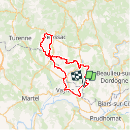
Tocht Mountainbike van 53 km beschikbaar op Nieuw-Aquitanië, Corrèze, Queyssac-les-Vignes. Deze tocht wordt voorgesteld door fesseneric.

Beschrijving

Au départ du stade de Chauffour sur veil direction Vayrac dans le lot par des petites routes (pas de chemins)puis queyssac les vignes, avec de beaux points de vues, passage par Curemonte et retour près du départ pour une dernière boucle pour traverser Collonges la rouge.

Hoogteprofiel

Plaatsbepaling

Land:
France
Regio :
Nieuw-Aquitanië
Departement/Provincie :
Corrèze
Gemeente :
Queyssac-les-Vignes
Locatie:
Unknown
Vertrek:(Dec)
Vertrek:(UTM)
401825 ; 4979158 (31T) N.

Wandeltochten in de omgeving

Tocht Stappen Bilhac - BILLAC - Photo
Stappen
houbart

Stappen

Moeilijk
(1)
Bilhac, Nieuw-Aquitanië, Corrèze, France
10,3 km | 13,3 km-effort
3h 0min
Ja
Tocht Mountainbike Curemonte - Circuit des sentes - Photo
Mountainbike
sdroneau

Mountainbike

Moeilijk
(1)
Curemonte, Nieuw-Aquitanië, Corrèze, France
26 km | 37 km-effort
3h 4min
Ja
Tocht Stappen Queyssac-les-Vignes - Entre vignes et noyers - Queyssac les Vignes - Photo
Stappen
tracegps

Stappen

Medium
(1)
Queyssac-les-Vignes, Nieuw-Aquitanië, Corrèze, France
8 km | 10,7 km-effort
2h 0min
Ja
Tocht Stappen Queyssac-les-Vignes - Le vin paillé - Photo
Stappen
sdroneau

Stappen

Gemakkelijk
(1)
Queyssac-les-Vignes, Nieuw-Aquitanië, Corrèze, France
10,4 km | 13,8 km-effort
2h 30min
Ja
Tocht Stappen Queyssac-les-Vignes - Fred BC Queyssac-les-Vignes  - Photo
Stappen
arnoultjf

Stappen

Medium
Queyssac-les-Vignes, Nieuw-Aquitanië, Corrèze, France
8,6 km | 11,6 km-effort
2h 48min
Ja
Tocht Stappen Vayrac - Vayrac- Puy d'Issolud - Photo
Stappen
houbart

Stappen

Moeilijk
Vayrac, Occitanië, Lot, France
12,9 km | 17,8 km-effort
4h 1min
Ja
Tocht Stappen Queyssac-les-Vignes - Chemin de la Queyrille - Queyssac les Vignes  - Photo
Stappen
tracegps

Stappen

Medium
Queyssac-les-Vignes, Nieuw-Aquitanië, Corrèze, France
5,4 km | 7,7 km-effort
1h 30min
Ja
Tocht Stappen Bilhac - mas del pouch par moulin de la force - Photo
Stappen
pmuet

Stappen

Heel gemakkelijk
(2)
Bilhac, Nieuw-Aquitanië, Corrèze, France
8,4 km | 10,7 km-effort
2h 18min
Ja
Tocht Stappen Carennac - La Via Arverna  (Carennac - Rocamadour) - Photo
Stappen
tracegps

Stappen

Moeilijk
Carennac, Occitanië, Lot, France
27 km | 36 km-effort
7h 45min
Neen


Sluiten
Mijn abonnementen