Tocht Lopen Saint-Thégonnec Loc-Eguiner - Trail du Tro Milinou - Photo
 srdt29
srdt29

Gebruiker

© OpenStreetMap contributors
Lengte
Lengte
29 km
Max. hoogte
Max. hoogte
367 m
Positief hoogteverschil
611 m
Km-Effort
Km-Effort  
37 km
Min. hoogte
Min. hoogte
94 m
Negatief hoogteverschil
610 m
Boucle
Boucle
Ja
Datum van aanmaak :
2019-01-29 19:36:46.51
Laatste wijziging :
2020-07-30 18:02:40.051

(0 Bericht)

Lopen
Lopen
3h00
Moeilijkheid : Moeilijk

Scan deze QR-code om de tocht te openen in de SityTrail-applicatie

Gratisgps-wandelapplicatie

Logo SityTrail SityTrail

IGN / Geografische instituten

SityTrail uit de App Store downloaden SityTrail uit Google Play downloaden

Logo SityTrail SityTrail World

De wereld gaat voor u open

SityTrail uit de App Store downloaden SityTrail uit Google Play downloaden SityTrail op Huawei AppGallery downloaden

Over ons

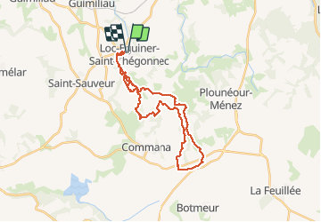
Tocht Lopen van 29 km beschikbaar op Bretagne, Finistère, Saint-Thégonnec Loc-Eguiner. Deze tocht wordt voorgesteld door srdt29.

Beschrijving

Trail des roc'h
St-Thégonnec Loc-Eguiner (29)

Hoogteprofiel

Plaatsbepaling

Land:
France
Regio :
Bretagne
Departement/Provincie :
Finistère
Gemeente :
Saint-Thégonnec Loc-Eguiner
Locatie:
Unknown
Vertrek:(Dec)
Vertrek:(UTM)
428310 ; 5368128 (30U) N.

Wandeltochten in de omgeving

Tocht Stappen Guimiliau - Guimiliau et Lampaul-Guimiliau - Photo
Stappen
RonanDAGORN

Stappen

Zeer moeilijk
(1)
Guimiliau, Bretagne, Finistère, France
20 km | 24 km-effort
5h 23min
Ja
Tocht Te voet Lampaul-Guimiliau - Circuit de Sainte-Anasthasie - Photo
Te voet
PRO

Te voet

Gemakkelijk
Lampaul-Guimiliau, Bretagne, Finistère, France
9,7 km | 11,8 km-effort
2h 40min
Ja
Tocht Stappen Lampaul-Guimiliau - petite st anne - Photo
Stappen
siboutchou

Stappen

Gemakkelijk
Lampaul-Guimiliau, Bretagne, Finistère, France
7,2 km | 8,5 km-effort
1h 35min
Ja
Tocht Te voet Saint-Sauveur - Circuit de Goas ar Scoul - Photo
Te voet
PRO

Te voet

Gemakkelijk
Saint-Sauveur, Bretagne, Finistère, France
8 km | 10 km-effort
2h 16min
Neen
Tocht Stappen Guimiliau - 12237073-Circuit des deux rivières - Photo
Stappen
RonanDAGORN

Stappen

Medium
Guimiliau, Bretagne, Finistère, France
14,7 km | 17,5 km-effort
3h 58min
Ja
Tocht Te voet Saint-Thégonnec Loc-Eguiner - Circuit du Fers - Photo
Te voet
PRO

Te voet

Gemakkelijk
Saint-Thégonnec Loc-Eguiner, Bretagne, Finistère, France
4,1 km | 5 km-effort
1h 8min
Ja
Tocht Stappen Lampaul-Guimiliau - st Anne ( lampaul guimiliau) - Photo
Stappen
siboutchou

Stappen

Gemakkelijk
Lampaul-Guimiliau, Bretagne, Finistère, France
12,7 km | 15,2 km-effort
2h 42min
Ja
Tocht Stappen Guimiliau - etang moulin.gpx - Photo
Stappen
damienbral

Stappen

Heel gemakkelijk
Guimiliau, Bretagne, Finistère, France
5 km | 5,8 km-effort
Onbekend
Ja
Tocht Stappen Guimiliau - etang moulin.gpx - Photo
Stappen
damienbral

Stappen

Heel gemakkelijk
Guimiliau, Bretagne, Finistère, France
5 km | 5,8 km-effort
Onbekend
Ja


Sluiten
Mijn abonnementen