


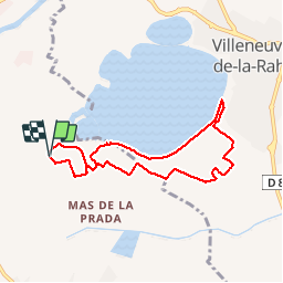

6,7 km | 7,5 km-effort


Gebruiker


Gratisgps-wandelapplicatie
 SityTrail
IGN / Geografische instituten
SityTrail World
De wereld gaat voor u open
Tocht Stappen van 7,8 km beschikbaar op Occitanië, Pyrénées-Orientales, Bages. Deze tocht wordt voorgesteld door jeff66.
66 BAGES, Vulpillères, La Llantia, promenade sur Les crêtes,Panorama sur les Albères, Et sur le lac de VILLENEUVE DE LA RAHO, LA Sobrepera, Els Etanyots, Val Marie, stade - Salle polyvalente - Pétanque - tennis, Mas Doat, le Lac

Stappen

Stappen

Stappen

Mountainbike
Quad

Stappen

Stappen

Stappen
Stappen