Tocht Stappen Précy-sur-Vrin - Précis projet - Photo
 Pleh
Pleh

Gebruiker

© OpenStreetMap contributors
Lengte
Lengte
8,3 km
Max. hoogte
Max. hoogte
177 m
Positief hoogteverschil
132 m
Km-Effort
Km-Effort  
10,1 km
Min. hoogte
Min. hoogte
105 m
Negatief hoogteverschil
130 m
Boucle
Boucle
Ja
Datum van aanmaak :
2019-04-28 13:59:36.302
Laatste wijziging :
2019-04-28 13:59:36.327

(0 Bericht)

Stappen
Stappen
2h10
Moeilijkheid : Gemakkelijk

Scan deze QR-code om de tocht te openen in de SityTrail-applicatie

Gratisgps-wandelapplicatie

Logo SityTrail SityTrail

IGN / Geografische instituten

SityTrail uit de App Store downloaden SityTrail uit Google Play downloaden

Logo SityTrail SityTrail World

De wereld gaat voor u open

SityTrail uit de App Store downloaden SityTrail uit Google Play downloaden SityTrail op Huawei AppGallery downloaden

Over ons

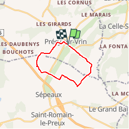
Tocht Stappen van 8,3 km beschikbaar op Bourgondië-Franche-Comté, Yonne, Précy-sur-Vrin. Deze tocht wordt voorgesteld door Pleh.

Hoogteprofiel

Plaatsbepaling

Land:
France
Regio :
Bourgondië-Franche-Comté
Departement/Provincie :
Yonne
Gemeente :
Précy-sur-Vrin
Locatie:
Unknown
Vertrek:(Dec)
Vertrek:(UTM)
518637 ; 5312550 (31T) N.

Wandeltochten in de omgeving

Tocht Stappen Cézy - Thèmes 9 Km - Photo
Stappen
mesnyjy

Stappen

Medium
(1)
Cézy, Bourgondië-Franche-Comté, Yonne, France
9,1 km | 11,6 km-effort
2h 29min
Ja
Tocht Stappen La Celle-Saint-Cyr - Les foulons-Le moulin d'en bas  - Photo
Stappen
papyjv8991

Stappen

Gemakkelijk
La Celle-Saint-Cyr, Bourgondië-Franche-Comté, Yonne, France
5,2 km | 6,4 km-effort
1h 41min
Ja
Tocht Stappen Précy-sur-Vrin - Rando Jovinien Précy sur Vrin (8,3 km) - Photo
Stappen
Pleh

Stappen

Gemakkelijk
Précy-sur-Vrin, Bourgondië-Franche-Comté, Yonne, France
8,3 km | 9,8 km-effort
2h 8min
Ja
Tocht Stappen Précy-sur-Vrin - Précy sur Vrin 8,3 km - Photo
Stappen
Pleh

Stappen

Gemakkelijk
Précy-sur-Vrin, Bourgondië-Franche-Comté, Yonne, France
8,3 km | 9,9 km-effort
2h 9min
Ja
Tocht Paard La Celle-Saint-Cyr - Géro.Etape3 - Photo
Paard
aucamus

Paard

Heel gemakkelijk
La Celle-Saint-Cyr, Bourgondië-Franche-Comté, Yonne, France
24 km | 27 km-effort
3h 28min
Neen
Tocht Stappen La Celle-Saint-Cyr - La Petite Celle - Le Vrin - point de vue à Thèmes - Photo
Stappen
py.bretecher

Stappen

Gemakkelijk
(2)
La Celle-Saint-Cyr, Bourgondië-Franche-Comté, Yonne, France
5,5 km | 6,8 km-effort
Onbekend
Ja
Tocht Ezelwandeling La Celle-Saint-Cyr - 2023-04-12_17h09m45_geronimo_compostelle_5_eme_etape-15911470-1681312170-659 - Photo
Ezelwandeling
aucamus

Ezelwandeling

Heel gemakkelijk
La Celle-Saint-Cyr, Bourgondië-Franche-Comté, Yonne, France
19 km | 24 km-effort
Onbekend
Neen
Tocht Te voet La Celle-Saint-Cyr - La Celle - Peteloup - Thèmes - La Celle - Photo
Te voet
Papymimi

Te voet

Gemakkelijk
(1)
La Celle-Saint-Cyr, Bourgondië-Franche-Comté, Yonne, France
11 km | 13,2 km-effort
3h 0min
Ja
Tocht Te voet La Celle-Saint-Cyr - La Celle St Cyr/Chartreuse 13 km - Photo
Te voet
Pleh

Te voet

Gemakkelijk
La Celle-Saint-Cyr, Bourgondië-Franche-Comté, Yonne, France
12,5 km | 15 km-effort
Onbekend
Ja


Sluiten
Mijn abonnementen