Tocht Stappen Sainte-Bazeille - couthures  - Photo
 sandrineh
sandrineh

Gebruiker

© OpenStreetMap contributors
Lengte
Lengte
6,3 km
Max. hoogte
Max. hoogte
30 m
Positief hoogteverschil
43 m
Km-Effort
Km-Effort  
6,9 km
Min. hoogte
Min. hoogte
13 m
Negatief hoogteverschil
51 m
Boucle
Boucle
Ja
Datum van aanmaak :
2016-07-15 00:00:00.0
Laatste wijziging :
2016-07-15 00:00:00.0

(0 Bericht)

Stappen
Stappen
2h58
Moeilijkheid : Heel gemakkelijk

Scan deze QR-code om de tocht te openen in de SityTrail-applicatie

Gratisgps-wandelapplicatie

Logo SityTrail SityTrail

IGN / Geografische instituten

SityTrail uit de App Store downloaden SityTrail uit Google Play downloaden

Logo SityTrail SityTrail World

De wereld gaat voor u open

SityTrail uit de App Store downloaden SityTrail uit Google Play downloaden SityTrail op Huawei AppGallery downloaden

Over ons

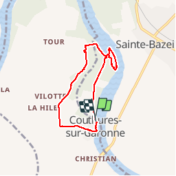
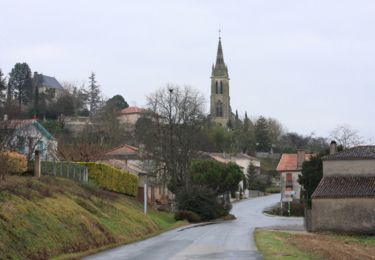
Tocht Stappen van 6,3 km beschikbaar op Nieuw-Aquitanië, Lot-et-Garonne, Sainte-Bazeille. Deze tocht wordt voorgesteld door sandrineh.

Beschrijving

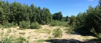
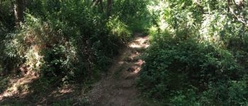
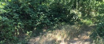
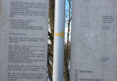
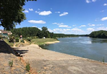
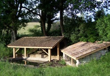
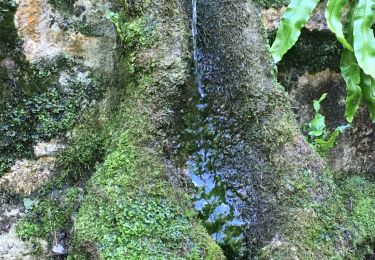
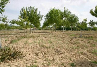
Départ sur le chemin qui passe entre les peupliers. Petit tour des îles (attention au coefficient et aux heures de marées) puis retour par un chemin herbeux et pour finir la route pour arriver au village. Prévoir des chaussures hautes voire des pantalons pour les herbes hautes et les orties. Peut être même des manches longues pour s'aventurer sur des sentiers non entretenus.

Hoogteprofiel

Foto's

POI's

POI Sainte-Bazeille - parking - Photo
sandrineh
SAINTE-BAZEILLE 
POI Sainte-Bazeille - sur l'île  - Photo
sandrineh
SAINTE-BAZEILLE 
POI Sainte-Bazeille - plage de galets - Photo
sandrineh
SAINTE-BAZEILLE 
POI Sainte-Bazeille - chemin mais plein d'orties - Photo
sandrineh
POI Sainte-Bazeille - marches taillées dans la terre.  - Photo
sandrineh
POI Sainte-Bazeille - chemin d'accès aux îles.  - Photo
sandrineh
POI Sainte-Bazeille - chemin de terre entre Garonne et peupliers.  - Photo
sandrineh
POI Couthures-sur-Garonne - croisement - Photo
sandrineh
COUTHURES-SUR-GARONNE 
POI Couthures-sur-Garonne - chemin de terre - Photo
sandrineh
COUTHURES-SUR-GARONNE 
POI Couthures-sur-Garonne - grange - Photo
sandrineh
COUTHURES-SUR-GARONNE 
POI Couthures-sur-Garonne - chemin herbeux - Photo
sandrineh
COUTHURES-SUR-GARONNE 
POI Couthures-sur-Garonne - habitations - Photo
sandrineh
COUTHURES-SUR-GARONNE 
POI Couthures-sur-Garonne - route  - Photo
sandrineh
COUTHURES-SUR-GARONNE 
POI Couthures-sur-Garonne - parking village. gens de Garonne  - Photo
sandrineh
COUTHURES-SUR-GARONNE 

Plaatsbepaling

Land:
France
Regio :
Nieuw-Aquitanië
Departement/Provincie :
Lot-et-Garonne
Gemeente :
Sainte-Bazeille
Locatie:
Unknown
Vertrek:(Dec)
Vertrek:(UTM)
267853 ; 4933298 (31T) N.

Wandeltochten in de omgeving

Tocht Stappen Jusix - Jusix - Photo
Stappen
Briarwood

Stappen

Heel gemakkelijk
Jusix, Nieuw-Aquitanië, Lot-et-Garonne, France
7,9 km | 8,2 km-effort
2h 18min
Ja
Tocht Stappen Sainte-Bazeille - couthures  - Photo
Stappen
sandrineh

Stappen

Heel gemakkelijk
Sainte-Bazeille, Nieuw-Aquitanië, Lot-et-Garonne, France
6,3 km | 6,9 km-effort
2h 58min
Ja
Tocht Paard Castelnau-sur-Gupie - Castelnau sur Gupie, dans les coteaux de Garonne - Photo
Paard
tracegps

Paard

Medium
Castelnau-sur-Gupie, Nieuw-Aquitanië, Lot-et-Garonne, France
14,3 km | 18,7 km-effort
2h 25min
Ja
Tocht Mountainbike Castelnau-sur-Gupie - Castelnau sur Gupie, dans les coteaux de Garonne - Photo
Mountainbike
tracegps

Mountainbike

Medium
Castelnau-sur-Gupie, Nieuw-Aquitanië, Lot-et-Garonne, France
14,3 km | 18,7 km-effort
1h 49min
Ja
Tocht Stappen Castelnau-sur-Gupie - Castelnau sur Gupie, dans les coteaux de Garonne - Photo
Stappen
tracegps

Stappen

Moeilijk
Castelnau-sur-Gupie, Nieuw-Aquitanië, Lot-et-Garonne, France
14,3 km | 18,7 km-effort
3h 49min
Ja
Tocht Stappen Meilhan-sur-Garonne - Meillhan sur Garonne - Photo
Stappen
Briarwood

Stappen

Gemakkelijk
Meilhan-sur-Garonne, Nieuw-Aquitanië, Lot-et-Garonne, France
4,6 km | 5,7 km-effort
1h 31min
Ja
Tocht Paard Castelnau-sur-Gupie - Castelnau-sur-Gupie, dans les coteaux de Garonne - Pays du Dropt - Photo
Paard
tracegps

Paard

Moeilijk
Castelnau-sur-Gupie, Nieuw-Aquitanië, Lot-et-Garonne, France
14,3 km | 18,7 km-effort
2h 25min
Ja
Tocht Mountainbike Castelnau-sur-Gupie - Castelnau-sur-Gupie, dans les coteaux de Garonne - Pays du Dropt - Photo
Mountainbike
tracegps

Mountainbike

Moeilijk
Castelnau-sur-Gupie, Nieuw-Aquitanië, Lot-et-Garonne, France
14,3 km | 18,7 km-effort
1h 49min
Ja
Tocht Stappen Castelnau-sur-Gupie - Castelnau-sur-Gupie, dans les coteaux de Garonne - Pays du Dropt - Photo
Stappen
tracegps

Stappen

Moeilijk
Castelnau-sur-Gupie, Nieuw-Aquitanië, Lot-et-Garonne, France
14,3 km | 18,7 km-effort
3h 49min
Ja


Sluiten
Mijn abonnementen