Tocht Stappen Saint-Martin-Vésubie - Lacs dePrals - Photo
 patsure
patsure

Gebruiker

© OpenStreetMap contributors
Lengte
Lengte
8,3 km
Max. hoogte
Max. hoogte
2338 m
Positief hoogteverschil
528 m
Km-Effort
Km-Effort  
15,4 km
Min. hoogte
Min. hoogte
1815 m
Negatief hoogteverschil
526 m
Boucle
Boucle
Ja
Datum van aanmaak :
2016-07-16 00:00:00.0
Laatste wijziging :
2020-09-08 14:21:45.618

(0 Bericht)

Stappen
Stappen
4h31
Moeilijkheid : Onbekend

Scan deze QR-code om de tocht te openen in de SityTrail-applicatie

Gratisgps-wandelapplicatie

Logo SityTrail SityTrail

IGN / Geografische instituten

SityTrail uit de App Store downloaden SityTrail uit Google Play downloaden

Logo SityTrail SityTrail World

De wereld gaat voor u open

SityTrail uit de App Store downloaden SityTrail uit Google Play downloaden SityTrail op Huawei AppGallery downloaden

Over ons

Tocht Stappen van 8,3 km beschikbaar op Provence-Alpes-Côte d'Azur, Alpes-Maritimes, Saint-Martin-Vésubie. Deze tocht wordt voorgesteld door patsure.

Hoogteprofiel

Foto's

POI's

POI Saint-Martin-Vésubie - Point 1 - Photo
patsure
SAINT-MARTIN-VÉSUBIE 
POI Saint-Martin-Vésubie - baliqe 364 tourner à gauche  - Photo
patsure
SAINT-MARTIN-VÉSUBIE 
POI Saint-Martin-Vésubie - Point 6 - Photo
patsure
SAINT-MARTIN-VÉSUBIE 
POI Saint-Martin-Vésubie - col Point 8 - Photo
patsure
SAINT-MARTIN-VÉSUBIE 
POI Saint-Martin-Vésubie - au dessus de la Madonne de Fenestre Point 12 - Photo
patsure
SAINT-MARTIN-VÉSUBIE 

Plaatsbepaling

Land:
France
Regio :
Provence-Alpes-Côte d'Azur
Departement/Provincie :
Alpes-Maritimes
Gemeente :
Saint-Martin-Vésubie
Locatie:
Unknown
Vertrek:(Dec)
Vertrek:(UTM)
368450 ; 4883534 (32T) N.

Wandeltochten in de omgeving

Tocht Stappen Saint-Martin-Vésubie - Lac de Trécolpas - Photo
Stappen
patsure

Stappen

Medium
(2)
Saint-Martin-Vésubie, Provence-Alpes-Côte d'Azur, Alpes-Maritimes, France
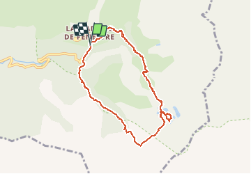
13,3 km | 20 km-effort
4h 17min
Ja
Tocht Stappen Saint-Martin-Vésubie - lacs bessons - Photo
Stappen
REYPatrick

Stappen

Heel gemakkelijk
(1)
Saint-Martin-Vésubie, Provence-Alpes-Côte d'Azur, Alpes-Maritimes, France
13,1 km | 0 m-effort
7h 36min
Ja
Tocht Te voet Belvédère - Les Merveilles par la Gordolasque - Photo
Te voet
PRO

Te voet

Medium
Belvédère, Provence-Alpes-Côte d'Azur, Alpes-Maritimes, France
13 km | 29 km-effort
6h 35min
Ja
Tocht Te voet Saint-Martin-Vésubie - Circuit de Fenestre - Photo
Te voet
PRO

Te voet

Gemakkelijk
Saint-Martin-Vésubie, Provence-Alpes-Côte d'Azur, Alpes-Maritimes, France
8,1 km | 16,4 km-effort
3h 44min
Ja
Tocht Te voet Saint-Martin-Vésubie - Circuit de Trécolpas - Photo
Te voet
PRO

Te voet

Gemakkelijk
Saint-Martin-Vésubie, Provence-Alpes-Côte d'Azur, Alpes-Maritimes, France
8,9 km | 15,8 km-effort
3h 35min
Ja
Tocht Stappen Saint-Martin-Vésubie - Cime de l'Agnellière via Lac de Trécolpas et Pas des Ladres - Photo
Stappen
michlie

Stappen

Medium
(1)
Saint-Martin-Vésubie, Provence-Alpes-Côte d'Azur, Alpes-Maritimes, France
14,4 km | 28 km-effort
5h 57min
Ja
Tocht Stappen Saint-Martin-Vésubie - Lacs de Prals - Photo
Stappen
michlie

Stappen

Gemakkelijk
(1)
Saint-Martin-Vésubie, Provence-Alpes-Côte d'Azur, Alpes-Maritimes, France
6,7 km | 13,5 km-effort
2h 48min
Ja
Tocht Andere activiteiten Saint-Martin-Vésubie - gr 52 merveilles - Photo
Andere activiteiten
legris

Andere activiteiten

Heel gemakkelijk
(1)
Saint-Martin-Vésubie, Provence-Alpes-Côte d'Azur, Alpes-Maritimes, France
27 km | 53 km-effort
Onbekend
Neen
Tocht Stappen Belvédère - Tête du Lac Autier - Photo
Stappen
bozo1970

Stappen

Zeer moeilijk
Belvédère, Provence-Alpes-Côte d'Azur, Alpes-Maritimes, France
9,9 km | 24 km-effort
5h 54min
Ja


Sluiten
Mijn abonnementen