Tocht Stappen Lignières-de-Touraine - Lignières-de-Touraine - la Chapelle-aux-Naux - 24 km 4h45mn  - Photo

Lignières-de-Touraine - la Chapelle-aux-Naux - 24 km 4h45mn

 Orcal37
Orcal37

Gebruiker

© OpenStreetMap contributors
Lengte
Lengte
24 km
Max. hoogte
Max. hoogte
98 m
Positief hoogteverschil
177 m
Km-Effort
Km-Effort  
27 km
Min. hoogte
Min. hoogte
35 m
Negatief hoogteverschil
178 m
Boucle
Boucle
Ja
Datum van aanmaak :
2016-08-13 00:00:00.0
Laatste wijziging :
2021-08-09 14:21:13.822

(0 Bericht)

Stappen
Stappen
4h45
Moeilijkheid : Medium

Scan deze QR-code om de tocht te openen in de SityTrail-applicatie

Gratisgps-wandelapplicatie

Logo SityTrail SityTrail

IGN / Geografische instituten

SityTrail uit de App Store downloaden SityTrail uit Google Play downloaden

Logo SityTrail SityTrail World

De wereld gaat voor u open

SityTrail uit de App Store downloaden SityTrail uit Google Play downloaden SityTrail op Huawei AppGallery downloaden

Over ons

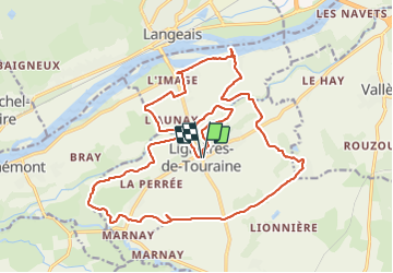
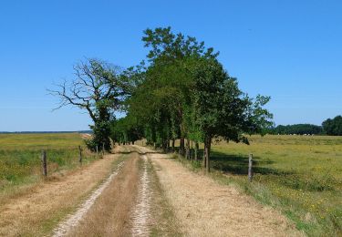
Tocht Stappen van 24 km beschikbaar op Centre-Val de Loire, Indre-et-Loire, Lignières-de-Touraine. Deze tocht wordt voorgesteld door Orcal37.

Beschrijving

Lignières-de-Touraine - la Chapelle-aux-Naux - 24 km 4h45mn   45mn dej

Hoogteprofiel

Foto's

Plaatsbepaling

Land:
France
Regio :
Centre-Val de Loire
Departement/Provincie :
Indre-et-Loire
Gemeente :
Lignières-de-Touraine
Locatie:
Unknown
Vertrek:(Dec)
Vertrek:(UTM)
304742 ; 5241451 (31T) N.

Wandeltochten in de omgeving

Tocht Stappen Lignières-de-Touraine - Lignière de Touraine-Le 26-09-2013- Distance 10,4 km - Auteur tintin37 - Photo
Stappen
Martinjeanclaude

Stappen

Medium
(2)
Lignières-de-Touraine, Centre-Val de Loire, Indre-et-Loire, France
10,4 km | 11,8 km-effort
2h 30min
Ja
Tocht Fiets Cheillé - Au Pays d'Azay-le-Rideau - Photo
Fiets
leeho

Fiets

Gemakkelijk
(1)
Cheillé, Centre-Val de Loire, Indre-et-Loire, France
53 km | 58 km-effort
2h 40min
Neen
Tocht Stappen Langeais - Langeais - PR Saint-Michel-sur-Loire - 20.8km 325m 5h10 (30mn) - 2023 04 15 - Photo
Stappen
Orcal37

Stappen

Medium
Langeais, Centre-Val de Loire, Indre-et-Loire, France
21 km | 25 km-effort
5h 10min
Ja
Tocht Stappen Azay-le-Rideau - Azay-le-Rideau - Goupillières Baulay - 15.1km 185m 3h35 - 2022 07 12 - Photo
Stappen
Orcal37

Stappen

Gemakkelijk
Azay-le-Rideau, Centre-Val de Loire, Indre-et-Loire, France
15,1 km | 17,6 km-effort
3h 35min
Ja
Tocht Stappen Azay-le-Rideau - Azay-le-Rideau - l'Islette - 17km 220m 4h05 (20mn) - 2021 06 12 - Photo
Stappen
Orcal37

Stappen

Gemakkelijk
Azay-le-Rideau, Centre-Val de Loire, Indre-et-Loire, France
17 km | 20 km-effort
4h 5min
Ja
Tocht Stappen Cheillé - Cheillé - Circuits 1 et 2 - 13.2km 225m 2h40 - 2020 07 18 - Photo
Stappen
Orcal37

Stappen

Gemakkelijk
Cheillé, Centre-Val de Loire, Indre-et-Loire, France
13,2 km | 16,2 km-effort
2h 40min
Ja
Tocht Stappen Rivarennes - Rivarennes - Circuit 1 - 18.2km 225m 3h55 - 2020 07 13 - Photo
Stappen
Orcal37

Stappen

Gemakkelijk
Rivarennes, Centre-Val de Loire, Indre-et-Loire, France
18,2 km | 21 km-effort
3h 55min
Ja
Tocht Stappen Vallères - Vallères - Circuit 11km - 10.7km 115m 2h20 - 2020 07 11 - Photo
Stappen
Orcal37

Stappen

Heel gemakkelijk
Vallères, Centre-Val de Loire, Indre-et-Loire, France
10,7 km | 12,2 km-effort
2h 20min
Ja
Tocht Stappen Azay-le-Rideau - Azay le Rideau (les vergers) - Photo
Stappen
LEMENIO

Stappen

Gemakkelijk
Azay-le-Rideau, Centre-Val de Loire, Indre-et-Loire, France
11,3 km | 13,2 km-effort
3h 3min
Neen


Sluiten
Mijn abonnementen