Tocht Stappen Longny les Villages - Monceaux au Perche 7.4 Km - Photo

Monceaux au Perche 7.4 Km

 ODDAD78
ODDAD78

Gebruiker

© OpenStreetMap contributors
Lengte
Lengte
7,5 km
Max. hoogte
Max. hoogte
230 m
Positief hoogteverschil
163 m
Km-Effort
Km-Effort  
9,6 km
Min. hoogte
Min. hoogte
140 m
Negatief hoogteverschil
164 m
Boucle
Boucle
Ja
Datum van aanmaak :
2019-04-13 16:34:52.08
Laatste wijziging :
2019-04-13 16:34:52.112

(0 Bericht)

Stappen
Stappen
2h04
Moeilijkheid : Gemakkelijk

Scan deze QR-code om de tocht te openen in de SityTrail-applicatie

Gratisgps-wandelapplicatie

Logo SityTrail SityTrail

IGN / Geografische instituten

SityTrail uit de App Store downloaden SityTrail uit Google Play downloaden

Logo SityTrail SityTrail World

De wereld gaat voor u open

SityTrail uit de App Store downloaden SityTrail uit Google Play downloaden SityTrail op Huawei AppGallery downloaden

Over ons

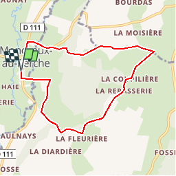
Tocht Stappen van 7,5 km beschikbaar op Normandië, Orne, Longny les Villages. Deze tocht wordt voorgesteld door ODDAD78.

Beschrijving

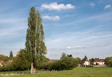
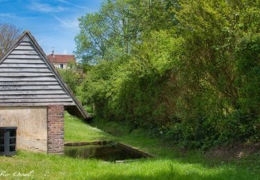
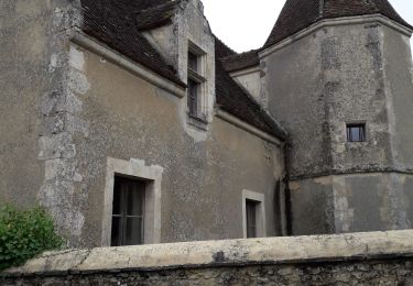
Le bois des Sicots. Point de départ au parking de la maire de Monceaux-au-Perche. Superbe vallée de la Jambéée aux panoramas nombreux et caractéristiques des paysages du Perche
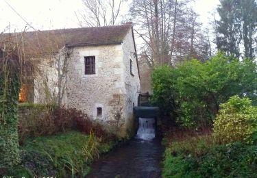
Au printemps / été, prendre le temps de visiter les jardins du manoir de Pontgirard

Hoogteprofiel

Plaatsbepaling

Land:
France
Regio :
Normandië
Departement/Provincie :
Orne
Gemeente :
Longny les Villages
Locatie:
Unknown
Vertrek:(Dec)
Vertrek:(UTM)
330397 ; 5372713 (31U) N.

Wandeltochten in de omgeving

Tocht Stappen Longny les Villages - Monceaux au Perche (Boucle) - Photo
Stappen
neitag61

Stappen

Gemakkelijk
(2)
Longny les Villages, Normandië, Orne, France
10,6 km | 13,5 km-effort
2h 30min
Ja
Tocht Stappen Bizou - [Itinéraire] Les sables du Perche - Photo
Stappen
ODDAD78

Stappen

Medium
Bizou, Normandië, Orne, France
9,2 km | 11 km-effort
2h 29min
Ja
Tocht Te voet Longny les Villages - Attelage - Forêt et Panoramas - forêt de Réno-Valdieu - Photo
Te voet
PRO

Te voet

Gemakkelijk
Longny les Villages, Normandië, Orne, France
7,6 km | 9,3 km-effort
2h 7min
Neen
Tocht Stappen La Chapelle-Montligeon - [Itinéraire] Le Mont Ligeon - Photo
Stappen
ODDAD78

Stappen

Medium
La Chapelle-Montligeon, Normandië, Orne, France
5,1 km | 6,6 km-effort
1h 30min
Ja
Tocht Stappen Cour-Maugis sur Huisne - 12102996-Maison Maugis 22.37 - Photo
Stappen
togolo28

Stappen

Medium
(1)
Cour-Maugis sur Huisne, Normandië, Orne, France
22 km | 28 km-effort
Onbekend
Ja
Tocht Stappen La Chapelle-Montligeon - La Chapelle-Montligeon - Longny-au-Perche via Bizou 16 km - Photo
Stappen

Stappen

Zeer moeilijk
La Chapelle-Montligeon, Normandië, Orne, France
15,9 km | 20 km-effort
4h 22min
Neen
Tocht Stappen La Chapelle-Montligeon - La Chapelle-Montligeon - Moutiers-au-Perche via Bizou 20 km - Photo
Stappen

Stappen

Zeer moeilijk
La Chapelle-Montligeon, Normandië, Orne, France
20 km | 26 km-effort
5h 33min
Neen
Tocht Stappen La Chapelle-Montligeon - La Chapelle-Montligeon - Le Mage via Bizou 18 km - Photo
Stappen

Stappen

Zeer moeilijk
La Chapelle-Montligeon, Normandië, Orne, France
17,9 km | 23 km-effort
4h 53min
Neen
Tocht Stappen Longny les Villages - Monceaux et le Manoir - Photo
Stappen
MichelRando7656

Stappen

Gemakkelijk
Longny les Villages, Normandië, Orne, France
7,6 km | 9,6 km-effort
3h 0min
Ja


Sluiten
Mijn abonnementen